Last updated: April 28, 2026
- Host rock: Mississippian limestone formations (Bangor, Monteagle, Saint Louis, Warsaw, Fort Payne, Pennington), exposed in the Sequatchie Valley floor and the Tennessee River Gorge walls beneath the Pennsylvanian sandstone caprock
- Regional context: Northern edge of the TAG (Tennessee, Alabama, Georgia) karst region, the densest karst landscape in the United States
- Principal karst hazard event: Foundation leakage at Hales Bar Dam (1913 to 1968), with leakage rising from a few cubic feet per second at construction to 2,000 cfs by the late 1950s, eventually requiring full replacement of the dam by Nickajack Dam in 1967
- Authoritative hydrogeologic study: USGS Scientific Investigations Report 2024-5089, "Karst flow paths in the Little Sequatchie and Pryor Cove watersheds," which confirmed cross-valley karst connectivity beneath the Sequatchie Valley floor
- Community pages most directly defined by karst: Coppinger Cove (Ship Cave and the Ship Creek resurgence), Battle Creek (sinking streams and Battle Creek Cave), Martin Springs (the springs at the head of Battle Creek), Jasper (Blue Spring municipal water source), Sequatchie Cave State Natural Area (Owen Spring), Haletown and Guild (the Hales Bar foundation karst), Sequatchie River and the Head of Sequatchie
- Adjacent project pages: Marion County caves (the cave-systems treatment) and Marion County geology (the stratigraphic and structural treatment)
Marion County's surface landscape is shaped almost as much by what happens underground as by what happens on top. The Mississippian limestones that floor the Sequatchie Valley and form the lower walls of the Tennessee River Gorge are soluble in weakly acidic rainwater, and across millions of years that water has dissolved passageways, voids, and conduits through the rock. The visible expression of that underground dissolution is karst: a landscape of sinkholes, springs, blue holes, sinking streams, and unpredictable subsurface drainage. This page covers the surface side of Marion County's karst, leaving the cave systems themselves to the caves page and the deeper stratigraphy and structure to the geology page.
Three things make the county's karst especially consequential. First, the karst is well-developed and extensive: most of the Sequatchie Valley floor, the lower flanks of Walden Ridge and the western escarpment, the Tennessee River Gorge bench, and the upland coves all sit on karstic limestone, so the county's natural drainage is fundamentally a karst-aquifer system. Second, the karst connects across what would otherwise be separate surface watersheds. USGS Scientific Investigations Report 2024-5089 documented that the Little Sequatchie and Pryor Cove systems are hydrogeologically linked beneath the valley floor, which means that contamination entering a sinkhole on one side of the valley can resurface at a spring on the other side with little attenuation. Third, the karst has been a recurring engineering and construction problem in the county's industrial history, most spectacularly at Hales Bar Dam, where a half-century of foundation leakage through karst voids ultimately forced the entire 1913 hydroelectric project to be replaced.
What karst is, and why it shapes the surface
The mechanism is simple in outline. Rainwater absorbs carbon dioxide from the atmosphere and the soil, becoming a weak carbonic acid that slowly dissolves calcium carbonate (limestone). Wherever that acidic water has access to soluble rock through fractures, joints, or bedding planes, it widens those openings over geological time. At depth, the result is the cave system treated on the caves page. At the surface, the result is karst: a landscape with no integrated stream network, irregular drainage, depressions where soil has slumped into expanding underground voids, and resurgences where underground water emerges as springs.
Marion County's karst is hosted in the same Mississippian limestone package that produces the cave systems. The geology page lays out the stratigraphy in detail: the Pennington, Bangor, Monteagle, Saint Louis, Warsaw, and Fort Payne formations, all carbonate-dominated and exposed where the river or the escarpment retreat has cut through the overlying Pennsylvanian sandstones. The Bangor Limestone in particular has been a recurring problem child for engineering: it is well-jointed, riddled with solution channels, and has been the foundation rock at several of the county's consequential industrial-era projects.
Sinkholes and dolines on the valley floor
Sinkholes are the most visible surface karst feature in Marion County. They take three broad forms in the county:
- Solution sinkholes form gradually as the underlying limestone dissolves, producing shallow saucer-shaped depressions that may pond water in wet weather and drain freely in dry. These are the dominant surface form across the Sequatchie Valley floor and across the broad upland coves.
- Cover-collapse sinkholes form when soil bridging an underground void fails, producing a sudden vertical-walled depression. These are the kind of sinkhole most likely to surprise property owners and to damage buildings or pavements; they are also the most photogenic of the three forms when fresh, with vertical walls of red clay and exposed limestone bedrock at the bottom.
- Cover-subsidence sinkholes form gradually as soil settles into long-existing voids beneath, producing slow ground-level subsidence rather than abrupt collapse.
The Sequatchie Valley floor and the larger coves carry hundreds to thousands of small sinkholes that are visible on USGS topographic maps as small closed contour loops. Most are agricultural-scale features measured in tens of feet across, used by farmers as natural ponds in wet years and tilled around in dry. Larger named sinkholes occur in clusters: the Coppinger Cove floor carries an especially well-developed sinkhole field associated with the Ship Cave system, the Battle Creek watershed has both sinking streams and clusters of solution sinkholes, and the upland surface around Pleasant Hill (logged at TNGenWeb as a "sinkhole community") is sufficiently sinkhole-pocked that it gives the place its informal local identity.
Sinking creeks and the disappearance of surface water
Several Marion County streams disappear into the limestone before reaching the Sequatchie River or the Tennessee River. These sinking creeks are among the most visually distinctive karst features in the county, because the surface watercourse simply ends at a swallet (a hole in the streambed) and continues underground.
Notable examples include:
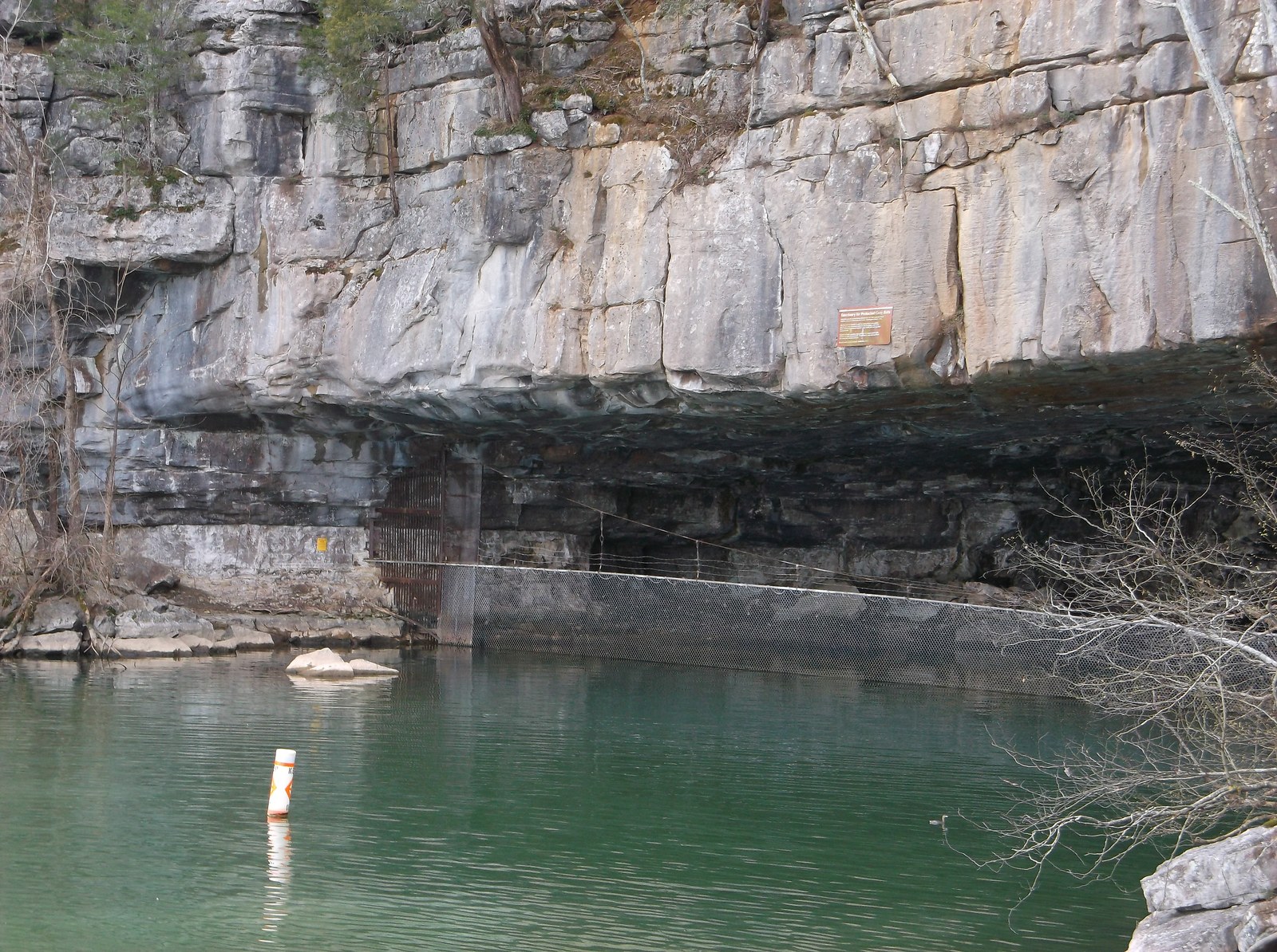
- Ship Creek in Coppinger Cove, which sinks into Ship Cave at the base of a cliff and resurfaces farther down the cove through the cave's two openings. The Southeastern Cave Conservancy mapped the system as part of the cove's broader karst inventory.
- Battle Creek tributaries above Battle Creek Cave (also called Monteagle Saltpeter Cave), where surface streams enter the karst system, run underground for stretches, and reemerge as springs farther down the watershed. The Civil-War-era saltpeter mining at Battle Creek Cave depended on the same karst conduit network for the cave's earth-floor sediments.
- Sequatchie River tributaries at multiple points, where small streams entering from the valley walls vanish into the limestone before reaching the river itself. The cumulative effect is that the Sequatchie River carries less surface flow than its drainage area would predict, with a substantial fraction of the rainfall budget moving through the karst system rather than the surface stream network.
Springs and blue holes
Where karst water resurfaces, it produces a spring. The county has several well-documented major springs that supply both ecological habitat and historic and modern community water sources:
- Head of Sequatchie, just north of the Marion County line in Cumberland County, is the principal source of the Sequatchie River and one of the largest karst resurgences in southeast Tennessee. The spring discharge sets the river's baseflow through Marion County.
- Blue Spring, near Jasper, is the municipal water source for the town of Jasper and one of only two known habitats of the federally endangered Royal Snail. Blue Spring and Owen Spring are documented in detail on the endemic and notable species page.
- Owen Spring, at the mouth of Sequatchie Cave in Sequatchie Cave State Natural Area roughly four miles from Blue Spring, is the second known Royal Snail habitat and the type locality for the Sequatchie Caddisfly. Both species depend on the same karst conduit network that links the two springs.
- The springs at Martin Springs, at the head of Battle Creek where the cumberland Plateau meets the Sequatchie Valley, are the namesake of the community and the geographic reason the John Bell detachment of the Trail of Tears camped here in 1838. The springs rise at the base of the plateau and feed Battle Creek through Battle Creek Cove.
- Doran Cove springs feed the small creek that drains the cove south toward Bridgeport, Alabama; the same karst connects the Doran Cove and Battle Creek watersheds at depth.
- Numerous unnamed cove-base springs ring the Cumberland Plateau escarpment in the county. These are the small but reliable water sources that historically defined the locations of the early settler-era farmsteads at the base of the bluffs across Mullins Cove, Pryor Cove, and Ladds Cove.
The blue-hole subset of these springs (deep, near-vertical, intensely blue-tinted) are the most striking visually but the smallest in absolute number; most of the county's spring discharge is at smaller, low-flow point sources rather than at deep blue-water pools.
Cross-valley karst connectivity: USGS SIR 2024-5089
For most of the 20th century the assumption among Sequatchie Valley landowners and county engineers was that the surface watershed boundaries (the ridge tops between coves, the divide between the Little Sequatchie and Pryor Cove drainages, the rim-versus-valley split) corresponded to subsurface flow boundaries: rain falling in Pryor Cove was assumed to drain through Pryor Cove, and rain falling in the Little Sequatchie watershed was assumed to drain through the Little Sequatchie. The 2024 USGS karst flow-path mapping demonstrated that this assumption was wrong.
USGS Scientific Investigations Report 2024-5089, Karst flow paths in the Little Sequatchie and Pryor Cove watersheds, published as part of the USGS Tennessee Water Science Center's karst-aquifer mapping work, used dye-tracer injections at upstream sinkholes and at sinking creeks to map the actual subsurface flow paths beneath the Sequatchie Valley floor in this part of the county. The dye recovery work confirmed that the two systems are hydrogeologically linked beneath the valley floor. The implication for land-use planning is straightforward: contamination entering a sinkhole on one side of the valley can surface at a spring on the other side with little attenuation. A spill upgradient of a Little Sequatchie sinkhole is therefore a Pryor Cove problem; a sewage failure in Pryor Cove is therefore a Little Sequatchie problem.
The 2024 mapping is the most authoritative single document on Marion County karst hydrogeology and is now the principal reference for the county's karst-water-quality planning under the Tennessee Department of Environment and Conservation karst-groundwater investigations program.
Karst hazards and the engineering record
Building large structures on karst is hard, and the county's industrial history has recorded the consequences twice over.
Hales Bar Dam (1913 to 1968): the marquee karst-foundation failure
Hales Bar Dam is the canonical karst- foundation case study in 20th-century American hydropower engineering. The 1913 dam was built across the Tennessee River on fractured Bangor Limestone, which the construction engineers had assessed only superficially before commitment. Once the reservoir was filled, leakage began almost immediately: the head differential across the dam pushed water down through the karst conduits in the foundation rock, around and beneath the dam itself, with surface expressions in springs and seeps downstream.
The leakage history is dismal. In 1919, engineers attempted to seal the foundation by pumping hot asphalt into the karst voids. The fix was partial. By 1931, a study showed the dam was leaking at 1,000 cubic feet per second: more than the average flow of many small Tennessee rivers, all of it bypassing the dam through its own foundation. After TVA acquired the dam in 1939, engineers brought the worst leakage under control by 1943 with extensive pressure grouting, but the gains were not durable. By the late 1950s, leakage had risen again to 2,000 cubic feet per second. A 1960 dye test revealed that interconnected leakage channels ran beneath the entire dam structure: the karst was outpacing the engineering.
TVA concluded that the foundation was unsalvageable. The agency built Nickajack Dam six miles downstream as a replacement; once Nickajack came online in 1967, Hales Bar was decommissioned, demolished in 1968, and Nickajack Lake drowned the original site. The Hales Bar lesson, "do not build a major dam on karst limestone without exhaustive subsurface mapping," became and remains a standard teaching example in civil-engineering and dam-safety curricula. Pressure grouting and concrete caisson construction, both pioneered or refined during the Hales Bar struggle, became standard tools in American dam construction in part because the Hales Bar failure trained an entire generation of engineers in their use.
Smaller-scale karst hazards in the county
The Hales Bar failure is the marquee case, but smaller-scale karst hazards recur across the county. Cover-collapse sinkholes have occasionally opened under farm outbuildings and pasture fences, and in a small number of documented cases beneath residential foundations on the valley floor. Sinking-stream loss has complicated agricultural irrigation planning and small-impoundment design in coves where surface water disappears unpredictably. The moonshining and prohibition history of the county leaned into the karst on purpose, with stills sited at remote cave entrances and at sinking-stream swallets that gave operators concealment, water, and natural drainage all in one feature.
Modern karst-hazard awareness on the valley floor is uneven. Tennessee Department of Environment and Conservation karst-resource files cover the larger known features, but the cumulative coverage of small sinkholes, individual swallets, and the actual connectivity of subsurface flow paths is partial. The 2024 USGS mapping closed the biggest single gap, but it covered only the Little Sequatchie and Pryor Cove watersheds; comparable mapping of Mullins Cove, Sweeten's Cove, Battle Creek, and the Tennessee River gorge bench would be substantial follow-on work.
Conservation and land-use implications
Karst landscapes pose four interlocking land-use problems that the county lives with in low-grade form throughout the year:
- Groundwater is everywhere and connects across long distances. Septic systems, agricultural runoff, fuel storage, and stormwater all enter the karst aquifer easily and can resurface at a spring miles away with minimal filtration. The 2024 USGS work confirmed that subsurface watersheds do not match surface watersheds in the county; surface-watershed-based planning is incomplete by design.
- Building foundations in karst are unpredictable. Most Marion County construction sits well within tolerances, but cover-collapse risk increases with construction-site loading, drainage changes, and water-table fluctuation. Drilling preconstruction borings in karst country is recommended for any structure heavier than a small house, and is required for major structures.
- Karst-dependent ecosystems are concentrated and vulnerable. Several Marion County endemic species, in particular the Tennessee cave salamander and a number of cave-adapted invertebrates documented in the endemic and notable species page, depend on cool, clean, stable karst water. Surface-water management decisions made well above the cave entrance can warm, contaminate, or dewater the cave habitat downstream.
- Karst-dependent water supplies are sensitive to upstream activity. Blue Spring (Jasper's municipal source), Owen Spring at Sequatchie Cave, the Martin Springs cluster at the head of Battle Creek, and many smaller cove-base springs that historically and currently feed community water systems pull from the same karst aquifer the surface farmland and septic systems drain into. Watershed-protection programs at the spring head are necessary but not sufficient; protection has to extend across the whole subsurface flow path.
TDEC's karst-groundwater-investigations program, the National Speleological Society's TAG region inventory, the Southeastern Cave Conservancy's protection work in Coppinger Cove and at adjacent county sites, and the USGS karst-flow-path mapping together amount to a useful but incomplete framework for managing the county's karst landscape. Where none of those programs reach, day-to-day land-use decisions still proceed on incomplete subsurface information.
Where karst meets the rest of Marion County
Almost every other geographic feature in the county is, in one form or another, also a karst story:
- The cave systems treated on the caves page (Nickajack, Sequatchie, Russell, Blowing, Battle Creek / Monteagle Saltpeter, and several hundred others) are the underground end of the same karst aquifer that produces the surface features here.
- The waterfalls described on the waterfalls page typically occur at the contact between resistant Pennsylvanian sandstone caprock and softer Mississippian limestone beneath; many of the county's smaller falls and spring-fed branches at that contact involve karst-aquifer discharge.
- The Hales Bar Dam failure was a karst-foundation failure in the same Bangor Limestone that hosts the Sequatchie River blue holes and the gorge-floor caves.
- The community pages for Coppinger Cove, Battle Creek, Martin Springs, Sweeten's Cove, and Haletown and Guild all live in or on visible karst, and reference back to this page for the broader karst context.
Related
Marion County caves →
Geology of Marion County (stratigraphy and structure) →
The Sequatchie River →
The Sequatchie Valley →
Endemic and notable species (the karst-dependent ones) →
Marion County waterfalls →
Hales Bar Dam (the karst-foundation case study) →
Coppinger Cove and Ship Cave →
Martin Springs (head of Battle Creek) →
Jasper (Blue Spring municipal water source) →
Endemic species at Blue Spring and Owen Spring (Royal Snail, Sequatchie Caddisfly) →
Sources
- USGS Scientific Investigations Report 2024-5089 — Karst groundwater flow paths, Little Sequatchie and Pryor Cove watersheds (the cross-valley karst-connectivity confirmation)
- TDEC — Tennessee Geological Survey
- USGS Professional Paper 996 — Upper Ordovician and Silurian Stratigraphy in Sequatchie Valley
- Wikipedia — Hales Bar Dam (the foundation-leakage timeline, 1913 to 1968)
- Wikipedia — Karst (the general mechanism)
- Wikipedia — Sequatchie Valley
- Wikipedia — Cumberland Plateau
- Wikipedia — Tennessee cave salamander (a karst-dependent endemic surfaced through the same aquifer system)