Last updated: April 19, 2026
- Type: Breached anticlinal valley
- Length: ~65 miles (river valley); over 150 miles geologically
- Width: 3 to 5 miles
- Orientation: Southwest to northeast
- East rim: Walden Ridge
- West rim: Cumberland Plateau escarpment
- Counties (Tennessee): Marion, Sequatchie, Bledsoe, Cumberland
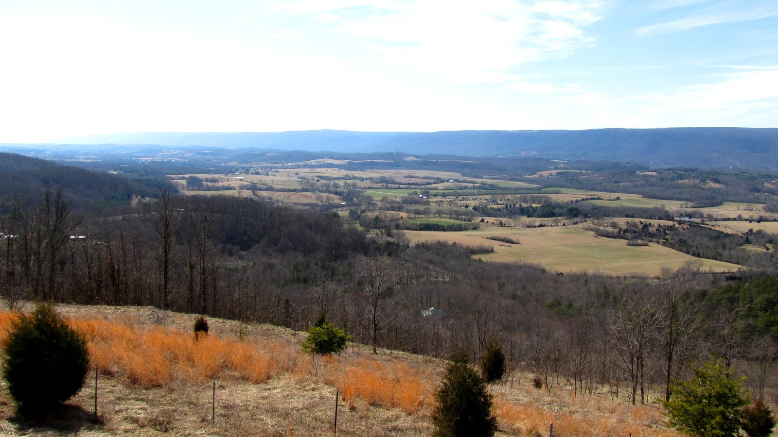
The Sequatchie Valley is the defining geographic feature of Marion County. Stretching roughly southwest-to-northeast through the southeastern Cumberland Plateau, it is one of the longest continuous valleys in the eastern United States. Marion County forms the valley's southern end, where the Sequatchie River empties into the Tennessee River near the Alabama border. Sequatchie and Bledsoe counties lie to the north. The valley is almost perfectly straight for its entire length, a consequence of the underlying geologic structure that produced it.
Geology
The valley is a breached anticline: an upward fold in the underlying rock layers whose crest eroded away over geologic time, leaving a long linear valley with steep escarpments rising 1,000 feet or more on either side. The anticline is now understood to be thrust-faulted on its northwest flank, part of a tectonic ramp that extends from the Lower Cambrian Rome Formation upward through younger rocks. The thrust flattens to the northwest into a detachment within weak shale and coal beds in Pennsylvanian-age deltaic sediments. Erosion cut through the limestone core of the anticline during the late Tertiary, exposing progressively older rock on the valley floor while the surrounding plateau retained its resistant caprock of Pennsylvanian sandstone and conglomerate.
The valley floor consists primarily of Ordovician and Silurian limestones and shales, while the plateau walls on either side are capped by Pennsylvanian sandstones. Walden Ridge, the eastern escarpment, separates the valley from the Tennessee River valley and the Ridge and Valley province to the east. The western wall is the main Cumberland Plateau surface. Terrain through Marion County is characterized by dissected uplands, steep escarpments, narrow alluvial bottoms along the Sequatchie River, and bluffs above the Tennessee River Gorge where the valley meets the river.
The Sequatchie River
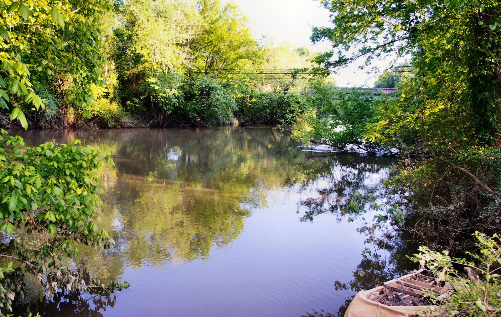
The valley takes its name from the Sequatchie River, a 116-mile waterway that drains a basin of roughly 602 square miles. The river originates from several springs at or near Devilstep Hollow Cave in Cumberland County. The principal spring, called Head of the Sequatchie, is protected as part of Cumberland Trail State Park. Dye-trace studies have established that the spring water originates in Grassy Cove, a large limestone sinkhole northeast of the valley, where surface streams disappear underground and reemerge as the Sequatchie's headwaters.
From its headwaters the river flows southwest through Bledsoe, Sequatchie, and Marion counties. In Marion County, the river passes through Whitwell and Jasper before emptying into the Tennessee River south of Interstate 24, near the Alabama state line. The Little Sequatchie River, a right tributary, joins the main stem near the community of Sequatchie. At a USGS gauging station near Whitwell, the river's average discharge is 745 cubic feet per second, with recorded extremes ranging from 16 cfs in September 1925 to 32,500 cfs during the March 1973 floods. The name comes from a Cherokee word (variously rendered Siquatchi or Se-qua-cha-ha-hok), generally interpreted as meaning "opossum" or referring to the river's winding path.
Ecology
The Sequatchie Valley supports a range of habitats shaped by its unusual geology and hydrology. The valley floor is dominated by mixed mesophytic forest, with oaks, hickories, elms, maples, American beech, tulip poplar, and pines. Roughly 77 percent of Sequatchie County's 176,240 acres is forested. A vascular flora study of the valley within Sequatchie County (2008 to 2010) documented 767 plant species across 379 genera and 116 families.
The valley's karst springs are of particular ecological importance. Sequatchie Cave State Natural Area, located in Marion County, harbors three federally and state-listed animal species and three additional species of state concern. The most notable is the Royal Snail (Marstonia ogmorhaphe), a freshwater snail under 5 millimeters in size, federally listed as endangered. It is known from only two springs in the Sequatchie River system in Marion County: Blue Spring, which supplies the town of Jasper's water, and Owen Spring four miles away. The Sequatchie Caddisfly (Glyphopsyche sequatchie) was first described from Sequatchie Cave and is reported from only three other spring-fed streams, all in Marion County. The cave is also the type locality for two terrestrial cave obligates, the Blowing Cave beetle (Pseudanophthalmus ventus) and the cave millipede Scoterpes ventus, both eyeless, depigmented species known only from this cave and its subterranean drainage. These species' extreme range restrictions make the valley's spring system one of the more significant aquatic and cave biodiversity sites on the southern Cumberland Plateau. For detailed treatments, see the endemic and notable species page.
Cherokee and early Anglo-American settlement
The Sequatchie Valley was part of the Cherokee Nation's domain before Anglo-American settlement. The Cherokee maintained villages, agricultural fields, and hunting grounds throughout the valley and along the Tennessee River. In the late 1770s, dissident Chickamauga Cherokee under Dragging Canoe relocated southward and established fortified settlements including Nickajack Town and Running Water in what is now southern Marion County, using the gorge and valley as defensive positions during the Chickamauga Wars.
The Cherokee ceded the Sequatchie Valley area to the United States through a series of treaties, culminating in the Treaty at the Cherokee Agency in 1817. Marion County was established that same year from the ceded territory, named for General Francis Marion of the American Revolution. Betsy Pack, a Cherokee woman, sold commissioners forty acres for the county seat; the first courthouse was built near the center of that tract in 1820. The remaining Cherokee in the region were forcibly removed during the Trail of Tears in 1838.
Farming, small towns, and communities followed the valley floor and slopes where water and easier terrain were available. Jasper, Whitwell, Kimball, South Pittsburg, Sweeten's Cove, and the community named Sequatchie all lie in the Marion County portion of the valley. Agriculture remains important on the valley floor, with hay, soybeans, corn, and small grains as the principal crops.
Present-day use
The Sequatchie Valley National Scenic Byway runs through Marion, Sequatchie, Bledsoe, and Cumberland counties, following the valley between Walden Ridge and the Cumberland Plateau. Jasper is one of the byway's signature stops. The valley's agricultural landscape, plateau rim overlooks, and small-town character are central to the byway's appeal.
Sequatchie Cave State Natural Area, managed by the Tennessee Department of Environment and Conservation, protects the cave and its spring system. The site is significant for aquatic biodiversity research and groundwater monitoring, particularly for the endangered Royal Snail. USGS research published in 2024 has mapped karst groundwater flow paths in the Little Sequatchie and Pryor Cove watersheds, documenting how the region's karst geology routes water underground through limestone before it resurfaces as springs.
Related
About the Tennessee River Gorge →
About the Sequatchie community →
About Jasper →
About the Cumberland Trail →
About Marion County flora →
About Marion County fauna →
About endemic and notable species →
Sources
- Wikipedia: Sequatchie Valley
- Wikipedia: Sequatchie River
- Milici, R.C., "The Geology of the Sequatchie Valley Overthrust Block," University of Tennessee doctoral dissertation
- USGS Professional Paper 996: Upper Ordovician and Silurian Stratigraphy in Sequatchie Valley
- USGS: Sequatchie River near Whitwell, TN (stream gauge data)
- USGS SIR 2024-5089: Karst groundwater flow paths, Little Sequatchie and Pryor Cove watersheds
- TDEC: Sequatchie Cave State Natural Area
- Wikipedia: Royal Snail (Marstonia ogmorhaphe)
- Vascular Flora of the Sequatchie Valley, Sequatchie County, University of Tennessee at Chattanooga thesis
- Sequatchie Valley Scenic Byway, National Scenic Byway Foundation