Last updated: April 23, 2026
- Type: Unincorporated communities (often treated as one)
- Founded: c. 1905–1913
- Named for: Hale family of Sequatchie Valley farmers (Haletown, via the Hale's Bar sandbar); Josephus Conn Guild Sr., dam engineer and company organizer (Guild)
- Elevation: About 640 feet at the river
- ZIP code: 37340 (Haletown post office, descended from the 1906 Guild post office)
Haletown and Guild sit along the Tennessee River in the eastern portion of Marion County, on former Cherokee hunting grounds that opened to Anglo-American farming after the Cherokee Treaty of 1819. Both communities owe their modern form to a single massive early-20th-century industrial project, the construction of Hales Bar Dam (1905 to 1913), which required thousands of workers and prompted the rapid build-out of housing along both banks of the river.
Setting
Haletown and Guild lie at the eastern end of Marion County, where the Sequatchie Valley opens onto the Tennessee River gorge. The river here runs east to west around the base of Raccoon Mountain on the south and the Tennessee River Gorge on the north and west, with Interstate 24 carrying traffic across the gorge's southern shoulder. The confluence of the Nickajack Lake reservoir with the lower Sequatchie River sits a few miles to the west. Elevation at the river is about 640 feet; the bluffs above the north bank climb quickly to more than 1,500 feet on Raccoon Mountain and Aetna Mountain.
The name Haletown traces back to a sandbar in the Tennessee River long known as Hale's Bar, which took its name from the Hale family, early white settlers who farmed nearby land in the mid-19th century. Descendants of the original Hale family still live in the Sequatchie Valley. The bar gave its name first to the Chattanooga and Tennessee River Power Company's 1905 to 1913 dam project, and then to the post-dam community that grew around the old construction camp. Guild, the second name for the same cluster of homes and stores, was taken from Josephus Conn Guild Sr., the Chattanooga attorney and engineer who organized the dam company; the Guild post office opened August 11, 1906, while the dam was still under construction.
Cherokee and pre-Cherokee presence
Long before the Hale family, the cove below Raccoon Mountain and the bottomland at the mouth of the Sequatchie River were used by Indigenous peoples. Archaeological sites along the gorge and around Nickajack Cave document Archaic and Woodland occupation (roughly 8000 BC to AD 900), and Mississippian villages (c. AD 900 to 1600) worked the same river flats that later supported the first Anglo-American farms. The U-bend of the river, with its fishing grounds, spring mouths, and proximity to Nickajack Cave, was a long-term draw for human use.
By the late 18th century this was Cherokee country, specifically the ground around the Chickamauga (Lower) Cherokee towns of Nickajack and Running Water, both a short distance downstream. Those towns were destroyed in the 1794 Nickajack Expedition. After the Cherokee Treaty of 1819, much of the area was opened to Anglo-American farming, but Cherokee households continued to hold ground on the Tennessee River. Under the treaty, several Cherokee families took 640-acre reservations along Battle Creek, a few miles west of modern Haletown, and some operated ferries and farms in and around the future Haletown/Guild corridor into the 1820s. The remaining Cherokee community in the county was forcibly removed along the Trail of Tears in 1838. The Cherokee Nation, today a sovereign nation headquartered in Oklahoma, traces a portion of its ancestry through the families of the Lower Towns.
Pre-dam era
After the 1819 opening of this stretch of the river to Anglo-American farming, the fertile bottomland along the north bank and the cove land below Raccoon Mountain drew small-scale farmers, among them the Hale family for whom the sandbar was later named.
The Tennessee River through this section cut through part of the "Grand Canyon of Tennessee", the Tennessee River Gorge, and included rapids nicknamed The Suck, The Boiling Pot, The Skillet, and The Frying Pan. These rapids made the river dangerous for steamboats and flatboats and destroyed many. The stretch was sparsely settled through most of the 19th century.
Rankin's Ferry, an important river crossing, operated between Guild and Shellmound well into the late 1920s.
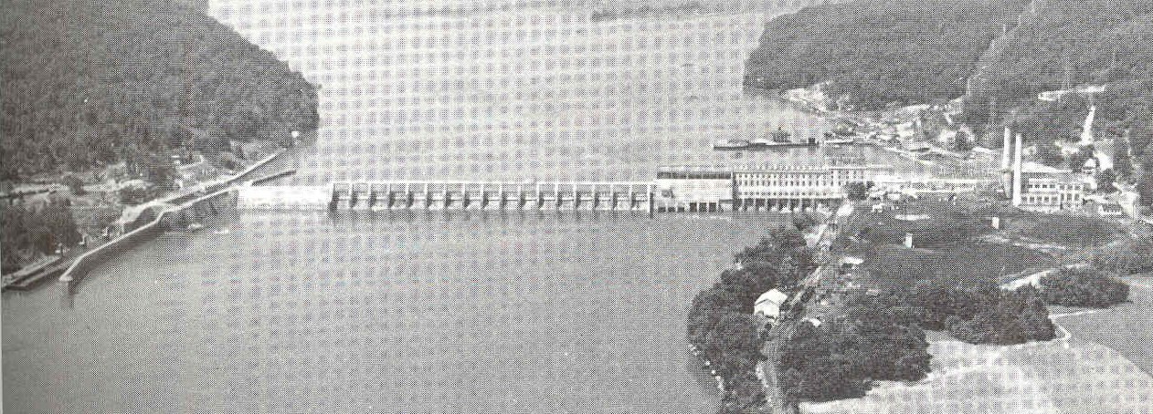
Hales Bar Dam era (1905–1913)
Work on Hales Bar Dam, an early hydroelectric project by the Chattanooga and Tennessee River Power Company to tame the river gorge, brought thousands of workers to the area. Haletown and Guild grew rapidly to house them: boarding houses, small stores, and worker cottages went up to serve the construction camps. A third worker village, Ladd, grew up on the south bank of the river opposite Guild, connected to the north-bank camps by a narrow access tunnel under the dam itself. The dam was completed in 1913. (Ladd on the Tennessee River should not be confused with Ladds Cove, a separate place at the Battle Creek headwaters near Monteagle, on the southern slope of the Cumberland Plateau.)
Guild and the dam engineer
The Guild post office opened on August 11, 1906, named for Josephus Conn Guild Sr., the engineer who led the dam's construction. Guild died in 1907 while the project was still underway. The community that grew around the post office provided housing and services for the dam workforce.
After the dam
Once Hales Bar Dam was finished in 1913, the construction workforce dispersed, and Haletown and Guild settled into their role as small river-frontage communities. The Guild post office operated continuously through this transition, moving to Haletown in the 1940s after TVA renovations at the dam displaced its original location. TVA had purchased the dam from the Tennessee Electric Power Company in 1939 as part of the utility consolidation that created the agency's power system. TVA could never fully fix the persistent leaks through the karst limestone beneath the dam, and after decades of grouting and patching, replaced Hales Bar with the new Nickajack Dam downstream in 1967. The old reservoir was superseded by Nickajack Lake, which raised water levels around the former construction villages and submerged some of the older river-bottom parcels near Guild. Guild Elementary School, the last of the village-era schools, closed in the early 1970s; students were reassigned to Jasper Elementary.
The Marion Memorial Bridge, a four-span metal truss bridge built in 1929, carried U.S. 41, U.S. 64, and U.S. 72 over the Tennessee River at Haletown and served as the eastern gateway into Marion County from Chattanooga for eight decades. The old bridge closed to traffic on January 9, 2012, ahead of blasting for the footings of its replacement; a new four-lane steel girder bridge opened just downstream in November 2014, and demolition of the 1929 truss followed in 2015.
Present day
Today Haletown and Guild are rural unincorporated communities within the Chattanooga metropolitan area, with a mix of long-time families and newer lakeside homes. The former Hales Bar powerhouse has been repurposed as an event space that hosts ghost tours and seasonal events. Serodino, Inc., founded in 1933, operates an inland shipyard at Haletown, building and repairing towboats, excursion boats, and barges. The area is served by Chattanooga's EPB fiber-optic internet.
Landmarks and features
- Former Hales Bar Dam powerhouse (event space, ghost tours)
- Nickajack Lake waterfront
- Serodino, Inc. shipyard
- Rankin's Ferry historical site (former crossing between Guild and Shellmound)
- US-41/US-64/US-72 junction (Marion Memorial Bridge replacement, 2014)
Related
Hale's Bar construction village (1905 to 1913) →
Hales Bar Dam engineering →
Transportation history →