Last updated: April 23, 2026
Marion County's waterfalls occur almost exclusively along the Cumberland Plateau escarpment, where small streams reach the edge of the sandstone caprock and drop over the rim into the softer Mississippian limestone and shale below. The county's flat-bottomed coves and valley floor produce few falls; instead, waterfalls cluster along the plateau rim from the Foster Falls / Denny Cove vicinity near the Grundy County line southward along Walden Ridge into the Tennessee River Gorge. This page consolidates what is known about the named falls in and immediately adjacent to the county. Some of them, especially the plateau-rim wet-weather falls, run only after significant rain.
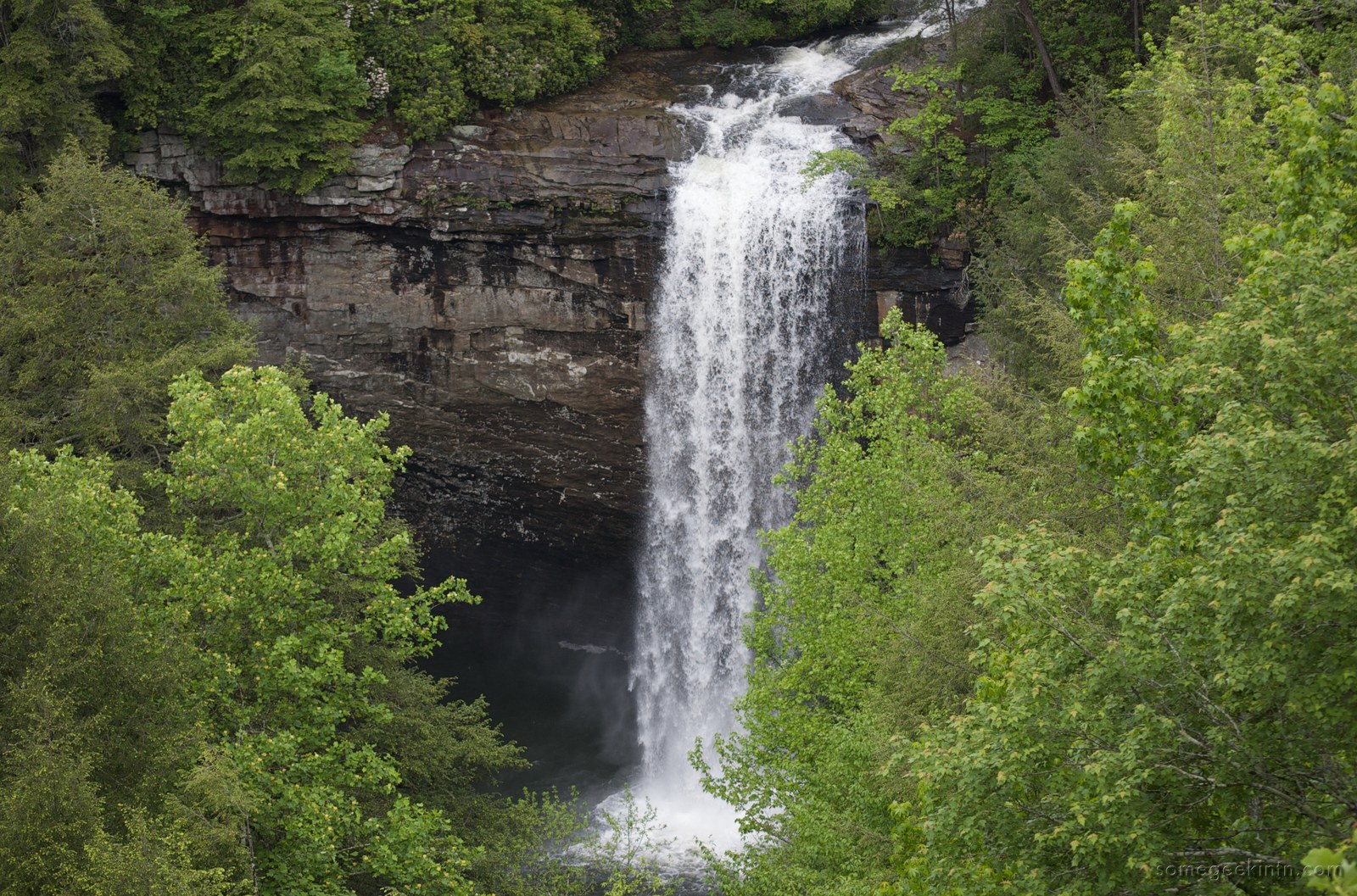
Foster Falls
Foster Falls is the tallest and best-known waterfall in the Marion County portion of South Cumberland State Park. Little Gizzard Creek drops approximately 60 feet over the sandstone rim of the plateau into a plunge pool at the base of a sandstone amphitheater. The trailhead at Foster Falls is a popular access for hikers and climbers; the Fiery Gizzard Trail begins here and continues north toward Tracy City in Grundy County. For detailed history, trail, and climbing coverage see the dedicated Foster Falls and Denny Cove page. Foster Falls is accessible year-round; flow is heaviest from late autumn through spring.
Denny Falls
Denny Falls is a 70-foot plateau-edge waterfall in Denny Cove, the 685-acre South Cumberland State Park unit a short distance north of Foster Falls. Denny Cove was acquired in 2016 by the Southeastern Climbers Coalition and the Access Fund for $150,000 and dedicated as part of the state park in 2017. A 2.7-mile round-trip trail leads from the parking area to the base of Denny Falls, passing climbing walls along the gorge rim. The fall runs year-round but is heaviest during wet periods; low summer flow reduces it to a trickle. For cove acquisition and climbing detail see Foster Falls and Denny Cove.
Laurel Falls
Laurel Falls, confusingly also referred to as Laurel Falls of Denny Cove in some sources, is a plateau-edge waterfall within Denny Cove's broader drainage. It is smaller than Denny Falls proper but attractive during spring bloom because of the mountain laurel (Kalmia latifolia) that lines the cliff top. Access is via the Denny Cove trail network. Several other Tennessee waterfalls share the "Laurel Falls" name, including the well-known falls in the Great Smoky Mountains; this page refers only to the Marion / Grundy county boundary waterfall in the Denny Cove unit.
Julia Falls
Julia Falls is a wet-weather waterfall on the Tennessee River Gorge rim above Prentice Cooper State Forest, visible from the Julia Falls Overlook along the Cumberland Trail's Signal and Edwards Points segment. The fall plunges over the Pennsylvanian sandstone caprock into the gorge below during periods of substantial rain; in dry months the falls vanish. The overlook, reached on foot from Signal Point via the Cumberland Trail, offers one of the most photographed long-distance views of the Tennessee River Gorge and is technically just across the line in Hamilton County but frames the Marion County side of the gorge. The overlook is covered in more detail on the overlooks page.
Ranger Creek Falls
Ranger Creek Falls is a plateau-edge waterfall in Prentice Cooper State Forest on the Marion / Hamilton boundary, accessible via a moderate bushwhack from the interior forest roads. Ranger Creek drains a portion of the plateau before dropping off the rim into the gorge. Seasonal flow; not a developed recreation site. The trail system does not provide signed access; the falls are known primarily to local hikers and the Tennessee Cave Survey's cross-referenced records.
Lesser-known and wet-weather falls
A number of smaller or less-publicized waterfalls exist along the plateau rim within or immediately adjacent to Marion County, including several in the tributary drainages of Mullins Creek, Suck Creek, and the upper Battle Creek watershed. Most run only after heavy rain. Because these falls are typically on private land or within the Prentice Cooper State Forest interior, access is limited and many are not signed. The Tennessee State Parks "Fall Creek" guide, the Sherpa Guides Cumberland Plateau volume, and the Tennessee Landforms online atlas all include additional wet-weather falls on the Marion side of the escarpment that are not individually named here.
Why so many plateau-edge falls?
The same geology that produced the Cumberland Plateau escarpment produces the waterfalls: Pennsylvanian sandstone, resistant to erosion, caps the plateau; softer Mississippian limestone and shale below erode more quickly. Streams crossing the rim encounter the abrupt transition from hard to soft rock, and the resulting knickpoint migrates slowly upstream as the plateau edge retreats. In Marion County the escarpment is more than 1,200 feet high in places, and small streams cutting through the rim generate vertical drops that are often disproportionately large compared to the catchments feeding them. For the geologic context see the geology page. Seasonality matters: most Marion County plateau-edge falls are at their most dramatic in winter and early spring when runoff is highest; summer flows are substantially reduced even on the perennial falls.
Visiting safely
The sandstone and limestone around the plateau-rim falls in the county are often wet, moss-covered, and undercut. Fatalities and serious injuries have occurred at plateau waterfalls across the region, typically from unroped climbing or scrambling above the lip. All of the developed falls, Foster, Denny, Julia via the Cumberland Trail, are accessed via signed trails that keep visitors a safe distance from the most dangerous edges. Off-trail exploration to less-developed falls is not recommended without local guidance. Swimming is permitted at the plunge pool below Foster Falls, but caution is advised because the water is cold year-round and the base of the falls can have hidden submerged rocks and logs.
Related
The Marion County hiking & trails hub →
About Foster Falls and Denny Cove →
About Marion County overlooks →
About the Cumberland Trail →
About Prentice Cooper State Forest →
About Marion County geology →
Sources
- Wikipedia — Fiery Gizzard Trail (runs to Foster Falls)
- Wikipedia — South Cumberland State Park (Foster Falls is the park's tallest)
- Tennessee State Parks — South Cumberland State Park
- Land Trust for Tennessee — Denny Cove, Marion County
- Friends of South Cumberland — park overview
- Tennessee Landforms online atlas
- Sherpa Guides — Lower Cumberland Plateau (chapter on Sequatchie Valley)