Last updated: April 23, 2026
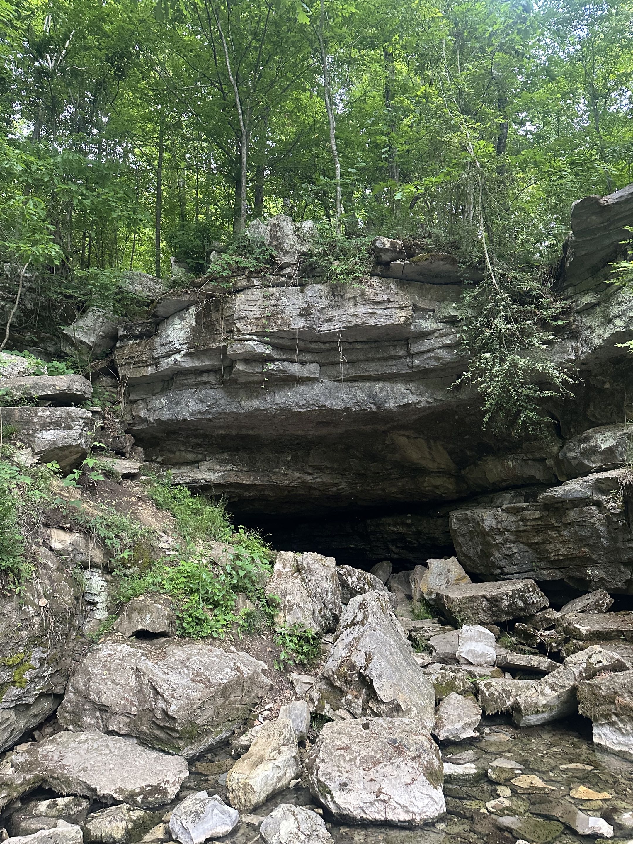
Marion County lies at the northern edge of the TAG cave region, shorthand for the corner where Tennessee, Alabama, and Georgia meet. TAG is the densest cave-bearing landscape in the United States: tens of thousands of documented caves cluster in the Mississippian limestone that underlies the southern Cumberland Plateau, the Sequatchie Valley, and the Sand Mountain / Lookout Mountain country south of the Tennessee River. Marion County contains hundreds of individually mapped caves and is among Tennessee's top counties by cave density. This page surveys the county's major caves and the broader karst setting that produced them; the geology page places the caves in their stratigraphic context.
Why so many caves?
The caves of Marion County are almost all in Mississippian limestone, 320 to 340 million years old, which underlies the Pennsylvanian sandstone caprock of the Cumberland Plateau. Rainwater acidified by soil CO2 enters the rock through fractures and sinkholes, slowly dissolving passageways along bedding planes and joints. Over millions of years, those passages enlarge into horizontal trunk conduits at the water table and into vertical shafts where water drops from the surface. The result, across TAG, is a three-dimensional network of caves that can extend for miles beneath the surface and hold rivers, lakes, deposits of gypsum and aragonite, and ecosystems of blind invertebrates and vertebrates adapted to eternal dark.
Marion County's cave density is amplified by two features. First, the Sequatchie Valley concentrates karst activity by exposing limestone at elevations where water can still drain downward to the Tennessee River, so the county has some of the most vertically developed cave systems in the region. Second, the Tennessee River Gorge gives water more than a thousand feet of potential drop between the plateau surface and the river, which drives deep and rapid cave development along the gorge walls. Several of the county's most significant caves have formed specifically because of the gorge's proximity.
Nickajack Cave
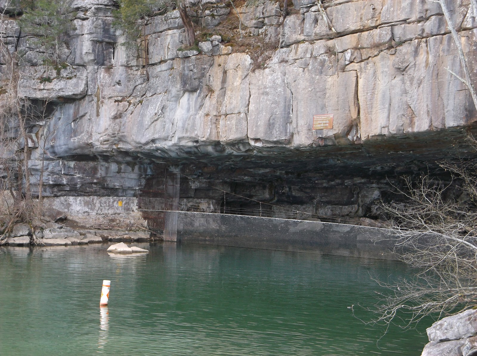
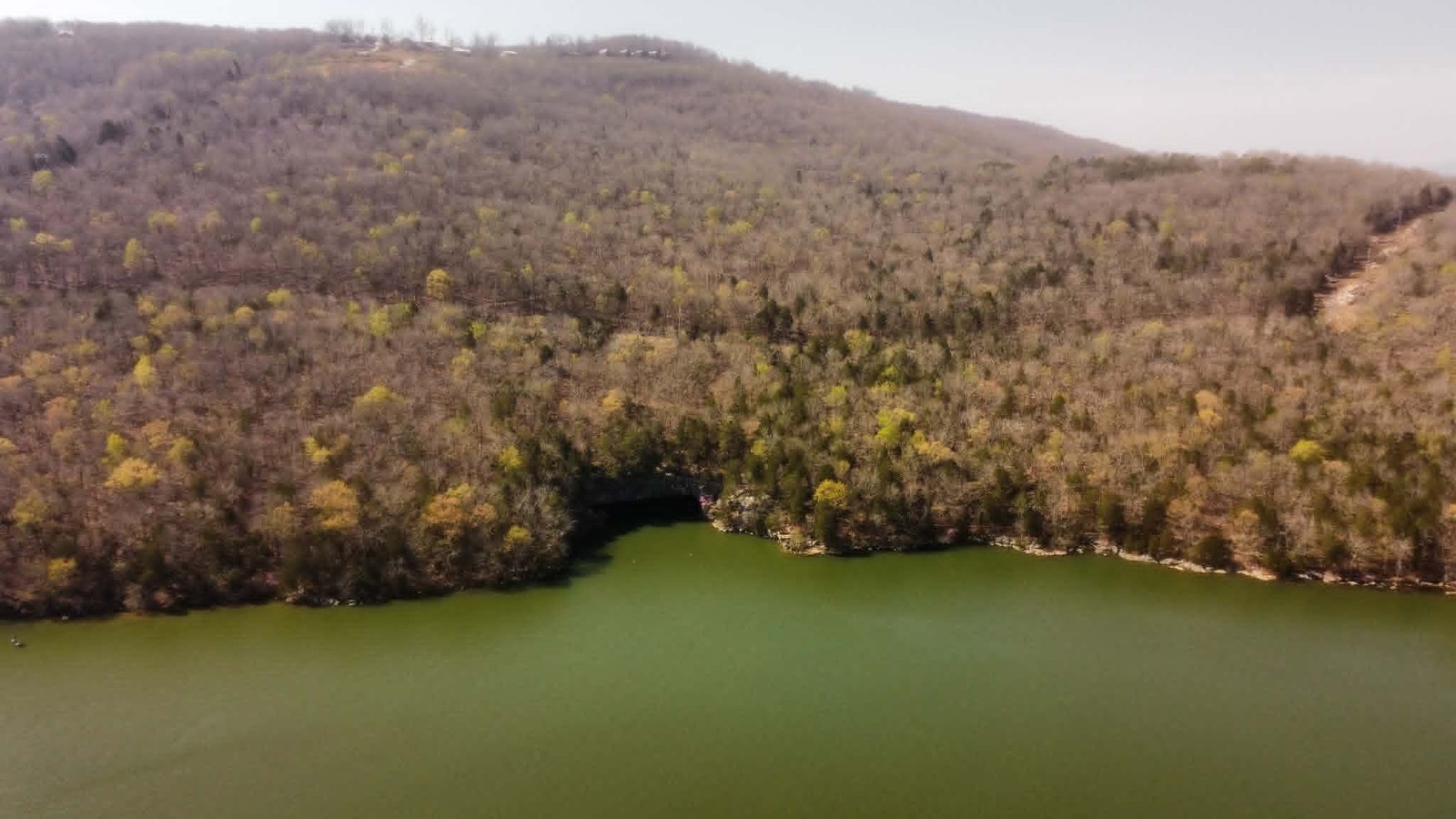
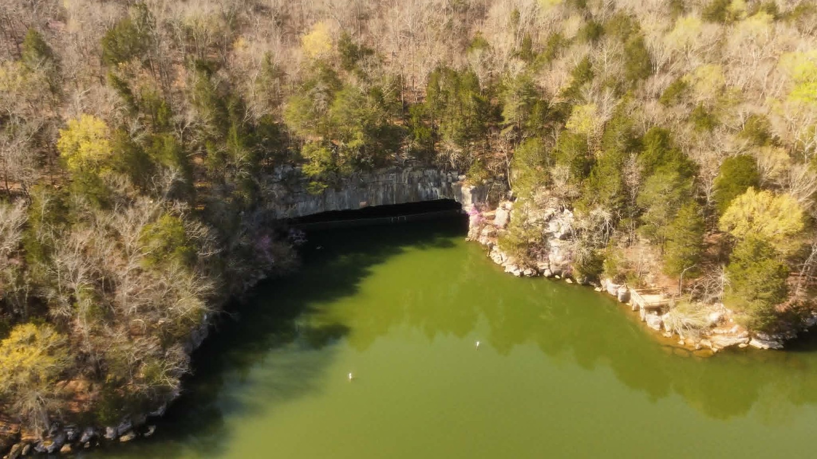
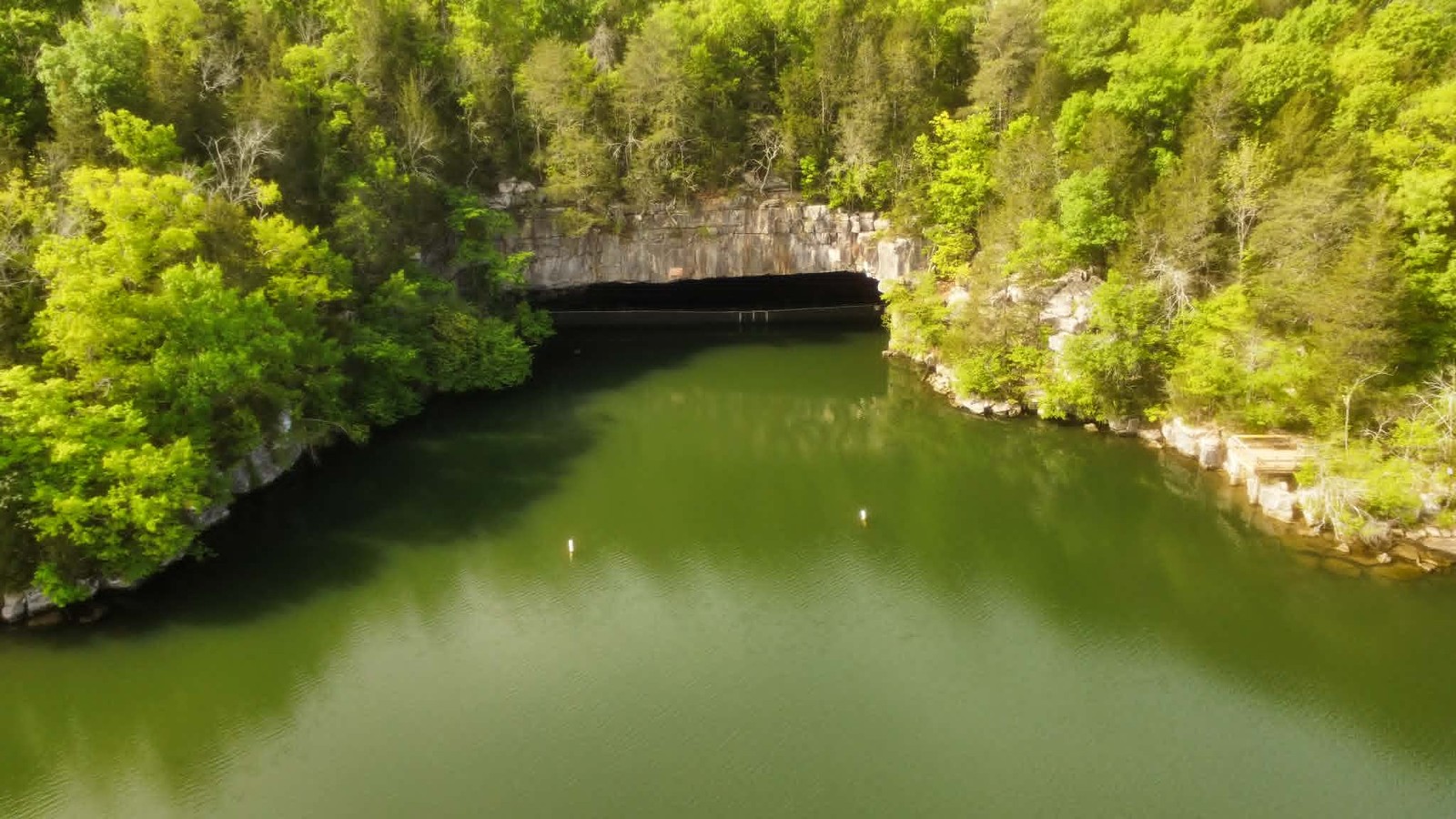
Nickajack Cave is Marion County's best-known cave and one of the largest cave entrances in the southeastern United States. Its original opening, at the base of the Tennessee River Gorge near Shellmound, was 140 feet wide and 50 feet tall; since Nickajack Dam raised the lake level in 1967, the lower 25 to 30 feet of the entrance has been submerged, reducing the visible opening to roughly 20 to 25 feet above water. Before flooding, the entrance passage extended about a quarter mile into the cave along a waist-deep stream, reaching interior chambers that were a regional tourist destination from the 1870s through the 1940s. The cave has served as a Cherokee refuge and Lower Town site, a saltpeter mine during the War of 1812 and Civil War, a prohibition-era hideout, and, briefly in 1967, the site of Johnny Cash's personal spiritual reckoning. Full detail lives on the dedicated Nickajack page.
Ecologically, Nickajack Cave is the county's most important cave. It houses a maternity colony of federally endangered gray bats (Myotis grisescens) estimated at more than 100,000 individuals each summer. The 1981 gating of the entrance by TVA ended decades of uncontrolled access that had been disturbing the roost, and the Maple View observation platform now provides visitors with dusk emergences between late April and early October. The 1967 flooding of the cave's lower passages destroyed habitat for two cave-obligate invertebrates, the pseudoscorpion Microcreagris nickajackensis and the ground beetle Pseudanophthalmus nickajackensis, both presumed extinct, a direct biological cost of the dam that made the gray bat protection possible.
Sequatchie Cave
Sequatchie Cave, at the community of Sequatchie in the lower Sequatchie Valley, is the type locality for more cave-obligate species than any other cave in Marion County and is protected as the Sequatchie Cave State Natural Area by the Tennessee Department of Environment and Conservation. The cave is home to the federally endangered Royal Snail (Marstonia ogmorhaphe), a freshwater gastropod under 5 millimeters in size known worldwide only from two sites: Blue Spring (Jasper's water supply) and Sequatchie Cave's Owen Spring Branch, four miles apart. The cave is also the type locality for the Sequatchie Caddisfly (Glyphopsyche sequatchie), the Blowing Cave beetle (Pseudanophthalmus ventus), and the cave millipede Scoterpes ventus. Because the caddisfly and the two terrestrial obligates are known from only a handful of nearby springs, the Sequatchie Cave system is one of the most significant aquatic and cave biodiversity sites on the southern Cumberland Plateau. For deeper treatment see the endemic species page.
Blowing Cave
Blowing Cave, in the Sequatchie Valley north of Jasper, takes its name from the steady current of air that issues from its entrance, cool in summer and warm in winter as the cave's interior temperature, roughly equal to the local mean annual air temperature, differs from the outside. The cave is the type locality for the Blowing Cave beetle and has been used for decades as a research site for studying cave climate, microbial ecology, and cave invertebrate distribution. Access is limited to permit and research use; the cave is on private land, and its owners have historically cooperated with the Tennessee Cave Survey and university biology programs.
Russell Cave
Russell Cave, the largest and most archaeologically significant cave in the immediate region, lies just across the Tennessee state line in Doran's Cove, Jackson County, Alabama, a few miles southwest of Marion County. It is designated a National Monument and protected by the National Park Service. Russell Cave contains a nearly continuous archaeological record of human occupation from approximately 10,000 B.C.E. to about 1,500 C.E., one of the longest sequences of any cave shelter in the eastern United States. The cave was first excavated in 1956 by a crew of South Pittsburg coal miners working for the Smithsonian. Although it is not in Marion County, Russell Cave is part of the same karst system and the same prehistoric cultural landscape, and the record there informs interpretation of Marion County sites along the Tennessee River. The full story of the dig and the valley's first peoples is told on the Russell Cave and In the Beginning history pages.
Other Marion County caves
Beyond the four caves above, Marion County hosts a long tail of smaller documented caves, most of them in private ownership or on state and federal forest land. Representative systems include:
Aetna Cave, on Aetna Mountain along the Tennessee River Gorge's north rim, a formerly commercial show cave whose entrance has since been closed. Julia Falls Cave, a small sandstone-rockhouse shelter cave along the Cumberland Trail above the Tennessee River Gorge; despite its name, it is a sandstone shelter rather than a true karst cave. Castle Rock Cave, on the plateau near Foster Falls, a horizontal-passage limestone cave used as a climbing-area reference point. Haletown Cave, a short limestone passage near the old NC&StL right-of-way along the south bank of the river. Pryor Cove Cave, draining the cove of the same name near Jasper; a tributary to the Little Sequatchie karst network. Running Water Cave, a small cave near the historic Cherokee town of Running Water. Mullins Cove Cave, in the north-bank cove opposite the gorge. None of these caves is open to the public without permission from the landowners or the relevant managing agency; the entrance access, bat sensitivity, and safety hazards of most unprotected caves in the county make independent visits inadvisable even when access is theoretically possible.
Caving organizations
Serious cave mapping and monitoring in Marion County is carried out primarily by the Tennessee Cave Survey (TCS), a project of the National Speleological Society that catalogs caves statewide and maintains the master database. The Survey's published figures have long given Tennessee more than 10,000 documented caves statewide, more than any other U.S. state, with TAG and the southern Cumberland Plateau as the densest concentrations. The Sewanee Mountain Grotto, the Chattanooga Grotto, and the Nashville Grotto of the National Speleological Society all include Marion County caves in their regional projects. University biology, hydrology, and geology programs at Tennessee Tech, UT Chattanooga, UT Knoxville, and Auburn use Marion County caves for field teaching and research, and USGS Water Science Center projects routinely rely on cave-spring data from the Sequatchie Valley and gorge tributary caves. For the County's cave roster, the authoritative source remains the TCS file.
White-nose syndrome
White-nose syndrome (WNS), a fungal disease caused by Pseudogymnoascus destructans, was first confirmed in Tennessee in 2010. It has devastated several North American bat species and reached the TAG region shortly after. Gray bats, the endangered species that roosts in Nickajack Cave, are less susceptible than the most affected species (northern long-eared bat, little brown bat, tricolored bat), but monitoring of the Nickajack colony has continued through TVA and USFWS. Annual bat counts have fluctuated since WNS detection; whether the Nickajack summer colony remains at the historic 100,000-plus level or has been reduced is an active monitoring question. Access to key bat caves in Marion County is restricted during winter hibernation and summer maternity to minimize stress and pathogen spread.
Related
About Nickajack Cave, Lake, and Dam →
About Marion County geology →
About endemic and notable species →
About Marion County fauna →
Sources
- Wikipedia — TAG Corner (caving region)
- Wikipedia — Nickajack Cave
- Wikipedia — Russell Cave National Monument
- National Park Service — Russell Cave National Monument
- TDEC — Sequatchie Cave State Natural Area
- Tennessee Cave Survey
- National Speleological Society
- U.S. Fish & Wildlife Service — Gray Bat
- White-Nose Syndrome Response Team
- USGS SIR 2024-5089 — Karst groundwater flow paths in Little Sequatchie and Pryor Cove