Last updated: April 22, 2026
- Type: Unincorporated community
- Location: Northwestern Marion County, along Interstate 24 at the head of the Battle Creek drainage, on the lower slopes of the Cumberland Plateau
- Notable for: Bell-detachment Trail of Tears campsite (October 1838); a karst cave system explored in 1958
Setting
Martin Springs is a small community in northwestern Marion County, along Interstate 24 as the highway climbs from the Sequatchie Valley floor up to Monteagle Mountain. Valleys and narrow benches cut through the area, sloping up toward the top of the Cumberland Plateau. Chattanooga is roughly 40 miles to the east. The community is primarily residential and rural, with a scattering of small farms and homes strung along the valley roads and the I-24 frontage.
Hydrologically, Martin Springs is the head of Battle Creek. The creek rises here from springs at the base of the plateau, then flows south through Battle Creek cove and on to the Tennessee River near South Pittsburg. The "springs" in the community's name refer to this collection of headwater seeps. The “Martin” half of the name follows the standard Tennessee pattern for such places: an early landholder's surname attached to a prominent natural feature on or near the tract. Martin surnames appear in the 1820s and 1830s Marion County tax rolls. The primary 19th-century documentation of the site centers on its role as a Trail of Tears camp rather than on its settler ownership.
Long before the Bell detachment camped at the springs, the head of Battle Creek and the adjacent plateau benches fell within a long arc of Indigenous use. The Cumberland Plateau and the upper Sequatchie corridor carried Archaic, Woodland, and Mississippian occupation over roughly ten thousand years, and by the 18th century this slope was part of the Cherokee homeland, used in particular by the Chickamauga (Lower) Cherokee as a travel and hunting corridor between the Lower Towns on the Tennessee River and the Overhill country to the northeast. The 1838 encampment at Martin Springs was therefore a forced departure from a landscape the Cherokee had held for generations. The Cherokee Nation, today a sovereign nation headquartered in Oklahoma, traces ancestry through the families whose footpaths ran along these springs.
The Bell detachment, October 1838
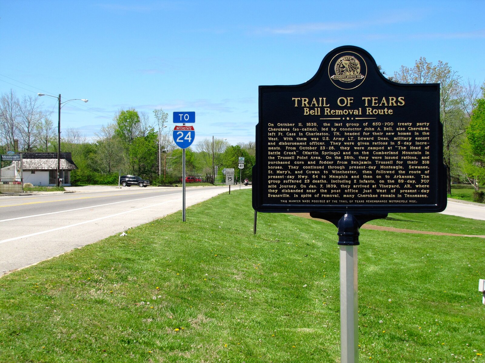
Martin Springs is one of a small number of documented Cherokee removal campsites in Marion County. On October 11, 1838, John Bell began escorting a group of roughly 660 Cherokee, members of the so-called "Treaty Party" who had accepted the 1835 Treaty of New Echota, westward from their gathering camp near Fort Cass (in present-day Bradley County) toward Evansville, Arkansas. The detachment's route, known as the Bell Route, passed through the Sequatchie Valley and over the Cumberland Plateau.
From October 23 to October 26, 1838, the detachment was encamped at the Head of Battle Creek, at Martin Springs, along with a smaller group on the Cumberland Plateau above at Trussell Point. Rations were issued on the 26th, and the detachment purchased corn and fodder from a local settler, Benjamin Trussell, to feed their 318 horses. From Martin Springs they continued over the plateau and on toward Arkansas. The stop is one of the best-dated Trail of Tears events that took place inside Marion County.
This was not a chosen migration. The Bell detachment and the larger contemporaneous Cherokee groups were travelling under the terms of a forced removal mandated by the Treaty of New Echota and enforced by the U.S. Army, which had rounded up most of the Cherokee population into stockades before marching them west. The Head of Battle Creek camp at Martin Springs is one marker in that longer, broader forced displacement.
Martin Springs Cave
The springs at the community's head are the surface expression of a substantial cave system running under the base of the plateau. In July 1958, members of the Florida Speleological Society explored the cave with diving gear and documented an underwater passage about 15 feet in diameter running some 250 feet from the spring entrance into a room roughly 50 feet across and 40 feet high. The cave is known for about 550 feet of passage and reaches depths of about 50 feet, making it one of the longer underwater caves yet documented in the Marion County portion of the Cumberland karst.
The cave is not open to the public. Responsible cave exploration on the plateau requires coordination with landowners and the Tennessee Cave Survey; several Marion County caves, including this one, hold significant populations of endangered bats and Tennessee cave salamanders.
Martin Springs School
Before the mid-20th-century consolidation of Marion County schools, Martin Springs had its own one-room community school, referenced in county records as Martin Springs School. It was one of roughly 120 such small schools covered in the Marion County historical schools roster; it closed when bus service made it practical to attend larger consolidated schools in Kimball and South Pittsburg.
Present day
Today Martin Springs is a small, quiet residential community. It has no incorporated status, no commercial center, and no post office of its own. Interstate 24 passes through the community, which gives it a measure of connection to the larger region, but little stops here unless the people or the cave are the reason.
Related
Battle Creek (community) →
The Trail of Tears through Marion County →
Cherokee Lower Towns →
Historical schools of Marion County →
Fauna (cave-dwelling species) →