Last updated: June 3, 2026
- Physiographic province: Southern Appalachian Plateaus (Cumberland section)
- Dominant structure: Breached Sequatchie Anticline, a southwest-to-northeast fold
- Caprock: Pennsylvanian Gizzard and Crab Orchard Mountains group sandstones and conglomerates
- Valley floor: Ordovician and Silurian limestones and shales
- Gorge floor: Mississippian limestone exposed by Tennessee River downcutting
- Coal seams: Sewanee, Richland, and associated Pennsylvanian beds
- Elevation range: ~630 ft (Tennessee River at South Pittsburg) to over 2,000 ft (Monteagle area)
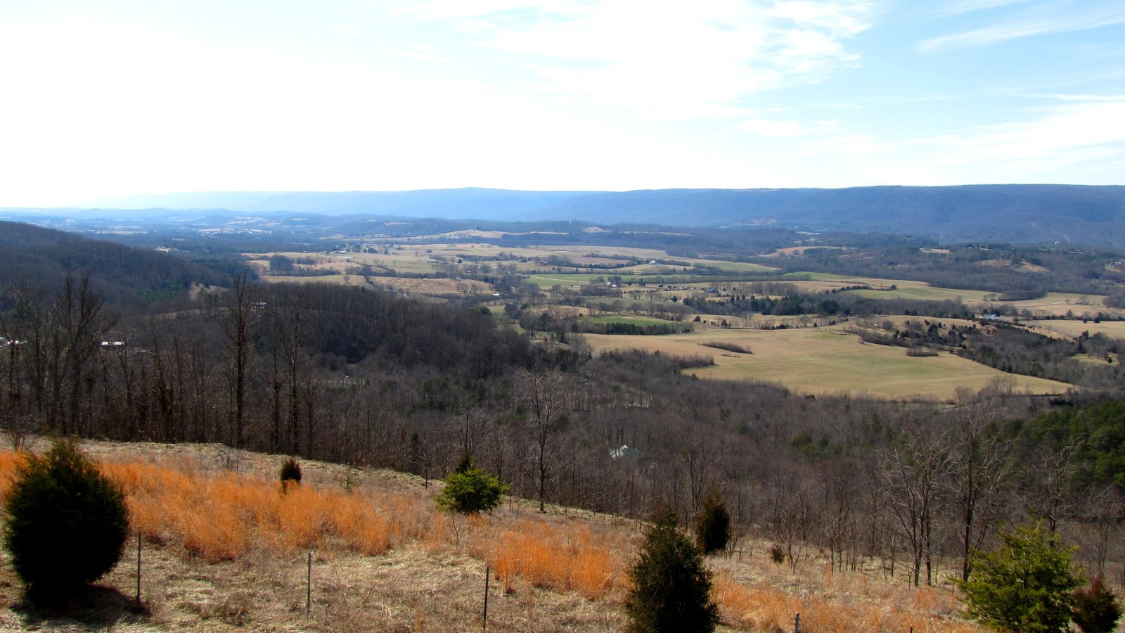
Marion County sits at the southern end of the Cumberland Plateau and contains some of the most dramatic geologic structure in Tennessee. The county's landscape is written by two features: the Cumberland Plateau escarpment, which rises as a sandstone wall around most of its perimeter, and the Sequatchie Anticline, a long upward fold in the plateau whose crest eroded away to leave the linear Sequatchie Valley. Where the Tennessee River cuts through the plateau along the county's southern edge, the Tennessee River Gorge exposes a third cross-section: a window into the older Mississippian limestone and shale beneath the plateau's Pennsylvanian caprock. Every other geologic feature the county is known for, its coal, its karst springs and caves, its waterfalls, its bluffs and overlooks, follows from that stratigraphic and structural setting.
Physiographic setting
Marion County lies within the Cumberland Plateau section of the Appalachian Plateaus physiographic province. To the east, across Walden Ridge in Hamilton County, lies the Ridge-and-Valley province; to the south, across the Tennessee River in Alabama, the same Appalachian Plateau pattern continues as Sand Mountain. The county therefore sits on the hinge between several large landforms: the plateau proper on the north and west, the Ridge-and-Valley to the east, and the river-cut sandstone mesa country of northern Alabama to the south. All three landscapes share the same underlying stratigraphy, the same sequence of Ordovician through Pennsylvanian rocks, but the pattern of folding and erosion produced very different surfaces. Marion County is one of the few places in Tennessee where all three can be seen from a single overlook.
Raulston and Livingood, writing the region's natural history in Sequatchie (1974), describe the Sequatchie country as an old peneplain, a once-mountainous surface worn low by erosion, within the larger Appalachian Plateau that runs from southern New York into central Alabama. North of West Virginia that upland is called the Allegheny Plateau and to the south the Cumberland Plateau; in the Sequatchie region it is known popularly as the Cumberland Mountains. The bold escarpment on the valley's eastern side, scientifically the Cumberland Front, took the popular name Walden Ridge as a memorial to one of the early Long Hunters who scouted the region; so straight and uniform is its crest, the authors note, that from a distance it resembles a giant, well-trimmed hedge.
Stratigraphy
The rock layers beneath Marion County, from youngest on top to oldest beneath, fall into three broad packages that correspond to the three surfaces the county displays: a Pennsylvanian sandstone and coal package forming the plateau caprock, a Mississippian limestone and shale package forming the gorge walls and the upper parts of the Sequatchie Valley floor, and an Ordovician and Silurian limestone and shale package exposed in the lower part of the Sequatchie Valley and below the gorge.
The plateau caprock belongs to the Pennsylvanian Gizzard Group and Crab Orchard Mountains Group. The Gizzard Group includes the Raccoon Mountain, Warren Point, Signal Point, and Sewanee Conglomerate formations: hard, cross-bedded sandstones, coarse quartz-pebble conglomerates, and interbedded coal seams. Above the Gizzard Group, where preserved, sit the Whitwell Shale and overlying Crab Orchard Mountains sandstones, which contain the higher coal seams. These Pennsylvanian rocks record a succession of deltaic and coastal environments; the conglomerate beds, bouldery in places, mark the shorelines of sediment-choked Carboniferous seas. The same quartz-pebble beds are visible in plateau-rim outcrops across the county, and the old Warren Point Sandstone quarry names and the Sewanee Coal seam name both come from plateau-town localities within and immediately adjacent to Marion.
Below the Pennsylvanian caprock lie the Mississippian limestone and shale formations: the Pennington, Bangor, Monteagle, Saint Louis, Warsaw, and Fort Payne. These form the recessed slopes below the sandstone rim throughout the plateau edge and make up the gorge walls wherever the Tennessee River has cut deep enough to expose them. The Mississippian limestones are the host rocks for the county's karst features: the caves, springs, and sinkholes that define the valley floor and the plateau rim. Below the Mississippian, the Ordovician and Silurian rocks, Chattanooga Shale, Rockwood, Sequatchie, Chickamauga, and older units, form the bottom of the Sequatchie Valley and lie beneath the younger cover.
The Sequatchie Anticline
The Sequatchie Valley is not a river valley carved into a pre-existing plateau. It is a breached anticline: a long, narrow upward fold in the plateau rocks whose crest eroded faster than its flanks, leaving a trough between two ridgelines that were once joined across the top. The anticline is one of the longest structural features in the southern Appalachians, stretching from the vicinity of Bridgeport, Alabama northeastward past Crossville, Tennessee, for roughly 150 miles. The Tennessee portion that corresponds to the visible valley is about 65 miles long, and Marion County contains its southern end, where the fold plunges beneath the Tennessee River and disappears beneath younger sediments.
Work by R. C. Milici and others has established that the Sequatchie Anticline is not just a simple fold but is thrust-faulted on its northwestern flank. The thrust ramps upward from the Lower Cambrian Rome Formation, cuts through the overlying Ordovician and Mississippian rocks, and flattens into a detachment within weak shale and coal beds in the Pennsylvanian section. The fold geometry is classic "fault-bend" style: a long, near-flat detachment below, a steep ramp upward, and a second flat higher in the stratigraphy. The structure formed during the late Paleozoic Alleghanian orogeny, when the African plate's collision with North America pushed a stack of thrust sheets westward into the plateau rocks. The Sequatchie Anticline is the southernmost of the large folds in the Tennessee plateau and is the westernmost expression of that tectonic deformation before the rocks flatten out into the Interior Low Plateaus farther west.
The Cumberland Plateau escarpment
The escarpment that surrounds Marion County on its plateau edges is a retreat face: a cliff line slowly backing away from the valley floor as the softer Mississippian rocks beneath the sandstone caprock erode out from under it. Blocks of caprock calve off at the rim when the underlying support gives way, and the resulting talus ramps of sandstone blocks are visible at the base of most plateau cliffs in the county. This slow undermining is responsible for the distinctive bench-and-cliff topography that characterizes the plateau rim: a steep upper cliff of Pennsylvanian sandstone, a recessed middle slope where the softer shales and limestones have weathered back, and a lower bench where harder Mississippian limestone units temporarily resist erosion. Foster Falls, Denny Falls, Julia Falls, Laurel Falls, and most other Marion County waterfalls occur where a small stream crosses the caprock rim and drops down this bench-and-cliff sequence. For detail on individual falls, see the waterfalls page.
The escarpment is not a single continuous line. It is lobed and scalloped by the erosional work of streams cutting back into the plateau: Little Gizzard, Big Creek, Battle Creek, Suck Creek, Mullins Creek, and the tributaries of the Sequatchie River all have their own embayments in the rim. Each embayment creates a cove: a rounded, amphitheater-shaped valley with a flat-bottomed floor, steep sides, and a single narrow mouth where the stream exits. Marion County's collection of coves, Mullins Cove, Sweetens Cove, Battle Creek Cove, Ladds Cove, Pryor Cove, Running Water Cove, Doran Cove, and others, is a direct product of this headward-erosion process acting on a sandstone caprock over a softer substrate. Several of those coves host named Marion County communities that grew up on the flat-bottomed cove floors.
Coal
Marion County's Pennsylvanian stratigraphy contains several minable coal seams. The Sewanee Coal, named for its type locality on the plateau a few miles west of the Marion County line, is the most widely mined; the Richland, Castle Rock, and associated seams also underlie parts of the county. Commercial mining began in the valley at Battle Creek in 1854 and expanded during the British-capital industrial boom of the 1870s and 1880s, with Whitwell, Victoria, Orme, and the plateau mining towns developing around seam outcrops and convenient rail spurs. Inman and Palmer, east of the county line, continued the same pattern on the Walden Ridge side. Coal, coke, and the associated timber and ovens are covered in depth on the coal and coke page. The geology behind those mining districts, the seam thicknesses, roof conditions, and structural variation within the Pennsylvanian section, is summarized in USGS and Tennessee Division of Geology bulletins going back to the 1890s, and the 2003 Milici regional coal-resource assessment remains the reference for the county's remaining reserves.
The Pennsylvanian coal is not evenly distributed. Ancient compressional stresses, the same forces that folded the Sequatchie Anticline, squeezed the coal at some places into thick pockets or pods and at others pinched it out of the seam entirely, so that a bed rich at one outcrop can thin to nothing a short distance away. An early state survey gave a sense of the scale of what remained: in The Coal Resources of Tennessee (1959), Edward T. Luther estimated the recoverable reserves at roughly 47 million tons in Marion County, 44 million in Sequatchie County, and 22 million in Bledsoe County, the three counties of the Sequatchie Valley. These figures are reported in Raulston and Livingood's Sequatchie (1974).
Karst
The Mississippian limestone that underlies the Sequatchie Valley and much of the plateau is the host for Marion County's karst, the landscape of sinkholes, disappearing streams, springs, and caves produced by slow dissolution of soluble rock by weakly acidic groundwater. Sequatchie Cave, Nickajack Cave, Blowing Cave, and the several hundred other documented caves in the county are all limestone caves; the springs that rise at the Sequatchie Valley floor, including the Head of Sequatchie in Cumberland County to the north and Blue Spring and Owen Spring in Marion County proper, are karst resurgences carrying water that entered the plateau through sinkholes miles away. Because karst drainage does not respect surface watersheds, contamination entering a sinkhole on one side of the valley can surface at a spring on the other side with little attenuation. USGS Scientific Investigations Report 2024-5089 mapped karst flow paths in the Little Sequatchie and Pryor Cove watersheds and confirmed that the two systems are hydrogeologically linked beneath the valley floor. The valley's karst plumbing reaches beyond the county as well: the Sequatchie River itself rises from karst, where surface water sinking in Grassy Cove, an enclosed basin at the head of the valley, travels for miles beneath the mountains and resurfaces at the Head of Sequatchie, a connection a 1961 dye test confirmed and that is detailed on the Sequatchie River page. For a deeper treatment, see the caves page.
The Tennessee River Gorge and deep time
The Tennessee River's 26-mile crossing of the southern Cumberland Plateau between Chattanooga and the Alabama line is one of the deepest and most recent erosional features in the region. The river cut down through the sandstone caprock and into the underlying Mississippian limestone during the late Tertiary and Quaternary, dropping as much as 1,200 feet from the plateau surface to the current river grade. The canyon's hard, ledge-forming limestone units produced the historic rapids, The Suck, The Boiling Pot, The Skillet, The Frying Pan, drowned by Hales Bar Dam in 1913 and now beneath Nickajack Lake, at points where the river encountered particularly resistant beds.
Radiocarbon-dated deposits within and above the gorge preserve a record of major prehistoric floods. USGS Scientific Investigations Report 2017-5052 documented slackwater and overbank deposits along the gorge that date to floods in the first millennium before present, providing an independent benchmark for the 1867 flood's rarity. The gorge is therefore not just a scenic feature; it is a physical timeline of the Tennessee River's Quaternary behavior and the clearest window into the county's older stratigraphy. For a geographic treatment of the gorge, see the Tennessee River Gorge page.
Fossils
Marion County's Paleozoic rocks preserve a rich and well-studied fossil record. The Mississippian limestones on the Sequatchie Valley floor and in the gorge walls contain marine invertebrates: crinoids, brachiopods, bryozoans, corals, trilobites, and occasional fish and nautiloid remains, recording the warm tropical sea that covered the region 340 to 320 million years ago. The younger Pennsylvanian sandstones, conglomerates, and shales of the plateau caprock include plant fossils, lycopod bark impressions, fern fronds, and the seed-bearing strobili of Carboniferous forests, as well as trace fossils from coastal and delta-front environments. Coal seam partings preserve occasional insect and amphibian impressions. The oldest exposed rocks in the Sequatchie Valley, the Ordovician Chickamauga Group limestones, contain an older set of invertebrate fossils: trilobites, graptolites, and conodonts characteristic of the deep epicontinental seas of the early Paleozoic. No systematic county-level paleontological inventory has been compiled, but the Mississippian exposures in the gorge and along Suck Creek are regular collecting localities for Tennessee and Georgia paleontology courses.
Seismicity
Marion County sits on the southwestern edge of the Eastern Tennessee Seismic Zone (ETSZ), a diffuse region of small-to-moderate earthquakes that extends from northeastern Alabama through eastern Tennessee into southwestern Virginia. The ETSZ is not associated with a surface fault but with reactivation of basement structures at depth. Felt earthquakes in the low magnitudes are common across the zone each year; the April 29, 2003 Fort Payne, Alabama magnitude 4.6 event and the December 12, 2018 Decatur, Tennessee magnitude 4.4 event were both widely felt across Marion County. The county's largest historic event is the magnitude 4.7 shock of March 27, 1973, centered in Knoxville, which was felt throughout the Tennessee Valley. No fatal or structurally damaging earthquake is known from Marion County, but TVA operates a seismic monitoring network across the Tennessee Valley that feeds into the U.S. Geological Survey's Advanced National Seismic System, and Nickajack Dam is subject to the Corps of Engineers' dam-safety seismic review protocols.
Related
About Marion County caves →
About the Tennessee River Gorge →
About the Sequatchie Valley →
About Marion County waterfalls →
About Marion County coal and coke →
Sources
- Wikipedia — Cumberland Plateau
- Wikipedia — Sequatchie Valley
- Milici, R.C., "The Geology of the Sequatchie Valley Overthrust Block," University of Tennessee doctoral dissertation
- USGS Professional Paper 996 — Upper Ordovician and Silurian Stratigraphy in Sequatchie Valley
- USGS SIR 2017-5052 — Prehistoric floods on the Tennessee River
- USGS SIR 2024-5089 — Karst groundwater flow paths, Little Sequatchie and Pryor Cove watersheds
- TDEC — Tennessee Geological Survey
- Wikipedia — Eastern Tennessee Seismic Zone
- USGS — Earthquake Hazards Program
- J. Leonard Raulston and James Weston Livingood, Sequatchie: A Story of the Southern Cumberlands (Knoxville: University of Tennessee Press, 1974), chapter 2, "Visitors and the Land," pp. 16–20 (the peneplain framing, the Walden Ridge name, and the 1959 Luther coal-reserve figures).