Last updated: April 23, 2026
- Primary river: Tennessee River, commercially navigable via TVA locks
- Historic ferries: Rankin's Ferry (Guild to Shellmound, to the late 1920s); Betsy Pack's ferry at Jasper; Kelly's Ferry (Kelly's Ferry to Haletown, to 1952); South Pittsburg ferry (to 1981)
- Primary railroad: Nashville, Chattanooga & St. Louis Railway (NC&StL), merged into L&N in 1957, now CSX
- Primary interstate: I-24, completed through Marion County between 1962 and 1971
- US highways: US 41 (originally the Dixie Highway), US 41A, US 64, US 72, US 127
- Notable bridge: Shelby Rhinehart Bridge (SR-156 over the Tennessee River, 1981)
- General-aviation airport: Marion County Airport (Brown Field, APT), Jasper
Marion County's transportation story mirrors its geography. The Tennessee River and its gorge funneled early commerce; the rugged Cumberland escarpment channeled railroads and roads into a few passable corridors; and Monteagle Mountain, the long grade dividing the Sequatchie Valley from the Nashville Basin, has shaped every land route in and out of the county from the pre-statehood era to Interstate 24. Four successive layers are visible on the modern map: Cherokee and stagecoach trails along the river and over the mountain; the NC&StL Jasper, Inman, Pikeville, and Orme branch lines through the industrial era; the U.S. 41 Dixie Highway through the motor-court era; and Interstate 24 from 1962 forward. Each layer left physical traces still legible on the landscape.
The Tennessee River
The Tennessee River has been Marion County's most important transportation artery for most of the region's human history. Before European contact it was the backbone of Cherokee and earlier Mississippian travel and trade. In the Chickamauga era of the late 1700s the Lower Towns at Nickajack and Running Water sat directly on the river. After Anglo-American settlement the river carried produce, timber, and coal downstream to the Tennessee and Ohio valleys and beyond.
Steamboat navigation on the Tennessee River became commercially viable in the 1820s. The first steamboat to run regularly on the upper Tennessee, the Atlas, reached the Chattanooga reach in the late 1820s and ran through Marion County to the extent that water levels and rapids permitted. Nineteenth-century commercial steamboat traffic through the Marion County reach was always seasonal and always constrained by the low-water months and by the rapids inside the Tennessee River Gorge; most commercial traffic transshipped freight around the rapids rather than attempting them.
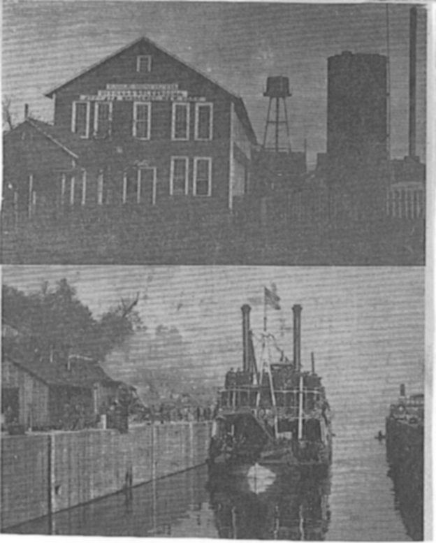
Navigation through the Marion County stretch was historically hazardous. The most feared obstacle was “The Suck,” a stretch of rapids, whirlpools, and sudden currents in the Tennessee River Gorge where the river bent sharply around the Cumberland Plateau. Below The Suck came a succession of shoals and rapids with period names that spoke to their reputation: Tumbling Shoals, the Kettle, the Suck Shoals, the Pot, the Skillet, and the Pan. The Suck cost boats and lives throughout the 19th century and was not tamed until Hales Bar Dam, completed in 1913, raised water levels and drowned the worst of the rapids. Hales Bar Dam, replaced by TVA's Nickajack Dam in 1967, made the entire Marion County river reach into a commercially navigable reservoir with modern locks. The 1863 Cracker Line operation used the same stretch of river, with the quartermaster steamer Chattanooga (built at Bridgeport by Arthur Edwards) shuttling rations and ammunition upriver from Bridgeport, Alabama to Kelly's Ferry Landing in Marion County for the relief of besieged Union forces at Chattanooga (see The Cracker Line).
The river remains active today as part of the TVA lock-and-dam system, carrying barge freight between the upper Tennessee Valley and the Ohio and Mississippi basins. Nickajack Lock, at the Nickajack Dam six miles downstream of the former Hales Bar site, handles the lockages into and out of the Marion County reach. Read more about “The Suck” rapids →
Historic ferries
Before modern bridges, ferries were the practical way to cross the Tennessee River in the Marion County gorge. At least four named ferries operated in the county across the 19th and 20th centuries.
Rankin's Ferry operated across the Tennessee River between Guild and Shellmound well into the late 1920s. It was the main local crossing in the era before modern bridges and served farmers, mail carriers, and commerce through the gorge. The Rankin's Ferry historical site can still be seen in the Guild area, though the ferry service ended as bridges took over during the late 1920s.
Kelly's Ferry, further east along the gorge near the mouth of the same-named community, operated from the early 19th century until 1952. The ferry was founded by John Kelly (1779–1845) and carried on by his descendants into the middle of the 20th century. Kelly's Ferry Landing is remembered as the river end of the Cracker Line supply operation of October 1863, when Union steamboats brought rations and artillery ammunition up from Bridgeport, Alabama to rescue the besieged Union forces at Chattanooga (see Kelly's Ferry). The ferry closed in 1952 as the 20th-century highway network finally provided viable alternatives. The Kelly's Ferry Cemetery, listed on the National Register of Historic Places in 2006, is the principal surviving landmark of the vanished ferry community.
At the county seat, Betsy Pack, daughter of Cherokee chief John Lowrey, operated a ferry on the Tennessee River near Jasper in the early 1800s. She also sold the 40-acre tract on which the town of Jasper was founded in 1819. Jasper's main north-south street, Betsy Pack Drive, is named for her. See her profile on the people page.
The South Pittsburg ferry ran at the foot of downtown South Pittsburg for more than 75 years, connecting the industrial town on the north bank to the farm communities of New Hope and beyond on the south bank. It was the last of the Marion County Tennessee River ferries to operate, surviving into the automobile era by roughly five decades. It was replaced in 1981 by the Shelby Rhinehart “Blue” Bridge.
Smaller ferries and skiff crossings also operated at various points along the Marion County reach, at places now submerged under Nickajack Lake. Moffat's Ferry and several unnamed family-operated crossings are referenced in the TNGenWeb Marion County community roster and in 19th-century newspaper notices. See the other communities roster page for additional named landings and riverside flag stops.
Railroads
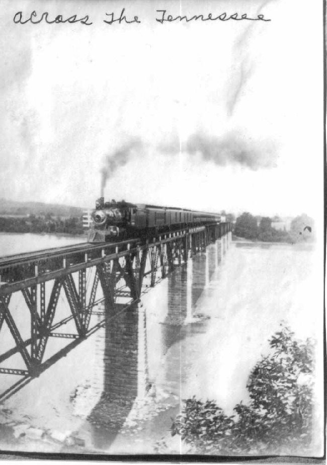
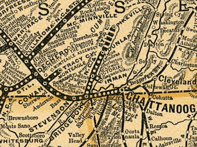
The Nashville, Chattanooga & St. Louis Railway (NC&StL) was the rail backbone of industrial Marion County. Its main line passed through the Sequatchie Valley and tied the coal, coke, iron, and cement operations at Whitwell, Victoria, Orme, Inman, Richard City, and South Pittsburg to national markets. The NC&StL was absorbed into the Louisville & Nashville Railroad in 1957 and later became part of CSX; portions of the historic route remain in service for freight. Read more about the NC&StL Railway →
The Pikeville Branch Railroad was a regional branch that ran north up the Sequatchie Valley from Marion County toward Pikeville in Bledsoe County. It served the coal operations of the upper valley and carried passenger and freight traffic into the 20th century. A dedicated spur branched off the Pikeville Branch at Copenhagen (Richard City) to serve the Dixie Portland Cement plant, tying Marion County's largest 20th-century manufacturer into the broader regional rail grid.
Passenger rail service to Marion County ended in the mid-20th century as highway travel took over. No passenger trains stop in the county today.
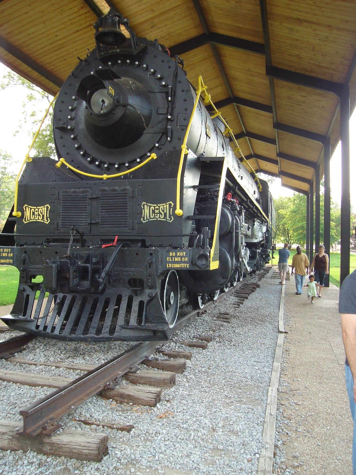
The NC&StL Railway
The Nashville, Chattanooga & St. Louis Railway, the main line that served industrial Marion County.
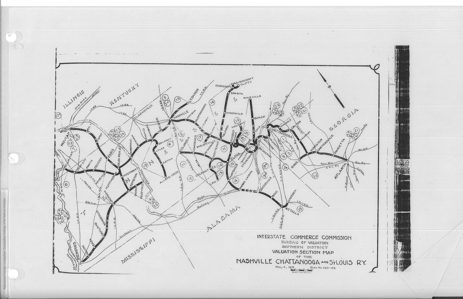
Railroads of Marion County
The full inventory: smaller branches, the Mountain Goat (Sewanee Mining) line, Condra Switch, industrial spurs, and the post-1985 abandonments.
Pre-statehood trails and stagecoach routes
The earliest overland routes through Marion County were Cherokee trails. The Great South Trail ran down the Tennessee River and into north Alabama, passing through the Lower Towns at Nickajack and Running Water. A parallel plateau trail crossed Monteagle Mountain along what is now approximately the U.S. 41 alignment, descending to the valley floor near Martin Springs. Cherokee leaders, traders, missionaries, and surveyors used these routes throughout the pre-statehood period.
The 1794 Nickajack Expedition under Major James Ore used the plateau trail to approach the Lower Towns from the north, destroying Nickajack and Running Water and ending Chickamauga Cherokee resistance in the region (see Cherokee Lower Towns). The same plateau grade was used by the 1838 Bell detachment of the Trail of Tears, the forced removal of Cherokee families west. A period Bell Route historical marker on U.S. 41 at Monteagle records the detachment's camp near Martin Springs at the head of Battle Creek.
Stagecoach service on the plateau route began in the early 1830s, carrying passengers and mail between Nashville and Chattanooga along what became the Dixie Highway corridor. The stage road down the eastern face of Monteagle Mountain was steep enough that loaded coaches often had to be partly unloaded and the teams rested at the top; the same grade would later challenge motor-truck operators on U.S. 41 and I-24. Stagecoach service was supplanted by rail after the 1854 opening of the Nashville & Chattanooga Railroad through Cowan, Tennessee, and through the Marion County Jasper Branch from 1867 forward.
Roads and US highways
By the early 20th century the plateau and valley routes had been formalized into numbered U.S. highways. The U.S. 41 Dixie Highway subpage traces the full Marion County corridor; the summary below lists the main routes that cross the county:
- US 41 / US 41A: the historic Dixie Highway corridor from Chattanooga over Monteagle Mountain toward Nashville, the primary overland route through the county before I-24
- US 64: an east-west route crossing the southern end of the county near South Pittsburg and the Alabama line
- US 72: an east-west route connecting Chattanooga across the Tennessee River through the southern end of the county toward north Alabama
- US 127: a north-south route that runs up the Sequatchie Valley and connects Marion County with the plateau
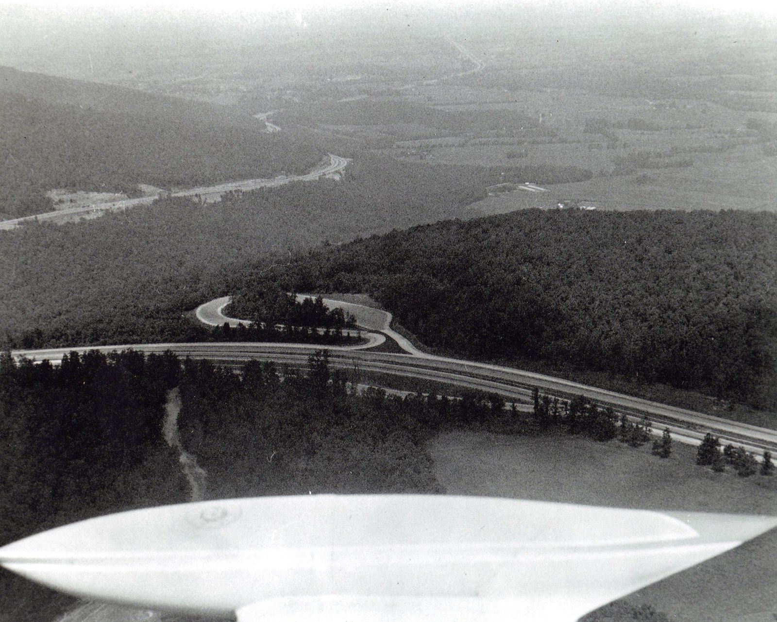
Of these, the Monteagle Mountain grade on US 41 (and later I-24) has been a defining geographic bottleneck. The climb out of the Sequatchie Valley onto the Cumberland Plateau is long, steep, and often icy in winter, and has been the site of major truck accidents and weather-related closures throughout the 20th and 21st centuries. TDOT has kept records of multi-day closures at Monteagle during the January 1951 ice storm, the March 12 to 14, 1993 Superstorm (the "Storm of the Century"), the January 2002 ice event, several mid-2000s winter storms, and the February 2026 ice storm that drew ice-storm warnings for Monteagle and Marion County. Weather-related closures on Monteagle have repeatedly been among the most economically disruptive infrastructure events in the county, cutting Chattanooga-Nashville freight, stranding travelers at Monteagle lodging, and forcing rerouting through the Birmingham corridor.
In 2021 the Sequatchie Valley was designated as a Tennessee Scenic Byway and received a federal National Scenic Byway designation, which raised the state-level profile of the U.S. 127 and state-route corridor running up the valley through Jasper, Whitwell, and Dunlap. The byway designation brought additional TDOT investment in interpretive signage and limited scenic-route maintenance programs but did not change the functional road network (see the Sequatchie Valley page for the byway context).
The Shelby Rhinehart “Blue” Bridge
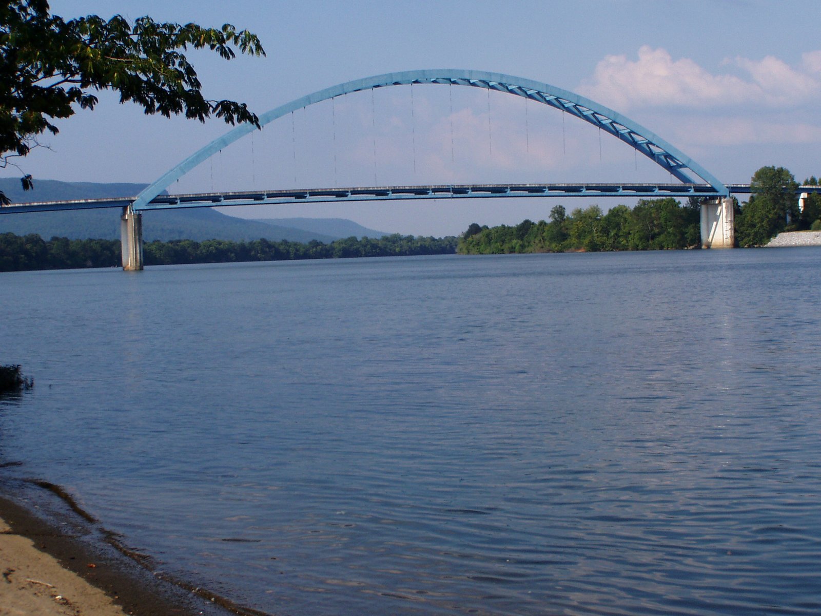
The Shelby Rhinehart Bridge, locally known as the Blue Bridge for its distinctive blue steel arches, carries Tennessee State Route 156 over the Tennessee River at South Pittsburg. The bridge connects South Pittsburg to New Hope on the south bank and is one of the most recognizable landmarks in the county. The bridge opened in 1981 as a steel tied-arch structure 1,514 feet long, replacing a ferry crossing that had operated for more than 75 years. See the Blue Bridge subpage for detailed construction, design, and naming history.
Interstate 24
Interstate 24, completed through Marion County in the 1960s and 1970s, reshaped the county's economy and settlement patterns more than any infrastructure project since the railroad arrived. I-24 tied the Sequatchie Valley directly into the Chattanooga-Nashville freight corridor, opened the county to daily commuters into Chattanooga, and concentrated retail, services, and hospitality at the Kimball interchange (exit 152). The Monteagle Mountain grade on I-24 is a well-known stretch for truckers and remains one of the more challenging interstate climbs in the Southeast.
Marion County Airport
Marion County Airport, known formally as Marion County–Brown Field (IATA APT), is a publicly owned general-aviation airport serving the county seat. The single asphalt runway (4/22, 3,500 × 75 feet) handles small general-aviation traffic, personal aircraft, occasional corporate flights, and emergency medical helicopter service. There is no scheduled commercial airline service in Marion County; the nearest commercial passenger airport is Chattanooga Metropolitan (CHA), about 35 miles east along I-24. Hang gliding at the Tennessee Tree Toppers' Henson Gap and Whitwell launch sites is the most visible aviation activity in and around the county even though it takes place outside the formal airport operation. See the Marion County Airport subpage for detail.
Present-day freight movements
Day-to-day freight in Marion County runs on three modes. Barge traffic on the Tennessee River through Nickajack Lock moves bulk commodities, principally coal, aggregates, chemicals, and grain, between upper Tennessee Valley shippers and Ohio and Mississippi river connections. CSX freight rail on the former NC&StL corridor handles the timber, aggregates, and chemical traffic that remains on the Jasper and Sequatchie Valley lines after the decline of coal and iron shipping. The I-24 interstate handles most of the county's consumer-goods and manufacturing freight, with the Kimball interchange acting as the local distribution node.
Lodge Cast Iron, the county's largest private industrial operation, depends on a two-site operation connected by the Blue Bridge: the foundry in South Pittsburg on the north bank and the 212,000-square-foot distribution center in New Hope on the south bank. Every finished skillet and Dutch oven that leaves Lodge crosses the Blue Bridge on a truck. Koch Foods' poultry-complex feed trucks moving through the county to contract growers and live-haul trailers moving broilers to the Chattanooga processing plant are the other high-volume local freight movement (see the poultry subpage).
Public transit and buses
Marion County has no fixed-route public bus system. Regional demand-response service for older adults, people with disabilities, and general public trips is provided by the Southeast Tennessee Human Resource Agency (SETHRA) under TDOT-funded coordinated transit contracts, with additional private intercity bus service via connections at Chattanooga. Most day-to-day travel in the county is by personal vehicle, which is reflected in the county's ACS 2020–2024 commuting-mode figures showing over 90 percent drive-alone or carpool trips to work.
Why it all matters
Marion County's transportation infrastructure has shaped almost everything else about the county. River navigation made the Lower Towns and, later, the 19th-century industrial economy possible; the NC&StL tied mines and foundries into national markets; US 41 and I-24 turned the Kimball interchange into a modern commercial hub. Where the routes go, and where they used to go, still defines where people live and work.
Related
About the NC&StL Railway →
All Marion County railroads (corridor inventory) →
About Interstate 24 →
About U.S. 41 & the Dixie Highway →
About the Shelby Rhinehart “Blue” Bridge →
About Marion County Airport →
About Hales Bar Dam →
About Nickajack Lake, Cave, and Dam →
About Haletown and Guild →
About Kelly's Ferry →
About Shellmound →
Sources
- Wikipedia — Nashville, Chattanooga and St. Louis Railway
- Wikipedia — Interstate 24 in Tennessee
- Wikipedia — Hales Bar Dam
- Wikipedia — Nickajack Dam
- Wikipedia — Tennessee River
- Wikipedia — Marion County Airport, Tennessee
- Wikipedia — US Route 41 in Tennessee
- Wikipedia — US Route 72
- Southeast Tennessee Human Resource Agency (SETHRA)
- Tennessee Encyclopedia — Marion County
- Wikipedia — Shelby Rhinehart Bridge
- Historic South Pittsburg Preservation Society — Sequatchie Valley Railroad