Last updated: April 23, 2026
- Route: Interstate 24 (Illinois to Chattanooga, TN); 180 miles through Tennessee
- Marion County segment: Sequatchie Valley crossing, Monteagle Mountain grade, Kimball interchange, Jasper, Nickajack Lake bridge
- Key Marion County openings: Monteagle western ascent, February 6, 1962; Marion County to Monteagle, late 1966; Nickajack Lake bridge (SR 27 to SR 156), December 18, 1967
- Nashville-Chattanooga completion: December 16, 1971
- Monteagle grade: 4 to 6 percent over 12 to 13 miles; elevation exceeding 2,000 feet at summit
Interstate 24 crosses Marion County on its run from Nashville to Chattanooga. Its construction through the county in the 1960s reshaped the local economy: it made the Sequatchie Valley a day-commute and day-visit destination from Chattanooga, concentrated retail and service businesses at the Kimball interchange, and turned the long-standing mountain crossing at Monteagle Mountain into a piece of federal infrastructure rather than a local road. The full Nashville-to-Chattanooga corridor was not complete until December 16, 1971, making I-24 the last mainline interstate highway in Tennessee to be finished.
Construction timeline
I-24 was built across Monteagle Mountain in stages between 1958 and 1971. The first major section, the western ascent from US 64 near Pelham to US 41 at Monteagle, was started in September 1958 and opened to traffic on February 6, 1962. This segment eliminated a stretch of US 41 with several hazardous hairpin curves. The Marion County sections from the valley floor to Monteagle Mountain were complete by late 1966. A short segment between SR 27 and SR 156 in Marion County, including the bridge over Nickajack Lake, opened on December 18, 1967. The last gap in the Nashville-to-Chattanooga corridor (SR 64 to US 41) closed on December 16, 1971, making I-24 the last mainline interstate highway in Tennessee to reach full completion.
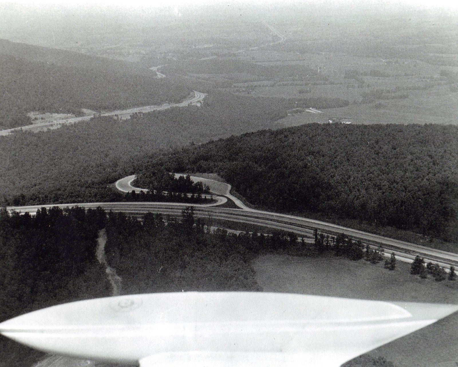
Engineering constraints on the Monteagle crossing were unusual. The eastern descent drops almost 1,500 feet of elevation over roughly four miles, with curves tight enough that TDOT's designers accepted left-side runaway truck ramps on the downgrade, an unusual configuration dictated by terrain. The single biggest departure from standard interstate design was the median: at its widest, the one-mile gap between the eastbound and westbound lanes at the summit is among the widest interstate medians in the United States, a consequence of the separate alignments the engineers needed to find down each face of the mountain.
Monteagle Mountain grade
The most famous stretch of I-24 in Marion County is the Monteagle Mountain grade, where the highway rises from the Sequatchie Valley floor to the top of the Cumberland Plateau. The crossing spans 12 to 13 miles across Marion and Grundy counties, with grades of 4 to 6 percent and a summit elevation exceeding 2,000 feet. The eastern descent features a 6 percent grade over 4.1 miles; the western descent drops at 5 percent over 4 miles.
Heavy truck traffic on the Nashville-Chattanooga freight corridor, combined with frequent fog, ice, and steep grades, has made Monteagle one of the more hazardous stretches of interstate highway in the eastern United States. Two runaway truck ramps are positioned on the left side of the eastern downgrade (an unusual arrangement dictated by terrain), and speed limits are reduced to 55 mph for general traffic and 45 mph for trucks on both descents. A truck inspection station sits at the top of the eastern grade.
Between 1985 and 1989, a $29.5 million reconstruction project extensively straightened and rebuilt the eastbound lanes on the eastern downgrade, added left shoulders, an additional runaway truck ramp, and a truck brake-adjustment station (opened January 1992). The project reduced eastbound accidents from 54 in 1983 to three in 1991. Subsequent maintenance and resurfacing projects have continued at roughly ten-year intervals. The Monteagle grade remains in the TDOT long-range pavement program as one of the more capital-intensive segments of interstate in the state.
Closures at Monteagle are a recurring feature of the regional weather record. The grade has been closed for extended periods during the January 1951 ice storm (which predated I-24 but affected U.S. 41 on essentially the same alignment), the March 12 to 14, 1993 Superstorm, the January 2002 ice event, and the February 2026 ice storm that drew ice-storm warnings for Monteagle and Marion County. A single multi-day Monteagle closure reroutes Chattanooga-Nashville freight through the Birmingham or Knoxville corridors and strands travelers at Monteagle lodging, a pattern that has repeated several times since I-24 opened.
Truck crashes on the Monteagle grade have also been a persistent safety story. The runaway truck ramps on both faces have been used repeatedly since the 1980s, and a fatal crash in December 2021 on the eastern descent drew a new round of TDOT scrutiny of the eastbound downgrade. Chattanooga television and the Chattanooga Times Free Press cover Monteagle truck incidents in enough volume to track a partial annual chronology.
Kimball interchange
The I-24 / U.S. 72 interchange at Kimball (Exit 152) became the county's commercial center after the interstate opened. Retail strips, fuel stops, restaurants, and lodging clustered along the interchange and displaced downtown Jasper and South Pittsburg as the default commerce node for the county. Kimball's growth through the late 20th century tracks almost exactly with I-24 traffic volumes. The town was formally incorporated in 1968, essentially as an interchange jurisdiction, and has expanded its commercial footprint continuously since then. Read more about Kimball →
At Monteagle (Exit 134), a parallel cluster of hotels, gas stations, and restaurants grew up on the west side of the mountain, anchored for decades by Jim Oliver's Smoke House Restaurant until the April 2021 fire destroyed the main building. The Monteagle interchange straddles the Marion-Grundy county line and contributes to both counties' tourism and commercial base.
Economic impact
Beyond the interchange-area retail, the interstate opened Marion County to distribution-oriented employers, tourism traffic, and Chattanooga-area commuters. Lodge Cast Iron's 2017 decision to build a 212,000-square-foot distribution center in New Hope relied on I-24 access at Kimball for outbound truck freight to national retailers. Koch Foods' poultry-complex feed trucks and broiler haulers running between the Chattanooga plant and contract growers in Marion County use the I-24 corridor on every run. The interstate has also facilitated the rise of Jasper Highlands and other mountain-top residential developments whose buyers commute to Chattanooga for work.
The interstate contributed to the decline of downtown-centered commerce in the older industrial-era towns. Jasper's courthouse square, South Pittsburg's Cedar Avenue, and Whitwell's downtown all lost commercial tenants through the 1970s and 1980s to the Kimball interchange cluster. Some downtown vacancy recovery has come through the Tennessee Main Street program (Jasper was designated in March 2014) and through festival-driven reuse in South Pittsburg, but the interchange-vs-downtown balance of the Marion County retail economy has tipped decisively toward the interstate.
Tourism to Foster Falls, the Tennessee River Gorge, Nickajack Lake, and Sweetens Cove Golf Club all benefits from I-24 access; the corridor has also enabled the weekend-visitor market for Monteagle Assembly and the South Pittsburg National Cornbread Festival. See the tourism and recreation subpage for the broader post-interstate tourism economy.
Related
About Marion County transportation history →
About U.S. 41 & the Dixie Highway →
About the Shelby Rhinehart “Blue” Bridge →
About tourism & recreation →
About Kimball →
About Monteagle →
About Jasper →