Last updated: April 23, 2026
- TVA created: May 18, 1933 by the Tennessee Valley Authority Act
- Hales Bar Dam transferred to TVA: 1939 (TEPCO acquisition); retired December 14, 1967
- Nickajack Dam construction: 1964 to 1967
- Nickajack Dam completed: December 14, 1967
- Nickajack Lake: about 10,370 surface acres; 46-mile pool from the dam upstream to Chickamauga Dam
- Nickajack Cave gated: 1981, to protect an endangered gray bat colony
- Interstate 24: built through Marion County 1958 to 1972, paralleling much of the TVA-era infrastructure push
The Tennessee Valley Authority, created by act of Congress on May 18, 1933, reshaped Marion County more thoroughly than any intervention since the 1794 Nickajack Expedition. TVA tamed the Tennessee River, flooded a significant amount of the county's bottomland, generated hydroelectric power that brought grid electricity to isolated plateau households, and funded dam and road construction projects that employed thousands of Marion County men through the worst years of the Great Depression and into the post-war decades. The agency replaced Marion County's most famous dam (Hales Bar) with Nickajack Dam in 1967, displacing families at Mullins Cove and Shellmound, partially flooding the site of Nickajack town and Nickajack Cave, and creating the reservoir that anchors most modern recreation along the Marion County stretch of the river. This page traces the TVA era in the county, from the 1933 creation of the Authority through the closeout of active dam construction in the early 1970s.
The 1933 TVA Act and Marion County's starting conditions
When the TVA Act was signed by President Franklin D. Roosevelt on May 18, 1933, Marion County was in the fifth year of the Great Depression. The industrial boom of the 1880s and 1890s had already faded. Coke ovens were cold, coal mines operated at reduced output, and the county's iron and steel operations at South Pittsburg and Richard City had downsized or closed. Rural electrification was limited: the Hales Bar Dam, built in 1913 by the Chattanooga and Tennessee River Power Company and operated by the Tennessee Electric Power Company (TEPCO), supplied power mostly to Chattanooga industrial customers. Farms along the Sequatchie Valley and on the plateau mostly lacked electric service. Kerosene lamps, wood stoves, and hand-pumped water were the rural norm.
TVA's founding mission combined flood control, navigation, power generation, and economic development. The region-wide strategy included acquiring private utility assets, building new dams, and extending rural electric lines. In Marion County, that strategy played out through a decade-long acquisition of TEPCO (completed 1939), the transfer of Hales Bar to TVA operation, and the gradual extension of rural electric cooperatives across the plateau and valley through the late 1930s and 1940s.
Rural electrification
The Sequachee Valley Electric Cooperative, incorporated July 31, 1939 under the 1936 Rural Electrification Act, extended power lines into parts of Marion County that commercial utilities had never reached. Plateau farms, tenant houses, and remote coves received grid electricity for the first time in the late 1930s and through World War II. Oral histories of the arrival of electricity in Marion County communities, collected decades later by state and regional folklife programs, describe the change as one of the largest quality-of-life improvements in a generation: refrigeration, electric lighting, and radio reached rural households that had been operating on 19th-century domestic technology within living memory.
Industrial electrification had a different texture. TEPCO-era industrial customers in the Chattanooga area, already served by Hales Bar power, continued their existing connections under TVA rates. South Pittsburg's foundries, notably Lodge Cast Iron, transitioned from private utility contracts to TVA supply by the early 1940s. The rate structure TVA offered, significantly below the TEPCO rates that had preceded it, became part of the post-war industrial-recruitment pitch that the Marion County Partnership for Economic Development and its predecessors would use for decades.
Hales Bar: a dam that never quite worked
Hales Bar Dam, built 1905 to 1913 in Hamilton County just upstream of the Marion County line, had been the first significant dam on the main stem of the Tennessee River. It leaked from the day it opened. The dam sat on karst limestone, a foundation riddled with solution channels that no amount of engineering could fully seal. Five major grouting campaigns between 1919 and 1957 each patched the worst leaks, and each time new ones opened on the next cycle. By the late 1950s, roughly 30,000 gallons of water per minute were passing through the foundation, the generating units were aging, and TVA concluded that the dam could not be saved.
TVA studied replacement options through the late 1950s and early 1960s. The preferred plan was to abandon Hales Bar entirely and build a new dam downstream at a site with sound foundation rock. The chosen site sat roughly six miles below Hales Bar, at the mouth of Nickajack Cave in the heart of Marion County. The Nickajack Dam project was authorized on January 9, 1964, and construction began that April.
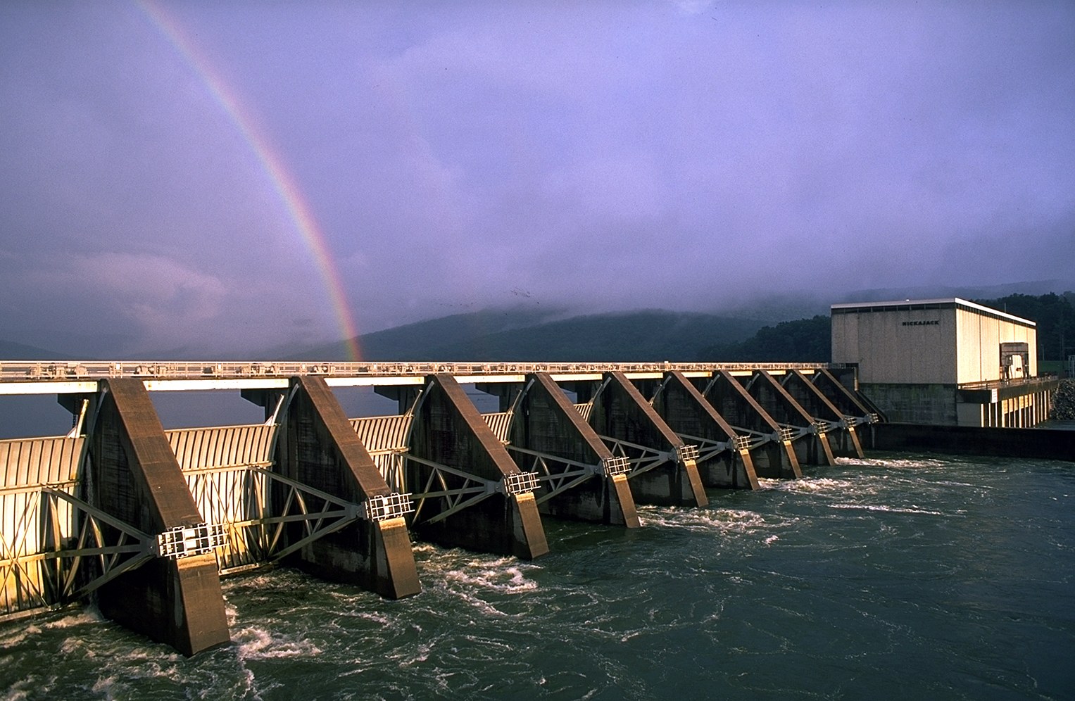
Nickajack Dam, 1964 to 1967
Nickajack Dam was built between 1964 and 1967 by a TVA-led construction effort involving multiple private contractors. At its peak, the project employed several thousand workers, many of them from Marion County. The dam was completed and impounded its pool on December 14, 1967, the same day Hales Bar Dam was formally retired and its generators shut down. Two of the Hales Bar generating units were disassembled and moved downstream for reuse; the rest of the dam was breached to allow unimpeded flow to Nickajack Lake, which now covered the former Hales Bar pool as part of its own backwater. The Hales Bar powerhouse structure was retained as a site for boat services and marine operations and still stands today.
Nickajack Dam's generating capacity was about 105 megawatts at installation (upgraded in later unit replacements). Its locks have dimensions of 110 by 600 feet (and 110 by 800 feet for the larger lock), suited to Tennessee River barge traffic. The reservoir, Nickajack Lake, had a surface area of about 10,370 acres and extended upstream roughly 46 miles to the Chickamauga Dam just above Chattanooga. The lake's footprint covered the former Hales Bar pool, the old river-level sites of Nickajack and Running Water (the 1794 Cherokee towns), and low-lying bottoms along both banks upstream. Nickajack Cave hosts a maternity colony of federally endangered gray bats (Myotis grisescens) estimated at up to 100,000 individuals during peak summer occupancy.
Displacement at Mullins Cove and Shellmound
The Nickajack Lake impoundment displaced families along the river's north and south banks. The best-documented displacement is at Mullins Cove on the north bank, where the Long family 2,000-acre tract settled by Henry and Zilpha Long between 1807 and 1811 was partially flooded, including the historic Long Cemetery #2, which is now partially submerged at the waterline. Headstones become visible at low pool. Mullins Cove families relocated to higher ground on the north bank or moved out of the cove entirely. The TVA land-acquisition records for the Nickajack Lake footprint are held in the National Archives and at the TVA Knoxville administrative archive.
At Shellmound on the south bank, the impoundment submerged the prehistoric shell midden that gave the community its name and the adjacent farm bottom where the mound had stood. The Shellmound Recreation Area, now TVA-managed, sits on the relocated alignment of TN-156 and the former site of the community. Several other smaller settlements along the banks, riverside homes at Nickajack, small clusters below Haletown, bottomland farms between Shellmound and Guild, were also displaced.
The displacement was narrower in extent than at some earlier TVA projects (the Norris Dam displacement of the mid-1930s had moved several thousand families), but the disruption to the families actually displaced was substantial. Families who had farmed the same bottomland since before the Civil War, including descendants of the first non-Cherokee settlers of the Tennessee River gorge, were relocated to higher ground with TVA purchase payments that, by the judgment of several subsequent oral-history accounts, did not fully replace the productive value of the land taken.
Nickajack Cave and the gray bats
Nickajack Cave's entrance sits just west of the Nickajack Dam, and the pool raised by the dam partially flooded the cave mouth. The historic entrance, previously walkable from the river terrace, became a water-level opening accessible only by boat. The inner galleries, which had been mined for saltpeter during the War of 1812 and the Civil War and used as a tourist curiosity in the late 19th century, remained dry above the new waterline but lost their pedestrian access from the old riverbank.
Inside the cave, a large summer colony of gray bats (Myotis grisescens), a federally endangered species, used the cave as a maternity roost. In the post-dam years, unregulated tourist visits and disturbance of the roost threatened the colony's reproductive success. In 1981, TVA installed a bat-friendly gate at the cave entrance, blocking human access while allowing bats to fly in and out. An observation platform was built on the bluff above the cave (accessible via Maple View Lane) so visitors could watch the summer-evening bat emergence from a distance that did not disturb the colony. The gate and platform are still in place. Colony counts have varied over the decades, with peaks over 100,000 bats in some years; see the caves page for the conservation detail and the open question about post-2010 white-nose syndrome effects on the colony.
Other TVA-era projects in Marion County
Beyond the Hales Bar to Nickajack transition, TVA-era infrastructure work in Marion County included:
- Rural road improvements funded in part by TVA land-acquisition payments and by parallel New Deal road programs (WPA, CCC, PWA). See the Depression and WPA subpage for the road and school projects funded by New Deal agencies during the 1930s.
- Flood easements and drainage improvements along the lower Sequatchie River and Battle Creek, part of TVA's broader tributary-stream management program.
- Tourist and recreational development at Nickajack Lake, including the Shellmound Recreation Area, the Maple View bat observation platform, and the Nickajack Dam visitors' overlook.
- Fish and wildlife management in partnership with the Tennessee Wildlife Resources Agency: walleye stocking, smallmouth bass management, gray-bat and cerulean warbler habitat work, and the Raccoon Mountain archaeological survey that has since documented Civil War and moonshine-era sites.
The economic shift
The TVA era coincided with, and helped produce, a long shift in Marion County's economic base from extractive industries (coal, iron, coke) to a mixed economy of manufacturing, services, and tourism. The low TVA power rates helped keep Lodge Cast Iron competitive against larger coastal foundries and supported new arrivals like the Dixie Portland Cement operation at Richard City. Federal highway construction, culminating in Interstate 24's completion through Marion County between the late 1960s and 1972, connected the county to the Nashville and Chattanooga markets in ways no 19th-century railroad had. The first generation of industrial-park recruitment, lake-house second-home development, and highway-corridor retail at Kimball, all of which would reshape the county through the late 20th century, had TVA-era infrastructure as a direct precondition.
The TVA era is not a clean unit. It blends at its beginning into the Depression and New Deal, and at its end into the modern era of manufacturing and tourism. Taken as a span, it is the period in which Marion County's relationship to the Tennessee River was rebuilt from a natural obstacle that 19th-century boatmen feared into a managed resource that mid-20th-century communities used for recreation, irrigation, and power.
Related
Depression and WPA era in Marion County →
Hales Bar Dam →
Nickajack Cave, Lake, and Dam →
The Tennessee River in Marion County →
Mullins Cove and the Long Cemetery displacement →
Shellmound and the lost shell midden →
Sources
- Wikipedia — Tennessee Valley Authority
- Wikipedia — Nickajack Dam
- Wikipedia — Hales Bar Dam
- Wikipedia — Nickajack Lake
- Wikipedia — Nickajack Cave
- TVA — Nickajack hydroelectric project
- TVA — Our history
- Tennessee Encyclopedia — Tennessee Valley Authority
- Tennessee Encyclopedia — Marion County
- Wikipedia — Gray bat (Myotis grisescens)
- Structurae — Nickajack Dam