Last updated: June 3, 2026
- Total length: ~652 miles (Knoxville to mouth at Paducah, Kentucky)
- Marion County reach: ~26 miles from Haletown to the Alabama line
- Current form in the county: Nickajack Lake (TVA reservoir, 1967)
- Dams on the Marion County reach: Nickajack Dam (active); Hales Bar Dam (1913–1968, removed)
- Tributaries (partial): Sequatchie River, Battle Creek, Mullins Creek, Suck Creek, Running Water Creek
- Historic rapids (submerged): The Suck, Boiling Pot, Skillet, Frying Pan, Tumbling Shoals, Deadman's Eddy
The Tennessee River forms the southern boundary of Marion County for most of its length and is the defining geographic element of the county's history. It is the reason the Cherokee Lower Towns of Nickajack and Running Water anchored here, the reason 19th-century river commerce passed through, the reason Hales Bar Dam and Nickajack Dam were built, and the reason the towns of South Pittsburg, Shellmound, Guild, and Haletown stand where they do. This page treats the river as a physical and ecological feature. Adjacent topics are separated onto their own pages: the Tennessee River Gorge handles the canyon as a landform; Nickajack Lake, Cave, and Dam handles the reservoir and associated features; the Suck Rapids page handles the vanished 19th-century rapids as a cultural memory; and the Hales Bar Dam and transportation pages cover the engineering and commercial dimensions.

The river's course through Marion County
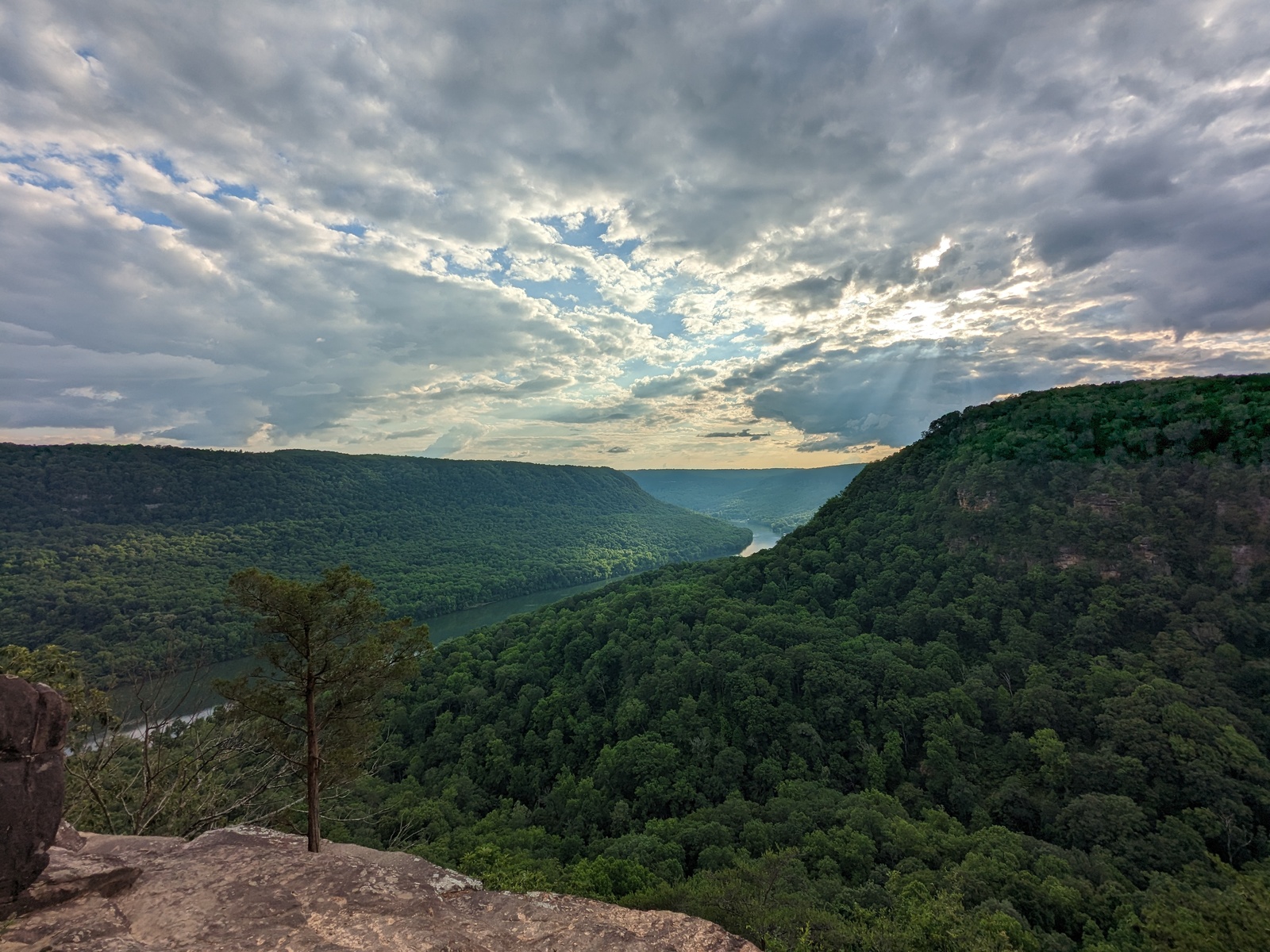
The Tennessee River enters Marion County from Hamilton County on the east, near the mouth of Suck Creek, and leaves the county on the west, crossing the Alabama state line near Shellmound and the Russell Cave vicinity. In its Marion County course it flows roughly southwest, carving through the Cumberland Plateau in the 26-mile Tennessee River Gorge that is the county's defining natural landmark. The river enters as part of Chickamauga Lake, passes through the gorge as Nickajack Lake (since 1967) or through the free-flowing gorge (before 1913), and exits toward Guntersville Lake in Alabama. Tributaries enter the gorge stretch from both sides: the Sequatchie River from the north near Kimball and Jasper, Battle Creek from the north, Mullins Creek and Suck Creek from the north off Walden Ridge, and Running Water Creek from the south through the Doran Cove area near the old Cherokee town site. The river's plunge through narrow sandstone and limestone walls in the gorge is what made it navigationally difficult before the dams, and the same structure is what made the gorge the landscape-defining feature of the county's southern edge.
The river's contrary course
Long before it reaches Marion County, the Tennessee has already behaved strangely. After gathering its headwater streams, the Powell, Clinch, Holston, Nolichucky, and French Broad, the river officially becomes the Tennessee a few miles east of Knoxville and runs southwest toward Chattanooga. There, instead of continuing south toward the Gulf of Mexico, it turns sharply west, loops around Moccasin Bend, and crashes through the Cumberland Plateau into the lower Sequatchie country. Raulston and Livingood, in Sequatchie (1974), call the move "a completely arbitrary and unnatural course," because the divide across the Chattanooga Valley just south of the city is so low that the river could easily have flowed through it to the Gulf. Having broken through the plateau, the river crosses the foot of the Sequatchie anticline, turns southwest again toward Guntersville, Alabama, makes a further contrary bend across northern Alabama through the reefs and bars of Muscle Shoals, and at last pivots north to join the Ohio River in Kentucky.
Geologists have long argued over how the river came to take so improbable a path. One view holds that the Tennessee once flowed south to the Gulf and was later "captured," its waters diverted by a west-flowing stream that cut headward into the divide until it pirated the upper river and drew it through the plateau, abandoning the old southward channel. Another holds that the river never flowed south at all, but followed roughly its present course from the beginning, deepening its canyon as the surrounding mountains slowly rose around it. The question of stream "piracy" versus an ancestral course through the plateau is still unsettled, but either way the result is the same: the deep gorge that defines Marion County's southern edge. For the canyon itself, see the Tennessee River Gorge page.
Pre-dam river: free-flowing Tennessee
Before Hales Bar Dam went into operation in 1913, the Tennessee River through Marion County was free-flowing, shallow in dry seasons, cataract-ridden where it crossed resistant bedrock, and notorious among steamboat pilots for the worst navigable stretch on the inland U.S. river system. A continuous sequence of rapids, The Suck (near the mouth of Suck Creek), The Boiling Pot (where the gorge narrows severely), The Skillet, The Frying Pan, Tumbling Shoals, Deadman's Eddy, and Holston Rock, funneled water dangerously through narrow channels, snags, and whirlpools. Flatboats, keelboats, and later steamboats frequently wrecked or ran aground here; the Suck in particular became the most cited hazard of Tennessee River travel. The rapids also shaped 19th-century commerce: cargo was often portaged around the worst sections, and the Jasper Branch Railroad, opened from Bridgeport to Jasper in 1867, eventually displaced much of the through-river freight with rail. The rapids are now entirely submerged beneath Nickajack Lake; sediment and reservoir water have filled the channels once feared. For detailed treatment see the Suck Rapids page.
Hales Bar Dam and Nickajack Dam
Hales Bar Dam, completed in 1913 between Guild and the river's south bank in Marion County, was the first major dam on the Tennessee River. It was built by the Tennessee Electric Power Company and was, at the time, the largest hydroelectric project in the world. Hales Bar was also an immediate engineering problem: it sat on karst limestone that leaked continually, and attempts to grout the foundation through decades of operation never fully succeeded. TVA acquired the dam in 1939 and by 1960 the dam was losing roughly 2,000 cubic feet per second through its base. The decision to replace Hales Bar rather than repair it led to construction of Nickajack Dam, about six miles downstream on more solid bedrock, completed on December 14, 1967. Hales Bar's powerhouse was demolished in 1968; sections of its lock structure remain as a marina. For full engineering and worker-village detail see Hales Bar and Nickajack.
Nickajack Lake: the Marion County reach today
Since 1967, the entire Marion County reach of the Tennessee River has existed as Nickajack Lake, a TVA reservoir approximately 46 river miles long stretching upstream from the dam to Chickamauga Dam. Its normal pool elevation is 633.5 feet; unlike Chickamauga Lake upstream, Nickajack's pool does not fluctuate seasonally. Lake surface area is about 10,370 acres at full pool. Primary uses are hydroelectric power (104 MW), navigation (a 600-by-110-foot lock moves barge traffic), flood control, and recreation. The lake averages about 45 feet deep through the middle of the Marion County stretch and reaches 145 feet at its deepest point in the old channel immediately above the dam.
The conversion of the gorge reach from rapids to a constant-pool reservoir reshaped the county's river frontage. Communities that had been set back from the old dangerous channel, Haletown, Guild, Shellmound, South Pittsburg, lost historic access to working river bottoms but gained consistent navigable water and the economic predictability a reservoir brings. Old Cherokee town sites, including parts of Nickajack and Running Water, were inundated; a number of historic cemeteries along the gorge were either relocated above pool or submerged; and the narrow navigational channel through the Suck became an unremarkable flat pool. Nickajack Lake is now a destination for recreational boating, bass fishing (the world record for freshwater drum, 54 pounds 8 ounces, was caught here in 1972), and summer-evening kayak viewing of Nickajack Cave's gray-bat emergence.
Tributaries
The largest Marion County tributary of the Tennessee is the Sequatchie River, a 116-mile waterway that drains the Sequatchie Valley from near Crossville south to Kimball, where it joins the Tennessee on the east side of town. The Sequatchie is the only major tributary of the Tennessee that rises and drains entirely in Tennessee and has no TVA dam on it; it remains free-flowing. For full treatment see the Sequatchie River page. Other significant Marion County tributaries of the Tennessee include:
Battle Creek, entering from the north through the cove that gave the 1854 mining community its name. The creek drains a large plateau embayment above the gorge. Suck Creek, entering from the north bank at the far eastern end of the gorge; it gave its name to the old rapids at its mouth. Mullins Creek and associated smaller streams entering from Mullins Cove on the north bank. Running Water Creek, entering from the south through Doran Cove; its name marks the pre-contact Cherokee town. Little Cedar Mountain drainages, short creeks from the south bank that drain the Alabama-line ridges before joining the Tennessee. None of these tributaries has a dam within Marion County; all are free-flowing within their county reach.
Ecology
The Marion County stretch of the Tennessee River sits at a junction of three aquatic systems: the free-flowing Sequatchie River draining from the north, the reservoir-reach main stem of the Tennessee, and the karst spring and tributary networks that enter from the gorge walls. The reservoir and tailwater together support roughly 91 documented or expected fish species, one of the highest counts in any temperate river system, including sport fisheries for largemouth, smallmouth, white, and striped bass, channel and trophy-sized blue catfish, walleye and sauger in the cool tailwater below Nickajack Dam, and both crappie species in the impoundment's coves. In 2011, a lake sturgeon was caught in Nickajack Lake, the first regional sighting of the species since it disappeared locally in the 1960s; subsequent surveys suggest a slowly recovering population supported by the Tennessee Aquarium / TWRA reintroduction project upstream. The Tennessee River drainage is also the world center of darter diversity, with thirteen species documented or expected in the Marion reach. The snail darter, federally listed in 1975 and delisted in 2022 after recovery, is documented in multiple Tennessee River drainage tributaries. The gray-bat colony at Nickajack Cave forages extensively over the lake's surface on summer nights, feeding on mosquitoes, midges, and moths; an estimated 100,000-plus bats can consume tens of tons of insects over the Marion County reach each summer. Freshwater mussel populations in the Marion County reach declined sharply after Nickajack Dam's construction and the loss of the free-flowing rapids but persist in tributaries and along reservoir shoals. For details on aquatic species see the fish and aquatic life section of the fauna page and the endemic species page.
Human history on the river
Indigenous use of the Tennessee River through Marion County dates to Paleo-Indian times, with continuous archaeological evidence of occupation along the gorge for at least 10,000 years. Mississippian mound sites are known along the Marion County bank; the valley's deep prehistory, and the excavations at Russell Cave and Nickajack that recorded it, are traced on the In the Beginning page. In the late 18th century, the Chickamauga Cherokee under Dragging Canoe founded the Lower Towns of Nickajack, Running Water, and their satellites in the gorge as defensive bases during resistance to Anglo-American expansion; the towns were destroyed by the Ore Expedition in 1794. The 19th century brought flatboat, keelboat, and steamboat commerce, with The Suck as the defining hazard. Civil War operations in the Chattanooga Campaign of 1863 ran the length of the Marion County river bank: Union supply lines used Kelly's Ferry as the western end of the "Cracker Line" that relieved besieged Chattanooga, and the Confederate Nitre Bureau mined Nickajack Cave for saltpeter. Twentieth-century industrialization brought Hales Bar Dam, Dixie Portland Cement and other river-dependent industries, the Guild and Ladds worker villages, and finally the TVA-era Nickajack Dam. The river remains the principal corridor along which the county's deep history is arranged.
Flooding
The Tennessee River through Marion County produced some of the most destructive flood events in Tennessee history before the TVA system. The 1867 flood is the largest on record, cresting at about 58 feet at Chattanooga; the 1875, 1886, and 1917 floods also overran Marion County bottomlands. Since Hales Bar and especially since the completion of the full TVA system, catastrophic main-stem flooding has been largely prevented. The worst post-TVA event was the 1973 flood, which crested at nearly 37 feet at Chattanooga; TVA modeling estimates the same event would have crested at 52 feet without regulation, comparable to the 19th-century floods. For the full flood record see the weather and climate page.
Related
About the Tennessee River Gorge →
About Nickajack Lake, Cave, and Dam →
About The Suck rapids →
About Hales Bar Dam →
About the Sequatchie River →
About Marion County weather and floods →
Sources
- Wikipedia — Tennessee River
- Wikipedia — Nickajack Lake
- Wikipedia — Nickajack Dam
- Wikipedia — Hales Bar Dam
- TVA — Nickajack Dam
- TVA — Floods of the Past
- USGS SIR 2017-5052 — Prehistoric floods on the Tennessee River
- TVA — Environmental stewardship reports
- Tennessee Aquarium Conservation Institute — Lake Sturgeon Reintroduction Project
- J. Leonard Raulston and James Weston Livingood, Sequatchie: A Story of the Southern Cumberlands (Knoxville: University of Tennessee Press, 1974), chapter 2, "Visitors and the Land," pp. 20–21 (the river's contrary course and the stream-capture debate).