Last updated: June 3, 2026
- Length: ~26 miles (42 km)
- Rank: Fourth-largest river gorge in the eastern United States
- Counties: Marion and Hamilton, Tennessee (and adjacent Alabama)
- Nickname: "The Grand Canyon of Tennessee"
- Management: Tennessee River Gorge Trust, TVA, Prentice Cooper State Forest
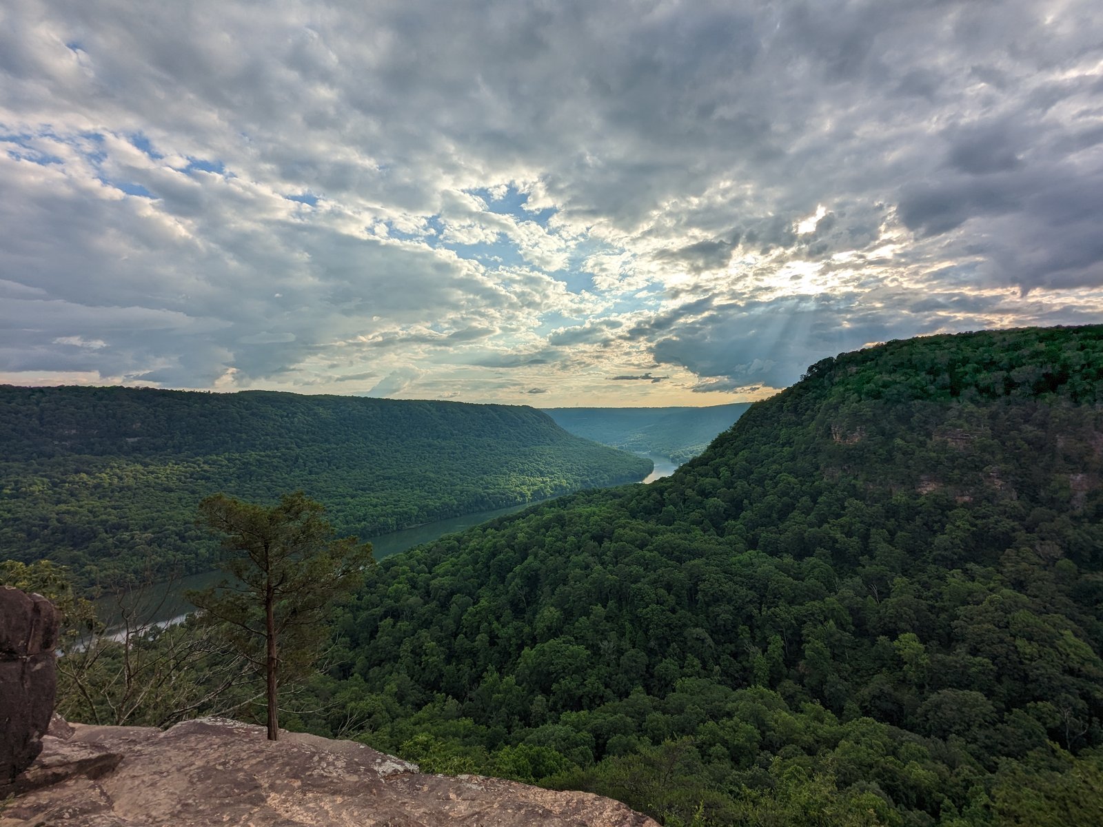
The Tennessee River Gorge is a 26-mile canyon carved by the Tennessee River where it cuts through the Cumberland Plateau between Chattanooga and the Alabama state line. The Marion County portion runs from around Haletown and Guild to the Alabama border. Sometimes called the "Grand Canyon of Tennessee," the gorge is the fourth-largest river canyon east of the Mississippi. Its older name was Walden Gorge, and it has been locally called Cash Canyon as well; the early rivermen knew its core, the roughly twenty-mile run between Raccoon Mountain and the southern end of Walden Ridge, as the Narrows, or the Canyon of the Tennessee. Archaeological evidence shows human habitation in the gorge for at least 10,000 years.
Geology
The gorge was carved by the Tennessee River cutting through Walden Ridge, the eastern escarpment of the Cumberland Plateau. The canyon walls expose a cross-section of the plateau's rock layers: Pennsylvanian-age sandstones and conglomerates cap the ridgelines, with progressively older Mississippian limestones and shales exposed lower on the slopes. The slopes rise up to roughly 1,800 feet above the river, creating a narrow, winding channel through hard sandstone and limestone ledges. The gorge divides Walden Ridge on the north from Sand Mountain to the south, with the river threading between them in a series of tight bends.
Ecology and rare species
The gorge supports an unusual concentration of plant and animal diversity. Its steep limestone cliffs, hardwood slopes, cove forests, and side hollows create a range of microclimates and habitats within a relatively small area.
The most significant rare plant in the gorge is the large-flowered skullcap (Scutellaria montana), a federally threatened species endemic to Tennessee and Georgia. More than half of all known plants of this species, and most of its largest populations, grow on land owned by the Tennessee River Gorge Trust. In Marion County, populations range from about 50 plants to more than 40,000 plants. The species grows on dry to slightly moist rocky slopes within undisturbed, mature oak and hickory woodlands with trees 70 to over 200 years old. It was originally listed as endangered and later downlisted to threatened in 2002 as conservation efforts, primarily land protection by the Trust, stabilized its habitat.
Woodland bogs in the gorge provide habitat for rare plants, amphibians, and other wildlife that depend on standing water. The Trust conducts ongoing bird-banding studies for cerulean warbler and worm-eating warbler on its properties, and has undertaken canebrake restoration along the river to stabilize banks, improve water quality, and rebuild habitat. Each fall, river-following kettles of hundreds of broad-winged hawks migrate down the gorge in mid-September; the comprehensive Marion County 206-species bird inventory covers the gorge's year-round, breeding-migrant, and wintering communities.
Historic rapids
Before river modification, the gorge contained a series of rapids notorious as the most dangerous passage on the inland river system in the 19th century. They were known by vivid names: The Suck, The Boiling Pot, The Skillet, The Frying Pan, Tumbling Shoals, Holston Rock, The Kettle, and Deadman's Eddy. These rapids destroyed many flatboats and steamboats and were a defining hazard of Tennessee River navigation. They were largely submerged when Hales Bar Dam raised the river level in 1913 and are now entirely beneath the surface of Nickajack Lake. Read more about The Suck →
Human history
The gorge has been a transportation corridor throughout recorded history. Cherokee used it for travel and refuge. In the late 18th century, the Cherokee Lower Towns of Nickajack and Running Water stood within the Marion County portion of the gorge, serving as bases for the Chickamauga Cherokee during their resistance to American expansion. These towns were destroyed by militia forces in the Nickajack Expedition of 1794. Read more about Nickajack & Running Water →
During the Civil War, the gorge carried both Union and Confederate troop movements. Its narrow passage made control of the river strategically important for supply lines to Chattanooga. In the 20th century, the gorge was transformed by TVA's hydro projects: Hales Bar Dam (1913), later replaced by Nickajack Dam (1967), and the Raccoon Mountain Pumped-Storage Plant, a TVA facility that uses an underground powerhouse inside Raccoon Mountain to generate electricity during peak demand.
Conservation: the Tennessee River Gorge Trust
The Tennessee River Gorge Trust (TRGT) was founded in 1981 as a nonprofit land trust dedicated to protecting the gorge's natural and scenic resources. As of 2018, the Trust has secured ownership or conservation protection for more than 17,000 of the 27,000 acres in its target area, through direct purchases, donations, and conservation easements with private landowners. The Trust builds trails, conducts environmental studies, and runs educational programs from its headquarters in North Chattanooga.
Prentice Cooper State Forest, which borders the northern edge of the gorge, covers 24,686 acres in Marion County with 35 miles of hiking trails. It is managed by the Tennessee Division of Forestry and provides public access for hiking, hunting, birding, rock climbing, and mountain biking. The forest also contains the southern end of the Cumberland Trail.
Present-day recreation
The gorge is accessible for hiking, paddling, rock climbing, and wildlife viewing. The TRGT's Ritchie Hollow Trail, a 2.5-mile trail, provides foot access into the gorge. Kayakers and canoeists paddle sections of the river through the gorge, and the area draws birders for its warbler populations. Signal Point, a National Park Service site on the Hamilton County side, offers overlooks into the gorge.
Related
About Nickajack Lake, Cave, and Dam →
About the Sequatchie Valley →
About Hales Bar Dam →
About Nickajack & Running Water →
About Whiteside, on the old Running Water trestle →
About Mullins Cove, on the north bank →
About Ladd, the south-bank Hales Bar worker village →
About Aetna, on the plateau above the gorge →
About Marion County flora →
About Marion County fauna →
About endemic and notable species →
Sources
- Wikipedia: Tennessee River Gorge
- Wikipedia: Tennessee River Gorge Trust
- Tennessee River Gorge Trust
- Prentice Cooper State Forest, Tennessee Division of Forestry
- Federal Register: Reclassification of Scutellaria montana from Endangered to Threatened (2002)
- UTC thesis: Conservation of the Federally Threatened Scutellaria montana
- J. Leonard Raulston and James Weston Livingood, Sequatchie: A Story of the Southern Cumberlands (Knoxville: University of Tennessee Press, 1974), p. 21 (the early rivermen's name for the canyon, the Narrows).