Last updated: April 27, 2026
- Major trail systems: Cumberland Trail State Park, South Cumberland State Park (Foster Falls / Fiery Gizzard / Denny Cove), Prentice Cooper State Forest and WMA, Mountain Goat Trail
- Trails inside the county: roughly two dozen named trails across the plateau rim, the Tennessee River Gorge north bank, and the Sequatchie Valley floor
- Elevation range: approximately 630 feet at the Tennessee River to over 1,800 feet on Walden Ridge and the Cumberland Plateau
- Managing agencies: Tennessee State Parks, Tennessee Division of Forestry, TWRA, TVA, the National Park Service (Signal Point), and several nonprofit partners
- Best seasons: waterfalls run heaviest from late autumn through early spring; plateau-rim hikes are most pleasant in fall and spring; summer use concentrates at Foster Falls swimming pool
Marion County's hiking is shaped by the same three-scale geography that shapes everything else here: the Sequatchie Valley floor at one end of the elevation range, the Cumberland Plateau rim at the other, and the Tennessee River Gorge cutting across the south edge of the county. The trails cluster where the landscape concentrates itself: along the plateau escarpment where streams drop as waterfalls, along the gorge's north rim where sandstone overlooks open onto the river below, and at the rare valley-floor lake-edge tracts that TVA and the county keep open as parks. This page is the hub for hikers planning a Marion County trip; the trail-system sections below link out to dedicated pages on the major destinations, and the directory and planning notes pull together the practical information visitors need in one place.
The major trail systems
Four trail networks anchor hiking in and around the county. Each has its own dedicated page on this site; the summaries here are entry points, not substitutes.
Cumberland Trail State Park
The Justin P. Wilson Cumberland Trail State Scenic Trail is the only long-distance hiking trail that officially crosses Marion County. Planned at over 300 miles from Cumberland Gap National Historical Park to Signal Point near Chattanooga, the trail had roughly 210 miles open as of 2016, with construction continuing across the Suck Creek and Mullins Cove segments along Marion County's gorge rim. The trail's southernmost built miles cross or border the county through Prentice Cooper State Forest. Most Marion County hikers know the system through three loops or sections: the Signal-to-Edwards-Points day hike out of Hamilton County, the Mullens Cove Loop from inside Prentice Cooper, and the Suck Creek bottomlands segment when river levels permit. The trail is volunteer-built; over 235,000 hours of donated labor have gone into the corridor.
South Cumberland State Park: Foster Falls, Fiery Gizzard, and Denny Cove
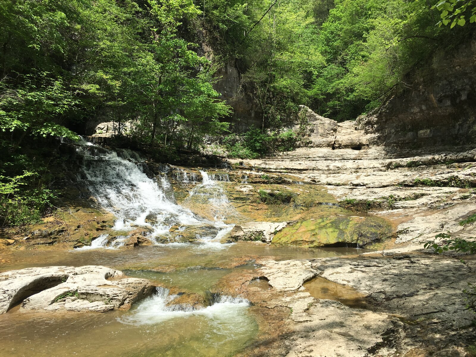
Foster Falls and Denny Cove sit at the Marion / Grundy county line on the Cumberland Plateau escarpment. Foster Falls is a 60-foot waterfall on Little Gizzard Creek, the tallest in the state-park system's southern Cumberland tract, with a 178-acre Small Wild Area, sport-climbing routes, and the southern terminus of the 12.5-mile Fiery Gizzard Trail running north to Tracy City. Backpacker magazine has cited the Fiery Gizzard among the top 25 hiking trails in the United States. Denny Cove, the 685-acre tract acquired in 2016 by the Southeastern Climbers Coalition and the Access Fund and added to the state park in 2017, sits a short distance north with three miles of cliff line, around 150 climbing routes, and a 2.7-mile round-trip trail to 70-foot Denny Falls. The South Cumberland system as a whole spans roughly 30,000 acres across nine separate tracts.
Prentice Cooper State Forest and Wildlife Management Area
Prentice Cooper is the largest contiguous public land in the Marion County area, roughly 24,686 acres of plateau forest along the north rim of the Tennessee River Gorge. The forest straddles the Marion / Hamilton line on Walden Ridge and is jointly managed by the Tennessee Division of Forestry and TWRA. Roughly 35 miles of hiking trail (in addition to the Cumberland Trail mileage that crosses the property) wind through cove-hardwood drainages and along the gorge rim. The forest's standout day-hike destinations are Snooper's Rock, Edwards Point, Indian Rockhouse, the Rainbow Lake area, and Ritchie Hollow's Blowing Wind Falls. Hunting seasons close interior forest roads to vehicles in November and December; foot traffic with blaze orange is permitted, and a free TWRA permit covers backcountry camping at the three designated camp areas.
Mountain Goat Trail
The Mountain Goat Trail is a paved rail-to-trail along the historic Mountain Goat Railroad grade, running roughly 12 miles of completed segments between Sewanee and Tracy City as of 2026. Most of the trail lies in Franklin and Grundy counties, but the Monteagle segment crosses into Marion County at the town's southern edge, and the trail is the closest paved walking and cycling path for Marion residents on the Pelham, Jasper, and Kimball side of Monteagle Mountain. The Mountain Goat Trail Alliance has begun construction on Sewanee-to-Cowan and Tracy-City-to-Coalmont extensions; the projected full corridor is approximately 40 miles.
Trails inside Marion County
Beyond the long-distance and state-park trail systems, several individual trails sit inside the county boundary. These are the destinations a hiker can claim as Marion County in the strictest sense: the trailhead, the tread, and most of the experience are inside the county line.
Marion County Park (Jasper)
Marion County Park at 9696 U.S. Highway 41 in Jasper is a county-run recreation area on Nickajack Reservoir with a paved walking loop around the ballfields and additional unpaved paths along the lakeshore. The park is the closest paved walking-and-running route for residents of Jasper, Kimball, and South Pittsburg, and it also offers camping, picnicking, fishing, a boat launch, restrooms, and showers. The terrain is flat. Pets are permitted. The paved loop is short, well under a mile, but the broader park footprint allows longer combinations on park roads and lakeside paths. The park is operated by the Marion County Parks and Recreation Department.
Little Cedar Mountain Small Wild Area
Little Cedar Mountain sits along the western shore of Nickajack Lake where Walden Ridge breaks down into the Tennessee River Gorge and blends into the Sequatchie Valley. The Small Wild Area is owned and maintained by TVA as part of the agency's recreation-land program; the trail system is open year-round, free, and managed on a leave-no-trace standard. The principal route, the Little Cedar Mountain Trail, is a 3.3-mile loop with about 400 feet of elevation gain that climbs the ridge above the lake, traverses both a drier south-facing side and a moister north-facing side, and returns via a parallel grade with periodic lake views. A longer 4.3-mile out-and-back to a small interior pond uses some of the same tread. The trailhead is reached from the TVA-marked pull-off on U.S. 41 between Jasper and Kimball; signage is modest, parking is small, and the trail is moderately popular but rarely crowded.
Cumberland Trail: Mullens Cove Loop
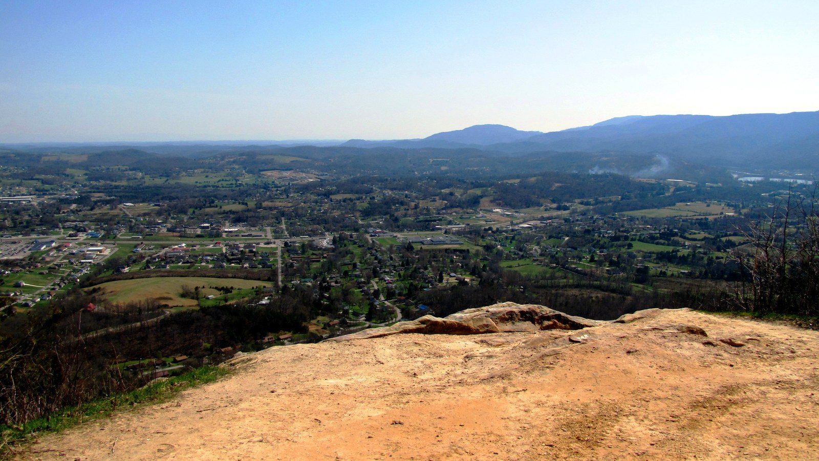
The Mullens Cove Loop, a 9.5-mile loop at the western end of Prentice Cooper, is one of the Cumberland Trail's most-used Marion County miles. The loop hangs along the rim of the gorge for a long stretch, with several views down to the Tennessee River 1,000 feet below, and the showpiece overlook is at Snooper's Rock, a sandstone outcrop just before the trail turns west into the Mullens Creek drainage. Roughly 4.5 to 5 hours' walking time at typical pace; about 1,500 feet of cumulative gain across switchbacks and drainage crossings. Forest cover is mesophytic Cumberland-Plateau hardwoods (American beech, yellow poplar, hickory, eastern hemlock, loblolly pine, several oaks). Note the spelling: AllTrails and the Cumberland Trails Conference both render the loop as Mullens Cove (the trail) while the Marion County community on the same gorge bank is conventionally rendered as Mullins Cove. Both spellings appear in local sources.
Cumberland Trail: Signal & Edwards Points section
Although the Signal Point trailhead sits across the river in Hamilton County, the Signal & Edwards Points section is the most-walked piece of the Cumberland Trail in the Marion County orbit. The 8.2-mile one-way route runs along the gorge rim from Signal Point through the Rainbow Lake Wilderness Area into Prentice Cooper, with Edwards Point at roughly 2.9 miles offering the most dramatic overlook of the Marion-side gorge bottomlands. Julia Falls Overlook sits along the same segment. Note the November 2025 closure: the Signal Point trailhead is currently closed for construction; check the Cumberland Trail State Park site for reopen status before planning a trip from that end.
Other Prentice Cooper trails
Several shorter routes inside Prentice Cooper draw hikers who do not want to commit to the full Cumberland Trail mileage. The Edward's Point Trail from the Tower Road interior trailhead is 4 miles out-and-back. The Snooper's Rock Trail, also from interior forest roads, is 6.3 miles out-and-back. The Rainbow Lake and Bee Branch Loop is 2.2 miles, an easier option. The Blowing Wind Falls via Ritchie Hollow Trail drops off the rim into a cove drainage to a wet-weather plateau-edge fall (3 miles out-and-back, with steep descent). The Tower Road area is the principal interior access; gated forest roads are closed to vehicles during November-December managed hunts.
Foster Falls / Denny Cove trails
The Foster Falls Climbers Loop, 1.8 miles, descends from the rim past the climbing wall to the plunge pool at the base of the falls and returns. The Foster Falls Base Trail, 0.6 miles round trip, is the shortest route to the swimming pool below the falls. The Denny Cove Waterfall Trail, 2.9 miles out-and-back, leaves the Denny Cove parking area and crosses through the sandstone climbing walls to the base of Denny Falls. From Foster Falls the Fiery Gizzard Trail climbs to Raven's Point at roughly 5 miles, with Foster-to-Raven's-Point loops in the 9 to 10 mile range and the full Foster-to-Grundy traverse running 12 to 17 miles depending on configuration. See the Foster Falls and Denny Cove page for fuller detail.
Just over the line
Several iconic trails sit in adjoining counties or just across the Alabama or Georgia line, but Marion County hikers consider them part of the local hiking landscape. Most are within an hour's drive of Jasper.
Walls of Jericho (Tennessee trailhead)
The Walls of Jericho is a limestone box canyon and waterfall straddling the Tennessee-Alabama line, regionally famous as a "Grand Canyon of the South." The Tennessee trailhead, in the James D. Martin Skyline Wildlife Management Area, leaves the plateau in Franklin County (Belvidere area) and drops about 1,500 feet through a wooded Cumberland-rim approach to meet the more popular Alabama-side trail near the waterfall. The TN approach is roughly 8 miles round trip and rated hard; the AL approach from the Bear Den Point trailhead in Jackson County is the more frequently used route to the falls, around 6 to 7 miles round trip. Both approaches share a popular campsite across the river at the base of the descent. Hiking is restricted on the TN side during Tennessee hunting season; signs at the TN trailhead post the season schedule. The Walls themselves are a TWRA / ADCNR managed natural feature, not a developed park; no ranger station, no flush restrooms, and no potable water at either trailhead.
Fiery Gizzard (north end, in Grundy County)
The northern end of the Fiery Gizzard Trail begins at the Grundy Forest day-use area in Tracy City, with shorter loops to Sycamore Falls (2.7 miles) and the Grundy Day Loop (3.2 miles) accessible from the same trailhead. From Tracy City, the through-hike crosses about 12.7 miles of plateau edge to Foster Falls, descending and climbing repeatedly through boulder fields, swimming holes, and sandstone gorges, with Raven's Point as the high overlook on the Marion side. Most of the through-trail mileage lies in Grundy County; the trail enters Marion County at the Foster Falls end.
Savage Gulf and the Stone Door
North of the Fiery Gizzard, Savage Gulf State Park in Grundy County protects a 16,000-acre wilderness of plateau gulfs, sandstone bluffs, and waterfalls including Greeter Falls, Suter Falls, Horsepound Falls, and the Stone Door rock formation. The park's Collins Gulf Trail, Stone Door Trail, and Savage Gulf perimeter loop are some of the most rugged plateau hikes in the state. Hikers based in Marion County reach the park via Tracy City (Mountain Goat Trail corridor) or via the Beersheba Springs side. Savage Gulf is part of the same South Cumberland State Park unit system as Foster Falls and Fiery Gizzard.
Sewanee plateau trails (Franklin County)
The University of the South maintains a network of hiking trails on the Domain in Sewanee, immediately west of Marion County's plateau-rim communities. The Bridal Veil Falls Trail (2.3 miles), the Sewanee Memorial Cross to Bridal Veil Falls route (4.1 miles), the Green's View, Shakerag Hollow, and Piney Point Loop (3.6 miles), and the Morgan's Steep to Memorial Cross short hike (2.3 miles) are the most-walked. The Sewanee trails are open to the public; many connect into the South Cumberland State Park system at the property's edges.
Lula Lake Land Trust (Walker County, Georgia)
Just over the Georgia line, the Lula Lake Land Trust on Lookout Mountain protects roughly 8,000 acres of cliff-edge forest and includes a 100-foot waterfall (Lula Falls) and an upper lake at the head of Rock Creek. The trust opens its property to public hiking on the first and last weekends of each month. The Lula Lake Classic Loop is a 4.5-mile loop and the Lula Falls Trail is a 3.9-mile out-and-back.
Trail directory
The directory below pulls together the named trails most often walked by Marion County hikers, with stats sourced from AllTrails. Lengths and elevation gains are user-tracked averages and may vary slightly from official park signage; treat them as planning estimates rather than survey numbers. The page subtitles "inside the county" and "just over the line" follow the same scope used in the narrative sections above. The list is not exhaustive: AllTrails carries hundreds of additional shorter and informal routes in the Chattanooga / South Cumberland area, and the trust- and forest-managed properties above hold more interior connectors than fit a single directory.
| Trail | Area / park | Length | Elev. gain | Difficulty | Type | Reference |
|---|---|---|---|---|---|---|
| Cumberland Trail: Mullens Cove Loop | Prentice Cooper SF | 9.5 mi | 1,560 ft | Moderate | Loop | AllTrails |
| Edward's Point Trail | Prentice Cooper SF | 4.0 mi | 780 ft | Moderate | Out & back | AllTrails |
| Snooper's Rock Trail | Prentice Cooper SF | 6.3 mi | 1,160 ft | Moderate | Out & back | AllTrails |
| Rainbow Lake & Bee Branch Loop | Prentice Cooper SF | 2.2 mi | 340 ft | Moderate | Loop | AllTrails |
| Rainbow Lake to Edwards Point | Prentice Cooper SF | 4.8 mi | 810 ft | Moderate | Loop | AllTrails |
| Signal Point Park to Edwards Point | Prentice Cooper SF / Signal Point Park | 5.4 mi | 870 ft | Moderate | Out & back | AllTrails |
| Blowing Wind Falls via Ritchie Hollow | Prentice Cooper SF | 3.0 mi | 670 ft | Moderate | Out & back | AllTrails |
| Foster Falls Climbers Loop | South Cumberland SP (Foster Falls) | 1.8 mi | 350 ft | Moderate | Loop | AllTrails |
| Foster Falls Base Trail | South Cumberland SP (Foster Falls) | 0.6 mi | 140 ft | Moderate | Out & back | AllTrails |
| Denny Cove Waterfall Trail | South Cumberland SP (Denny Cove) | 2.9 mi | 380 ft | Moderate | Out & back | AllTrails |
| Little Cedar Mountain Trail | TVA Little Cedar Mtn. Small Wild Area | 3.3 mi | 400 ft | Moderate | Loop | AllTrails |
| Little Cedar Mountain Pond Trail | TVA Little Cedar Mtn. Small Wild Area | 4.3 mi | 390 ft | Easy | Out & back | AllTrails |
| Marion County Park (paved walking loop) | Marion County Park, Jasper | < 1 mi | flat | Easy | Loop | County Outdoors page |
| Trail | Area / park | Length | Elev. gain | Difficulty | Type | Reference |
|---|---|---|---|---|---|---|
| Walls of Jericho (TN trailhead) | James D. Martin Skyline WMA | 8.0 mi | 1,560 ft | Hard | Out & back | AllTrails |
| Fiery Gizzard Loop (from Tracy City) | South Cumberland SP (Grundy) | 9.5 mi | 1,250 ft | Hard | Loop | AllTrails |
| Fiery Gizzard Trail to Raven's Point | South Cumberland SP (Grundy / Marion) | 9.9 mi | 1,290 ft | Hard | Loop | AllTrails |
| Fiery Gizzard: Grundy to Foster Falls | South Cumberland SP (Grundy → Marion) | 12.7 mi | 1,760 ft | Hard | Point to point | AllTrails |
| Sycamore Falls | South Cumberland SP (Grundy) | 2.7 mi | 260 ft | Moderate | Out & back | AllTrails |
| Grundy Day, Sycamore Falls & Fiery Gizzard Loop | South Cumberland SP (Grundy) | 3.2 mi | 340 ft | Moderate | Loop | AllTrails |
| Collins Gulf Trail to Horsepound Falls | Savage Gulf SP (Grundy) | 4.5 mi | 870 ft | Moderate | Out & back | AllTrails |
| Bridal Veil Falls Trail | Sewanee Domain (Franklin) | 2.3 mi | 470 ft | Moderate | Out & back | AllTrails |
| Green's View, Shakerag Hollow & Piney Point Loop | Sewanee Domain (Franklin) | 3.6 mi | 640 ft | Moderate | Loop | AllTrails |
| Lula Lake Classic Loop | Lula Lake Land Trust (Walker Co., GA) | 4.5 mi | 600 ft | Moderate | Loop | AllTrails |
Planning your visit
Trailheads, parking, and signage
Most Marion County trailheads have small gravel pull-offs rather than developed parking. The exceptions are the Foster Falls main lot, the Denny Cove lot, and the Tower Road gate at Prentice Cooper, which can hold 30 to 50 cars on a peak weekend. Foster Falls fills first on summer weekends; arrive early or after 4 p.m. for parking. Interior Prentice Cooper trailheads (the Cumberland Trail Mullens Cove, Snooper's, Indian Rockhouse, and Davis Pond access points) hold 10 to 15 cars at most and are reached via interior gravel forest roads. The Signal Point trailhead in Hamilton County, the primary access to the Edwards Point segment, is closed for construction as of November 2025; check the Cumberland Trail State Park site for reopen status before planning. Cumberland Trail signage is consistent on built segments and absent on unbuilt corridor; the Cumberland Trails Conference posts a current segment-status map online.
Permits and fees
Day-use of the major systems is free. Backcountry camping inside Prentice Cooper requires a free TWRA WMA permit, available at the entrance kiosks; managed-hunt season permits and fees are separate. South Cumberland State Park backcountry camping is free with a permit available from the visitor center; Foster Falls walk-in tent camping and the Foster Falls Small Wild Area campground have separate site fees through the state-park reservation system. Walls of Jericho TN-side hiking is free; signage at the TN trailhead notes that the Skyline WMA is also used for hunting and that hiking is restricted during Tennessee hunting season.
Hunting seasons and trail closures
Prentice Cooper's interior forest roads are closed to vehicles during managed-hunt weeks, typically scattered through November and December (deer rifle, muzzleloader, and archery) and occasionally during managed bear hunts. Foot traffic is permitted with blaze orange. The Skyline WMA on the TN side of Walls of Jericho closes to hiking during multi-day deer hunts. TWRA publishes the year's managed-hunt schedule each summer for the following season. As of November 2025, the Suck Creek Bridge along the TN-27 / Mushroom Rock approach to Prentice Cooper is washed out; check the Cumberland Trails Conference status map before planning a trip from that approach.
Seasonality
The plateau-edge waterfalls run heaviest from late autumn through early spring; summer flow on Foster, Denny, and the smaller wet-weather falls is greatly reduced. Spring wildflowers (trillium, mayapple, foamflower, dwarf crested iris) peak from late March through mid-April in the cove drainages and along the Mountain Goat Trail. Summer is hot and humid in the gorge and the valley floor; the Foster Falls plunge pool draws the heaviest-use crowds June through August. Fall color peaks in mid-to-late October on the plateau and a week or two later in the gorge. Winter access is generally open; Monteagle Mountain ice events occasionally close I-24 and the plateau approaches.
Dogs, kids, and accessibility
Most regional trails permit leashed dogs; the Cumberland Trail's Mullens Cove Loop has sections where dogs may be off-leash with voice control, and Lula Lake Land Trust does not allow dogs on its property. Kid-friendly options include the Marion County Park paved loop, the Foster Falls Base Trail (short, with a swimming reward), the Sycamore Falls Trail in Grundy, and the Mountain Goat Trail's Sewanee-Monteagle paved segment. Wheelchair-accessible options are limited: the Marion County Park paved loop, parts of the Mountain Goat Trail, and the Tennessee Riverwalk in Chattanooga (well outside the county) are the closest options. Most of the plateau-rim and gorge-rim trails involve rocky tread, drop-offs, and grade changes that preclude strollers and standard wheelchairs.
Safety on the rim
The sandstone and limestone around the plateau-rim falls and overlooks are often wet, moss-covered, and undercut. Fatalities and serious injuries have occurred at plateau waterfalls and overlooks across the region, typically from unroped scrambling above the lip or from edge falls at unfenced rim viewpoints. Snooper's Rock, Edwards Point, and the rim above Foster Falls are unfenced. Stay back from edges, do not let children or dogs approach the rim unattended, and assume that wet sandstone is slick. Cell coverage in interior Prentice Cooper, the Walls of Jericho approach, and the Fiery Gizzard gulch is poor to absent; carry a paper map and inform someone of your plan. Black bear sightings in Prentice Cooper have increased in the 2020s; standard bear-aware practices apply.
Stewardship and managing organizations
Marion County's hiking infrastructure is built and maintained through a mix of state agencies and nonprofit partners. Tennessee State Parks manages Cumberland Trail State Park and South Cumberland State Park (Foster Falls, Denny Cove, Fiery Gizzard, Savage Gulf). The Tennessee Division of Forestry and TWRA jointly manage Prentice Cooper as a state forest and WMA. TVA owns and maintains Little Cedar Mountain Small Wild Area and several other small recreation sites along Nickajack Lake. The National Park Service manages Signal Point as part of Chickamauga and Chattanooga National Military Park. The Marion County Parks and Recreation Department operates Marion County Park.
Several nonprofits do trail-building, advocacy, and acquisition work in the area. The Cumberland Trails Conference coordinates Cumberland Trail construction and maintenance and runs the BreakAway Alternative Spring Break volunteer program; the Tennessee Trails Association, founded in 1968, hosts the longest-running plateau-edge through-hikes. Friends of South Cumberland State Parks supports the South Cumberland park system. The Mountain Goat Trail Alliance manages the rail-to-trail conversion. The Tennessee River Gorge Trust protects 17,000+ acres on the gorge's south rim and conducts the cerulean warbler banding studies referenced on the Prentice Cooper page. The Southeastern Climbers Coalition manages climbing access at Foster Falls and Denny Cove and led the 2016 Denny Cove acquisition. The Land Trust for Tennessee and the Access Fund partnered on the Denny Cove purchase.
What's been changing
Trail mileage in the Marion County area has expanded substantially in the past decade. Denny Cove (685 acres, 2017) added a new South Cumberland tract with three miles of cliff line. The Mountain Goat Trail's Sewanee-to-Monteagle segment opened in December 2014 and the DuBose-to-Tracy-City segment a few years later, adding roughly 12 miles of paved rail-trail. Construction began in 2026 on Mountain Goat Trail extensions toward Cowan and Coalmont. The Cumberland Trail's Suck Creek and Mullins Cove segments are in progressive build, with the long-term plan tying the southern Cumberland Trail miles into a continuous gorge-rim corridor.
Related
About the Cumberland Trail →
About Foster Falls and Denny Cove →
About Prentice Cooper State Forest →
About Marion County overlooks →
About Marion County waterfalls →
About the Tennessee River Gorge →
About the Mountain Goat Trail →
About Marion County tourism & recreation →
Sources
- Cumberland Trail State Park, Tennessee State Parks
- Cumberland Trails Conference
- Cumberland Trails Conference — Signal & Edwards Points Section
- South Cumberland State Park, Tennessee State Parks
- Friends of South Cumberland State Parks — park overview
- Tennessee Division of Forestry — Prentice Cooper State Forest
- TWRA — Tennessee Wildlife Management Areas (includes Prentice Cooper)
- TVA — Environment & Recreation (covers Little Cedar Mountain Small Wild Area at Nickajack Reservoir)
- Wikipedia — Fiery Gizzard Trail
- Wikipedia — The Walls of Jericho (canyon)
- Wikipedia — Cumberland Trail State Park
- Wikipedia — South Cumberland State Park (covers Foster Falls)
- Mountain Goat Trail Alliance
- Tennessee River Gorge Trust
- Southeastern Climbers Coalition — Foster Falls
- Southeastern Climbers Coalition — Denny Cove
- Land Trust for Tennessee — Denny Cove, Marion County
- Outdoor Alabama — Wildlife Management Areas (includes James D. Martin-Skyline WMA at the Walls of Jericho)
- Lula Lake Land Trust
- Marion County Government — Outdoors
- AllTrails — Tennessee parks index (trail directory stats source)