Last updated: April 23, 2026
- Type: State Scenic Trail (long-distance hiking)
- Planned length: Over 300 miles
- Completed: ~210 miles (as of 2016)
- Southern terminus: Signal Point (Chickamauga and Chattanooga National Military Park)
- Northern terminus: Cumberland Gap National Historical Park
- Counties traversed: 11 Tennessee counties, two time zones
- Managing agency: Tennessee State Parks (Cumberland Trail State Park)
The Justin P. Wilson Cumberland Trail State Scenic Trail is a long-distance hiking corridor that follows the eastern escarpment of the Cumberland Plateau across Tennessee. When complete it will span over 300 miles from Cumberland Gap National Historical Park at the Kentucky border to Signal Point near Chattanooga. As of 2016, roughly 210 miles of trail are open for hiking. The trail became Tennessee's 53rd state park in 1998 and is the state's only linear park, traversing 11 counties and two time zones. It is the only long-distance hiking trail that officially crosses Marion County, and it connects the county to a network of adjacent protected plateau lands that now stretch from Signal Mountain in Hamilton County to Chattanooga and on northward toward Prentice Cooper, Pocket Wilderness, Ozone Falls, Fall Creek Falls, the Obed Wild and Scenic River, Frozen Head, and ultimately the Kentucky line.
Marion County context
Although Signal Point, the trail's southern terminus, sits across the river in Hamilton County, the Cumberland Trail's southernmost built miles run through or along the edge of Marion County from the moment the trail leaves Middle Creek Gorge and enters Prentice Cooper State Forest. The forest straddles the Marion and Hamilton County line along Walden Ridge, and the plateau escarpment the trail follows between Signal Point and Edwards Point drops directly into the Tennessee River Gorge. The Marion County perimeter includes the long-open Signal and Edwards Points segment, the proposed Suck Creek segment running down to the river, and the partially built Mullins Cove segment looping around the gorge's north bank toward the community of Mullins Cove. To the north and west of the county, the trail corridor continues through Grundy and Sequatchie counties toward the Sequatchie Valley's headwaters.
The Tennessee River Gorge segment
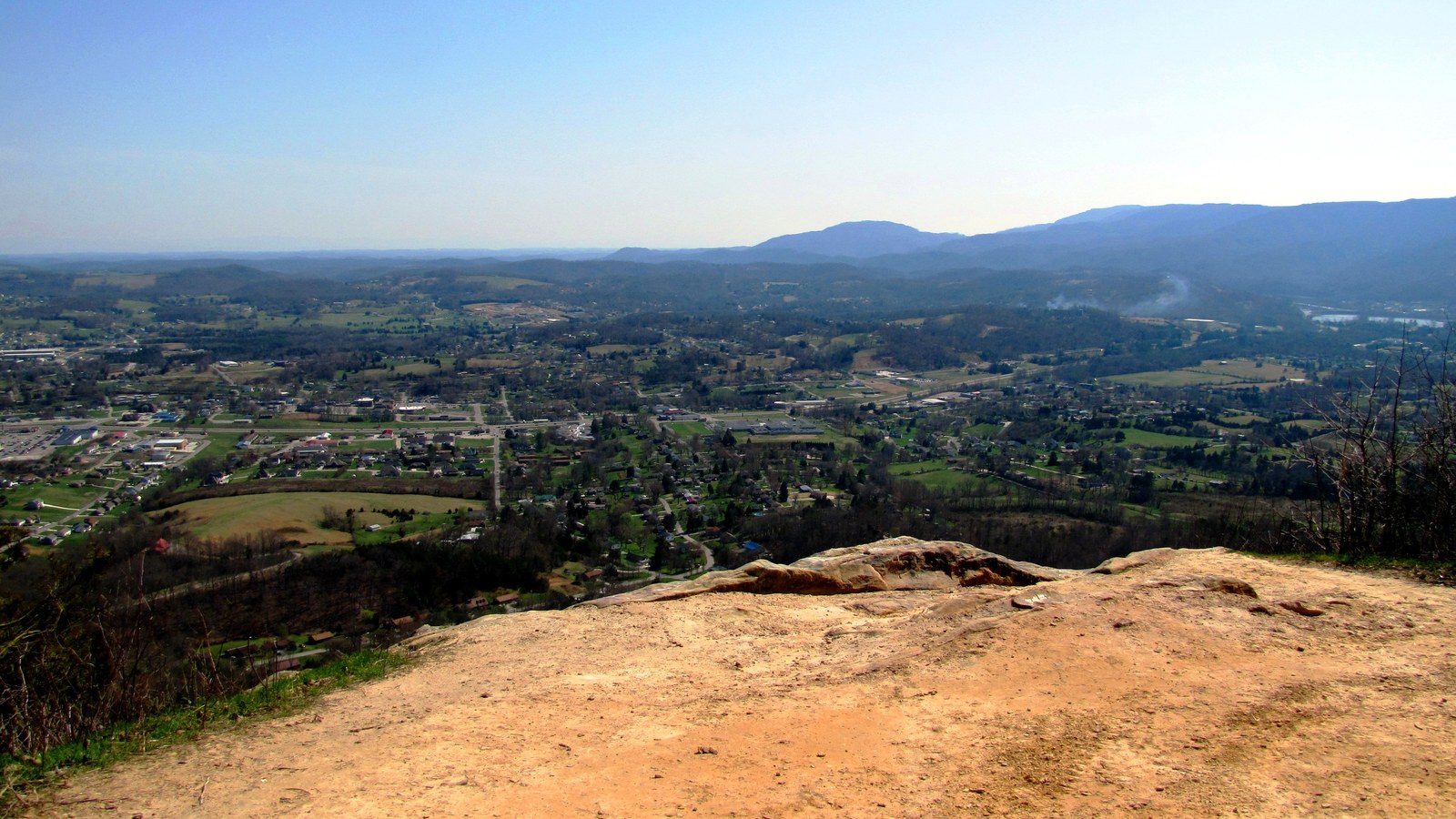
The southernmost segment of the Cumberland Trail is the Tennessee River Gorge segment, which passes through or along the edges of Marion and Hamilton counties. This segment includes the Signal and Edwards Points Section, an 8.2-mile one-way route that begins at Signal Point Park on the Hamilton County side and runs along the rim of the Tennessee River Gorge through Prentice Cooper State Forest.
Signal Point, a National Park Service site within Chickamauga and Chattanooga National Military Park, serves as the trail's southern terminus and offers panoramic views into the gorge. From the overlook, the trail descends roughly 200 feet via a series of ramps and staircases (locally called "the mousetrap," constructed in 1998) into Middle Creek Gorge. The trail then passes through the Rainbow Lake Wilderness Area before entering Prentice Cooper State Forest and Wildlife Management Area.
Edwards Point, at roughly 2.9 miles from Signal Point, provides one of the most dramatic overlooks of the Tennessee River Gorge. Other notable features along this section include Julia Falls (a wet-weather waterfall visible from an overlook) and Lockhart's Arch, a natural rock formation.
Head of Sequatchie
The Head of Sequatchie, located near Pikeville in Bledsoe County, is one of the trail's most significant natural features. It is the point where the Sequatchie River emerges from underground springs at Devilstep Hollow Cave, the only natural water outlet of Grassy Cove's karst drainage system. The half-mile Falcon Warrior Trail at the Head of Sequatchie provides an easy day-hike to the river's birthplace. The Cumberland Trail's visitor center and offices are located nearby.
Ecosystems along the trail in Marion County
The trail's Marion County vicinity passes through several distinct ecological zones. The plateau surface supports oak-hickory forest with an understory of mountain laurel, azaleas, and blueberries. Where the trail descends the escarpment, it enters cove hardwood forests with a mix of tulip poplar, beech, hemlock, birch, and maple in cool, moist microclimates sheltered by sandstone overhangs. Rocky outcrops along the plateau rim support sandstone glade communities with specialized plants adapted to thin, acidic soils. Prentice Cooper State Forest, which the trail crosses, encompasses 24,686 acres and provides habitat for white-tailed deer, wild turkey, black bear, and a variety of neotropical migratory songbirds, including the cerulean warblers studied by the Tennessee River Gorge Trust on adjacent lands.
Construction and volunteers
The trail has been built over several decades through a combination of state investment and volunteer labor. More than 235,000 volunteer hours have been donated to construct and maintain the trail. The Cumberland Trails Conference, a key partner organization, manages the BreakAway Alternative Spring Break program, which brings college volunteers to build trail each year. Land acquisition continues as funding and willing sellers allow, with the goal of connecting the remaining unbuilt segments into a continuous corridor.
The trail is named for Justin P. Wilson, a lawyer who served as commissioner of the Tennessee Department of Environment and Conservation in 1996 and later as deputy governor for policy under Governor Don Sundquist. The naming honored Wilson's role in advancing the trail's development and its designation as a state park.
The trail's volunteer lineage reaches back to the 1960s, when Chattanooga-area hiking clubs began scouting a plateau-edge corridor that could become a regional equivalent to the Appalachian Trail. The Tennessee Trails Association, founded in 1968, organized the earliest long-distance through-hikes along segments of the plateau and built tread in advance of any state involvement. The 1998 Act of the General Assembly designating the route as a state scenic trail effectively ratified decades of unpaid work and gave the Cumberland Trails Conference a legal partner for rights-of-way acquisition. BreakAway volunteers, who spend their spring breaks building and maintaining tread, have logged more than half a million cumulative work hours across Tennessee; the program now counts tens of thousands of participants since its founding in 1997, with the Signal Point base camp at the southern end one of the program's longest-running hubs. The work is slow: trail benching across a sandstone plateau rim often requires breaking rock with hand tools to avoid disturbing rare plants growing on the same ledges.
Access points in and near Marion County
The county's access points fall into three clusters. The Signal Point trailhead, though on the Hamilton County side of Middle Creek, is the primary access for the Marion County segments and connects directly to the Chattanooga region via the Walden Ridge road system. The Prentice Cooper Forest's Tower Road and Indian Rockhouse trailheads give interior access to the Edwards Point, Snooper's Rock, and Mullins Cove loops. The Suck Creek road crossing in far southeast Marion County, where Tennessee State Route 27 descends from Walden Ridge to the river, is the southernmost river-bank approach; at peak river levels, tributary fords along the Suck Creek segment are impassable, and users are directed to alternate routes.
The Cumberland Trail is not currently signed at road crossings inside Marion County's incorporated communities, and parking capacity at the Prentice Cooper trailheads is limited (ten to fifteen vehicles at most interior lots). Backcountry camping is permitted along the Marion County segments with a free TWRA permit required when the trail passes through the Prentice Cooper Wildlife Management Area. The interior forest roads that also serve as trail approaches are gated and closed during managed hunts each November and December; seasonal schedules are posted on the TWRA site.
Recent and proposed segments
Build priority in the 2020s has shifted toward the Suck Creek segment, which will carry the trail from Edwards Point down to the Tennessee River near the old Suck Creek ferry crossing and link the northern and southern halves of the gorge rim. The Mullins Cove segment, slowly acquired in parcels since the mid-2000s, will round out the Marion County loop on the north bank. On the Marion and Grundy county boundary, the Grassy Cove and Head of Sequatchie segments tie the trail's northern plateau miles into the valley corridor the river itself follows south through Marion County. As additional segments open, the Cumberland Trail's Marion County footprint continues to expand well beyond the original Signal-to-Edwards route that was the first opened miles.
Related
The Marion County hiking & trails hub →
About Foster Falls and Denny Cove →
About the Sequatchie Valley →
About the Tennessee River Gorge →
About Prentice Cooper State Forest →
About Marion County overlooks →
Sources
- Wikipedia — Justin P. Wilson Cumberland Trail State Park
- Cumberland Trail State Park, TN State Parks
- Head of Sequatchie, TN State Parks
- Cumberland Trail Conservancy — Signal and Edwards Points Section
- American Hiking Society — Cumberland Trail
- Prentice Cooper State Forest, Tennessee Division of Forestry
- Cumberland Trails Conference (build partner)
- Tennessee Trails Association (1968 founding organization)
- TWRA — Tennessee Wildlife Management Areas (Prentice Cooper WMA covers the trail corridor)