Last updated: April 23, 2026
The same sandstone caprock that makes the Cumberland Plateau escarpment so steep also makes it photogenic. Along both sides of the Tennessee River Gorge and along the rim of the Sequatchie Valley, a line of overlooks, some formally developed, others reached only by trail, gives long-distance views of the Marion County landscape. Some are in Marion County proper; others are in adjacent counties but look directly into the county's reach of the gorge or valley. This page inventories the major overlooks.
Edwards Point
Edwards Point, on Walden Ridge roughly 2.9 miles north of Signal Point along the Cumberland Trail, provides one of the most dramatic overlooks of the Tennessee River Gorge and the Marion County reach of the river. The point sits on Pennsylvanian sandstone caprock at approximately 1,670 feet, overlooking Nickajack Lake, the mouth of Suck Creek, and a direct sightline into Marion County's gorge bottomlands. Edwards Point is a popular hiking destination from the Signal Point trailhead in Hamilton County; the 8.2-mile one-way Signal and Edwards Points section of the Cumberland Trail connects the two. Edwards Point is itself in Hamilton County but the view it offers is almost entirely into Marion.
Julia Falls Overlook
The Julia Falls Overlook, on the same Cumberland Trail segment as Edwards Point, provides a view of the wet-weather Julia Falls and, beyond, the Tennessee River winding through the gorge. The overlook is a short spur off the main Cumberland Trail and is the most photographed vantage point of the Marion County gorge reach on Commons. Technically in Hamilton County at the rim, but looking into Marion County below.
Snooper's Rock
Snooper's Rock, inside Prentice Cooper State Forest on the Marion / Hamilton county boundary, is a widely-known sandstone outcrop on the gorge's north rim that gives an open view up and down the Tennessee River. The name dates to the early 20th century; local legend ties it to moonshiners watching for revenue agents, though no primary source fixes the etymology. Snooper's Rock is accessible via the interior Tower Road in Prentice Cooper and via the Cumberland Trail's Mullins Cove segment. It is one of the more accessible plateau-rim overlooks in the county for visitors unwilling to hike eight miles from Signal Point. A small parking area serves the site; the rim itself is unfenced, and caution is required.
Raccoon Mountain views
Raccoon Mountain, the round-topped ridge southeast of Haletown, supports the TVA Raccoon Mountain Pumped-Storage Plant on its summit and is crossed by several trails that offer long-distance views across the Marion County reach of the Tennessee River. The reservoir on top of the mountain is the pumping reservoir for the TVA facility, and a rim trail gives visitors a distant view west and south into the Marion County side of the gorge, across Shellmound, Guild, and the old Hales Bar site. Raccoon Mountain is in Hamilton County but its rim views look into Marion.
Signal Point and Point Park
Signal Point, at the southern terminus of the Cumberland Trail, is a National Park Service unit within Chickamauga and Chattanooga National Military Park. It offers panoramic views of the Tennessee River Gorge and of Moccasin Bend to the southeast. Point Park, atop Lookout Mountain several miles away, is a separate National Military Park unit with its own gorge view. Neither site sits in Marion County, but both are in the immediate ring of overlooks from which the Marion County river reach is best seen from outside the county. The Battles for Chattanooga (1863) make both points historically significant; see the Civil War page for context.
Jasper Mountain and Sequatchie Valley overlooks
Above the town of Jasper on the plateau rim to the northwest, informal overlooks along US 41 and the associated access roads look down into the Jasper and Kimball valley floor. The old US 41 roadbed climbing Monteagle Mountain crosses several vantage points with views of the Sequatchie Valley's southern end; the newer I-24 alignment provides fewer pull-offs. The Mountain Goat Trail, a rail-to-trail on the plateau between Monteagle and Tracy City, offers scattered vantage points with views south across Marion County's valley end.
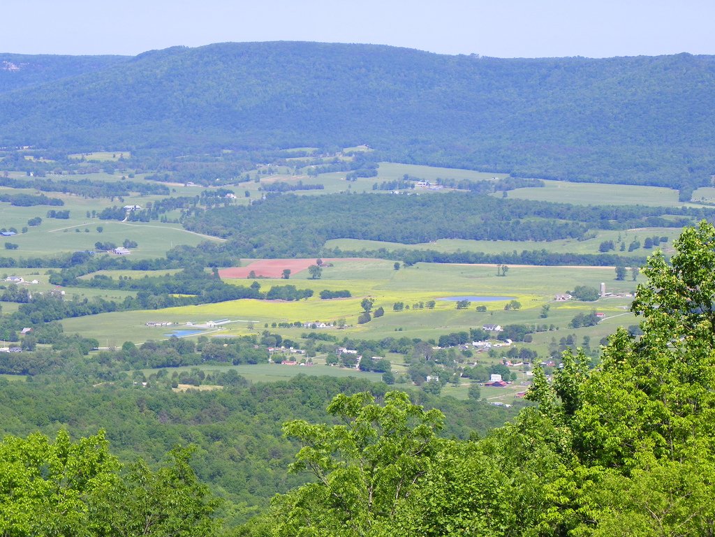
Walden Ridge overlooks (TN-111, TN-27)
The TN-111 and TN-27 crossings over Walden Ridge both provide overlooks with long-distance views of the Sequatchie Valley. The TN-111 overlook on Walden Ridge above the valley (widely photographed, including the main Wikimedia Commons image of the valley) gives a southwest-facing view down the valley toward Whitwell and Jasper. TN-27 crosses Walden Ridge from the Chattanooga side to Dunlap and offers shorter-range pull-offs with views of the valley floor. These are not developed state-park overlooks; they are highway pull-offs with informal parking.
Monteagle Bluff
At the northwestern corner of Marion County, the Monteagle Bluff, the edge of the plateau where I-24 begins its descent into the Sequatchie Valley, offers distant views across the county. Several informal pull-offs along the old US 41 and the Monteagle Mountain Market access roads give views east into the southern end of the Sequatchie Valley and south toward Jasper and Kimball. The Monteagle Sunday School Assembly grounds in adjacent Grundy County include additional rim viewpoints.
Informal and private overlooks
A long list of informal plateau-rim vantage points exists across Marion County, most on private land, some on leased or managed land, a few on state forest interior roads. The Jasper Highlands development on Aetna Mountain, for example, occupies a ridgetop with panoramic views of the Tennessee River Gorge; those views are on private property with access restricted to residents and guests. Several Aetna Mountain overlook spots have historically been used informally but are increasingly fenced or posted as development has proceeded. Hunting leases in the Walden Ridge and Cumberland Plateau interior include ridgetop stands that function as overlooks but are not public access. The state-managed and NPS-managed sites listed above are the overlooks visitors can reach without a landowner's permission.
Related
The Marion County hiking & trails hub →
About the Cumberland Trail →
About Prentice Cooper State Forest →
About the Tennessee River Gorge →
About the Sequatchie Valley →
About Marion County waterfalls →
Sources
- Wikipedia — Tennessee River Gorge
- Cumberland Trails Conference — Signal and Edwards Points Section
- Tennessee Division of Forestry — Prentice Cooper State Forest
- National Park Service — Signal Point
- National Park Service — Lookout Mountain & Point Park
- TVA — Raccoon Mountain Pumped-Storage Plant
- Mountain Goat Trail Alliance