Last updated: April 23, 2026
- Years: 1861 to 1865
- Principal engagement in the county: Battle of Sweeden's Cove, June 4, 1862
- Principal regional campaign: Chattanooga Campaign, October to November 1863, including the Cracker Line supply operation through western Marion County
- Federal fortification: Fort McCook on Battle Creek, summer 1862, shelled out by Confederate Brig. Gen. Samuel B. Maxey on August 27, 1862, briefly held as Fort Maxey, and reoccupied as Fort Thomas during the September 1863 Federal river crossings
- Irregular warfare: bushwhacker raids along Battle Creek and the Cumberland escarpment, 1862 to 1865
- Enslaved population in 1860: about 500 people, about 8 percent of county population; freed by Tennessee's February 22, 1865 state emancipation amendment
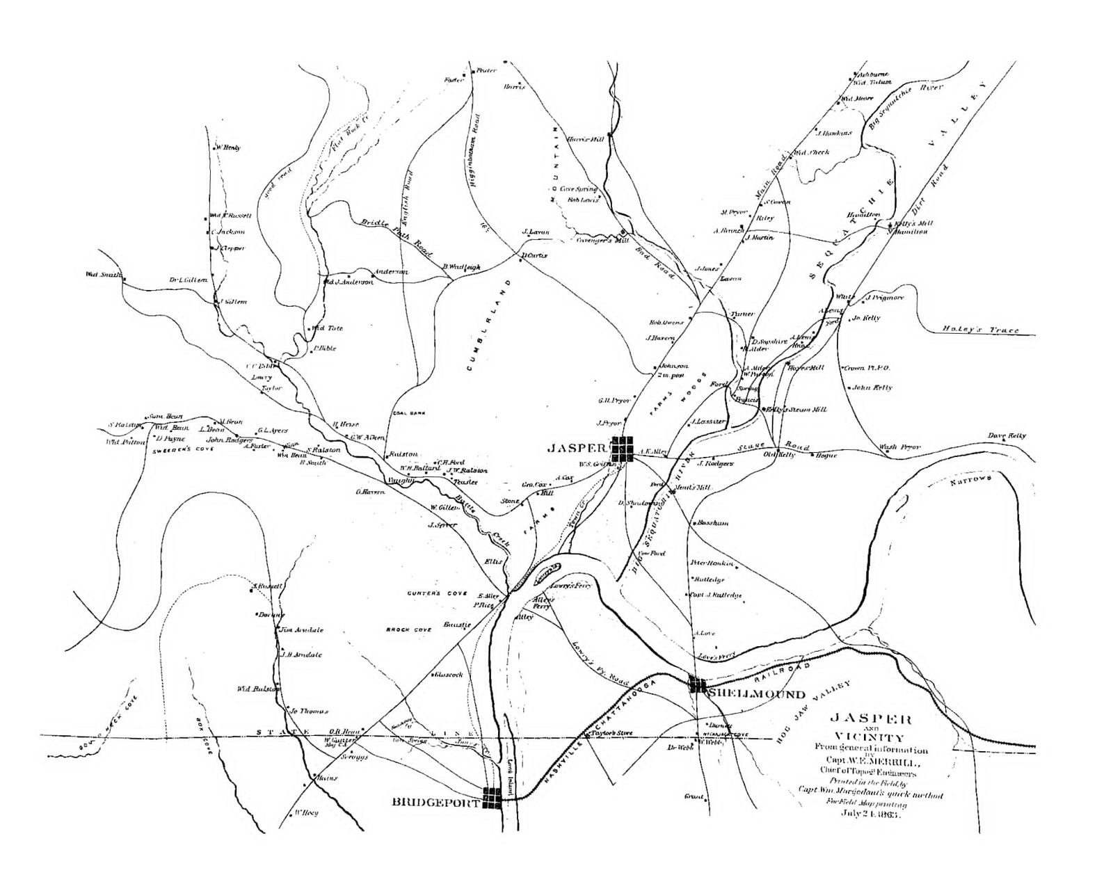
Marion County's Civil War story is shaped by location. The county sits on the southern edge of the Cumberland Plateau, straddles the Tennessee River, and lies on the main corridor between Nashville and Chattanooga. That placement made it a crossroads for troop movements, raids, and skirmishes throughout the war, and it made the county's rugged plateau and gorge country fertile ground for guerrilla fighting once conventional armies had passed through. This page surveys the war in the county from secession in 1861 through the Reconstruction-era handoff in 1865 to 1866. The Battle of Sweeden's Cove and the Cracker Line operation each have dedicated subpages for detailed treatment.
Divided loyalties
Like much of East Tennessee, Marion County held strong Unionist sentiment alongside Confederate support. The county did not rely on a plantation-and-slavery economy to the extent the western parts of the state did, and many Sequatchie Valley families sent sons to both armies. The division cut through neighborhoods and, in some cases, through single households. Bushwhacker violence in the later years of the war was often personal as much as strategic.
The best-known Marion County Confederate figure of the war was Peter Turney, who raised the 1st Tennessee Infantry (Confederate) in April 1861 and led it through Virginia until he was severely wounded at the Battle of Fredericksburg in December 1862. The Turney family's political weight in Marion County and across the Cumberland Plateau made the 1st Tennessee Infantry one of the highest-profile units to recruit in the county. On the Unionist side, a significant but less well-documented flow of Marion County men crossed the plateau north to enlist in the federal forces, joining regiments being raised in Kentucky and Middle Tennessee. Precise unit-by-unit Marion County enlistment figures have not been assembled; the Tennessee State Library and Archives holds the muster rolls.
Enslaved people, emancipation, and Black soldiers
The 1860 census recorded about 500 enslaved people in Marion County, roughly 8 percent of the county's population. Enslaved labor in Marion worked in valley-floor farming along the Sequatchie, on the Tennessee River ferries and boat landings, and in early iron-ore and coal prospecting around what would become Victoria and Inman. Several documented households on the Sequatchie Valley floor, among them members of the Raulston, Standifer, and Turney lines, held enslaved workers at scale through the antebellum period.
Federal Union policy on Black enlistment reached the Tennessee Valley in 1863 and 1864. U.S. Colored Troops regiments organized at Chattanooga, Nashville, and elsewhere in Tennessee included men who escaped from slavery in the Sequatchie Valley and Tennessee River gorge and reached Union lines through Kelly's Ferry, Shellmound, and other crossings. Specific Marion County USCT recruits have not been identified by name; pension files at the National Archives (Record Group 15) would document individual Black Marion County Union soldiers. Tennessee's state emancipation amendment on February 22, 1865 formally freed enslaved people in the county several months before the federal Thirteenth Amendment took effect in December 1865. See the Reconstruction subpage for the post-emancipation period.
Fort McCook on Battle Creek
In the summer of 1862, Federal divisions under Maj. Gen. Alexander McD. McCook and Maj. Gen. Thomas L. Crittenden built Fort McCook, an earthwork on the bluff where Battle Creek meets the Tennessee River. The position was the northern flank of Don Carlos Buell's slow advance from Huntsville toward Chattanooga, and was named for the senior Federal commander on the bluff. By mid-August, with most of Buell's army repositioning to block Bragg's anticipated move on Nashville, the fort was held by a thin garrison under Col. Leonard A. Harris of the 2nd Ohio Infantry, with no artillery of its own. On August 27, 1862, Confederate Brig. Gen. Samuel B. Maxey crossed the river at Bridgeport with the 32nd Alabama and Capt. P. H. Rice's cavalry, repulsed a Federal cavalry attack at Bridgeport, and placed two batteries plus a 24-pounder siege gun on the east bank opposite the fort. The bombardment ran for twelve hours; the Federal garrison, unable to reply, withdrew that night through a mountain path, burning the stores it could not carry. Confederates briefly held the work as Fort Maxey, then moved up the Sequatchie Valley to join Bragg's Kentucky offensive. A year later, in early September 1863, the same earthwork was reoccupied as Fort Thomas by Brig. Gen. John M. Brannan's division of the XIV Army Corps, who built rafts of scrap lumber on the spot and used the position as a Tennessee River crossing for the Chickamauga Campaign. Earthworks remain visible at the site, now part of South Pittsburg River Park. Read the detailed account of Fort McCook →
Battle of Sweeden's Cove, June 4, 1862
Sweeden's Cove, also spelled Sweeten's Cove, sits about seven miles north of South Pittsburg. On June 4, 1862 it was the site of a sharp cavalry engagement, the first significant combat on Marion County soil during the war.
- Union forces: Brigadier General James S. Negley's brigade, including elements of the 79th Pennsylvania Infantry and the 5th Kentucky Cavalry
- Confederate forces: Colonel John Adams, commanding approximately 600 to 800 cavalry that had crossed the Tennessee River from Chattanooga under orders from General P.G.T. Beauregard
- Outcome: a Union tactical victory
- Federal losses: 2 killed, 7 wounded
- Confederate losses: approximately 20 soldiers buried unidentified at the Bean-Roulston Cemetery
Sweeden's Cove was the 79th Pennsylvania's first engagement of the war. For the Union
command the victory opened the way for Negley's subsequent raid toward Chattanooga. For
Marion County, it set the pattern of the war locally: fast cavalry engagements along the
valley, not set-piece battles. Who is actually buried at Bean-Roulston is one of the county's
enduring Civil War mysteries; no complete identification of those graves has ever been
published.
Read the detailed account of the Battle of Sweeden's Cove →
Sweeten's Cove community page →
The Chattanooga Campaign, 1863
The war came closest to Marion County in the fall of 1863, during the Chattanooga Campaign. The major set-piece battles, Lookout Mountain ("the Battle Above the Clouds," November 24) and Missionary Ridge (November 25), were fought just east of Marion County in Hamilton County, but the county sat squarely on the supply and maneuver lines of both armies.
Confederates under Braxton Bragg used Tennessee River crossings near the Marion County stretch of the river. Union General Joseph Hooker's command moved through the Lookout Valley and Wauhatchie area to reach Lookout Mountain. After the Confederate defeat at Missionary Ridge, Federal forces controlled the Tennessee River corridor through Marion County for the remainder of the war.
The siege of Chattanooga that followed Chickamauga in September was broken by the Cracker Line, an eight-day operation in late October 1863 that ran through western Marion County. Brig. Gen. William F. Smith's plan seized a bridgehead at Brown's Ferry on October 27, Hooker's XI and XII Corps marched east from Bridgeport through Lookout Valley and repelled a Confederate night attack at the Battle of Wauhatchie on October 28 to 29, and on October 29 the transport steamer Chattanooga made the first run from Bridgeport up the Tennessee River to Kelley's Ferry on the south bank of the river in western Marion County. Wagons carried rations the short overland distance from the landing over Raccoon Mountain to Brown's Ferry, where a pontoon bridge crossed into the besieged town. The narrow ferry crossing in western Marion County, named for 19th-century settler John Kelly, was for a few weeks one of the single most important supply points in the western theater of the war.
The 780-foot timber trestle at Whiteside, which carried the Nashville & Chattanooga Railroad over the Running Water ravine on Raccoon Mountain, was a critical link in the Federal supply line into Chattanooga. U.S. Military Railroads photographer George N. Barnard documented the rebuilt trestle on January 8, 1864; the resulting image is among the earliest surviving photographs of Marion County. See the Cracker Line subpage for the full account of the October 1863 supply operation that ran through western Marion County.
Raids, guerrillas, and bushwhackers
The rugged plateau and river gorge country that defined Marion County's geography also defined its irregular war. Bushwhacker raids, cavalry sweeps, and retaliatory violence between Unionist and Confederate partisans persisted through 1864 and into 1865, particularly along Battle Creek and in the coves of the Cumberland escarpment. Civilian families in Unionist-sympathizing pockets lived under constant threat of raid and retaliation. The bushwhacker war is less well documented than the conventional campaigns but was in many ways more devastating to local civilians.
Confederate cavalry under Brig. Gen. John Hunt Morgan captured a long Union wagon train in the Sequatchie Valley during his October 1863 raid out of Chattanooga. Union cavalry units of the Army of the Cumberland similarly passed through on patrol, foraging, and courier duty. The pattern, common across East Tennessee, was that no unit held the county for long; military control shifted with the larger campaigns and the season. Marion County farms and homes absorbed the costs of that shifting control in the form of repeated requisition, theft, and occasional violence from both sides. Unionist families in the plateau coves faced particular pressure from Confederate guerrilla bands; Confederate-sympathizing families in Sequatchie Valley towns faced raids by Union scouts and home-guard companies that used Unionist political cover for what was often private score-settling.
Aftermath and the handoff to Reconstruction
Reconstruction-era Marion County was poor and depopulated. Many farms had been stripped of livestock, fencing, and labor; young men on both sides were dead or scattered. Recovery depended heavily on the arrival of the railroad and the capital-intensive iron, coal, and coke operations that would transform the county in the 1870s and 1880s, an industrial boom funded largely by British capital that could not have taken root until peace returned. The formal Confederate surrender in April 1865 did not end the irregular violence on the plateau; the Freedmen's Bureau, the state and federal authorities of the Reconstruction period, and the slow re-establishment of civil courts through 1866 and 1867 all operated in a county still recovering from four years of raids and counter-raids. See the Reconstruction subpage for the fifteen years that followed.
Related
The Battle of Sweeden's Cove, June 4, 1862 →
The Cracker Line, October 1863 →
Reconstruction in Marion County →
About Sweeten's Cove →
About Battle Creek and Fort McCook →
About Whiteside and the Running Water trestle →
About Kelley's Ferry →
The Civil War section of the main history page →
Sources
- Lancaster at War — The Battle of Sweeden's Cove, June 4, 1862
- Civil War Album — Sweeten's Cove, TN
- Wikipedia — Chattanooga Campaign
- Wikipedia — Battle of Lookout Mountain
- Wikipedia — Battle of Missionary Ridge
- National Park Service — Tennessee Civil War Battles
- Tennessee Encyclopedia — Marion County