Last updated: April 27, 2026
- Location: west bank of the Tennessee River at the mouth of Battle Creek, in present-day South Pittsburg, Marion County, Tennessee
- Built: summer 1862, by Union divisions under Maj. Gen. Alexander McD. McCook and Maj. Gen. Thomas L. Crittenden, part of Don Carlos Buell's Army of the Ohio
- Named for: Maj. Gen. Alexander McD. McCook (Union)
- Bombardment: August 27, 1862, by Confederate Brig. Gen. Samuel B. Maxey, twelve hours of artillery fire from the east bank of the Tennessee River
- Federal force on the day of the attack: Col. Leonard A. Harris's 9th Brigade, with about two regiments and a small cavalry detachment after McCook's main column had marched for the Cumberland Plateau
- Confederate force on the day of the attack: 32nd Alabama Infantry under Col. Alexander McKinstry; Capt. P. H. Rice's company of Howard's battalion (Georgia and Alabama cavalry); Capt. S. L. Freeman's Tennessee battery and Capt. G. A. Dure's Georgia battery, with a 24-pounder rifle siege gun worked by Lt. Holtzclaw and Capt. McCreery
- Federal casualties at the fort: 1 killed, 9 wounded
- Federal materiel lost: roughly $30,000 in stores recovered by the Confederates after the night withdrawal, including tents, wagons, ambulances, 32 horses, 4 mules, surgical instruments, sutler's stores, and what Maxey called “some very valuable maps”
- Subsequent names: briefly “Fort Maxey” under Confederate occupation in late August and September 1862; “Fort Thomas” in September 1863 when occupied by Brig. Gen. John M. Brannan's division of the XIV Army Corps under Maj. Gen. George H. Thomas
- Marker on site: Chickamauga Campaign Heritage Trail interpretive marker, erected 2008, in South Pittsburg River Park off U.S. 72 on Jaycee Drive
Fort McCook was a Union earthwork built in the summer of 1862 on the west bank of the Tennessee River, at the bluff where Battle Creek empties into the river in what is now South Pittsburg. It was raised as part of Don Carlos Buell's slow eastward push from Huntsville toward Chattanooga, occupied a position Brig. Gen. Samuel B. Maxey would later call “the key to the Sequatchie Valley,” and held the bluff for less than two months. On August 27, 1862, after most of the Federal force had been pulled back onto the Cumberland Plateau to meet a feared Confederate move on Nashville, Maxey crossed the river at Bridgeport, placed two batteries and a 24-pounder siege gun on the east bank opposite the fort, and shelled it for twelve hours. The garrison, under Col. Leonard A. Harris of the 2nd Ohio Infantry, withdrew that night through a mountain footpath, burning the stores it could not carry. Confederates briefly held the work as Fort Maxey, then moved up the valley to join Bragg's Kentucky offensive. A year later, in early September 1863, the same earthwork was reoccupied as Fort Thomas by Brig. Gen. John M. Brannan's division of the XIV Army Corps, who used it as the staging point for one of the difficult Federal river crossings that opened the road to Chickamauga.
The strategic setting, summer 1862
After the Federal victory at Shiloh in April 1862, Confederate forces under Gen. Braxton Bragg concentrated around Chattanooga while Maj. Gen. Don Carlos Buell's Army of the Ohio moved east through northern Alabama, headquartered at Huntsville. Buell's plan was a slow, rail-supplied advance toward Chattanooga from the southwest, repairing the Memphis & Charleston Railroad as he went and threatening Chattanooga from the south side of the Tennessee River. The Tennessee River line through Marion County was the northern flank of that advance: Bridgeport (in north Alabama, just across the state line) was the railhead, and the bluff at the mouth of Battle Creek, five miles upriver on the west bank, was the obvious place to anchor the Federal hold on the river crossings into the Sequatchie Valley.
Buell, fearing a Confederate strike across the river, dispatched two divisions to the Battle Creek bluff in July and August 1862: Maj. Gen. Alexander McD. McCook's division and Maj. Gen. Thomas L. Crittenden's division. The two divisions built the earthwork on the bluff and named it Fort McCook after the senior Federal commander on site. The work was substantial: Maxey, who would later capture it, described it in his after-action report as “a splendidly constructed field work, admirably executed.”
The fort thinned out, August 1862
The position did not stay garrisoned in strength. By mid-August 1862, Bragg was preparing his Kentucky offensive, and Confederate cavalry probes across the Tennessee gave Federal intelligence the impression that the main Confederate move would be aimed at the recapture of Nashville. Acting on what the 2008 Chickamauga Campaign Heritage Trail marker on the site calls “faulty intelligence,” McCook left Battle Creek for Altamont and Tracy City to block Bragg's anticipated move. Buell began shifting Federal units west and north to cover Nashville. Col. Leonard A. Harris, commanding the 9th Brigade and his own 2nd Ohio Infantry, was left in charge of Fort McCook with two regiments and a small cavalry detachment, with orders to gather information on Confederate troop movements. Harris was subsequently directed to send one of his infantry regiments and all of his artillery to McCook on the plateau, leaving the fort with reduced infantry strength and no artillery of its own.
The August 27, 1862 attack
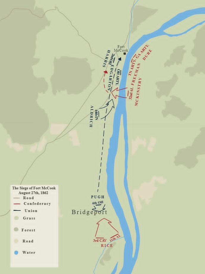
On the morning of August 27, 1862, Capt. P. H. Rice, commanding Company A of J. R. Howard's battalion (Georgia and Alabama cavalry), forded the Tennessee about two and a half miles below Bridgeport on Maxey's orders and moved on the town. He found that the Federal garrison at Bridgeport had evacuated the night before. Maxey then ordered the 32nd Alabama Infantry under Col. Alexander McKinstry to wade across the river at the same point. The 32nd Alabama, in Lt. John L. Chandler's account, crossed in water up to the men's armpits, with retreat impossible if the crossing failed.
Word that the Federals were approaching Bridgeport reached Maxey almost as soon as the 32nd Alabama was across. Col. Harris had ordered Maj. Pugh of the 4th Ohio Cavalry down to Bridgeport with cavalry to attack the Confederate force. McKinstry's regiment, posted in line of battle behind the crest of a commanding hill in town, repulsed the Federal cavalry in a sequence of three close-range volleys, with a company of Enfield-rifle-armed men under Lt. A. Sellers concealed in the center as a reserve. The 4th Ohio Cavalry fell back toward Battle Creek.
While the Bridgeport fight was unfolding, Maxey's batteries, under Capt. S. L. Freeman (Tennessee artillery) and Capt. G. A. Dure (Georgia artillery), with a 24-pounder rifle siege gun, opened on Fort McCook from the east bank about 800 yards across the river. The bombardment continued, with breaks only to let the guns cool, for twelve hours. Lt. Holtzclaw of Dure's battery worked the siege gun for most of the day; Capt. McCreery handled it part of the time. Inside the fort, the garrison had no way to reply, the Federal artillery having been withdrawn earlier in the month. Casualties at the fort during the bombardment were one killed and nine wounded, among them Harris's acting assistant adjutant-general, Vandegrift, and his orderly, Henry Norris.
Harris began preparing to withdraw as soon as it became clear that the Federal cavalry could not retake Bridgeport and that the Confederate batteries could not be silenced from the fort. He placed three companies of infantry, plus the cavalry returning from Bridgeport, on a small mountain path that joined the main Decherd road about eight miles from the fort, with orders to hold it “to the last extremity.” In the evening, Federal scouts reported that the road through Jasper was still open. Harris loaded his most valuable stores into the wagons that remained, piled the rest for burning, cut up the tents, and wrapped the wagon wheels in the canvas to muffle the sound. As darkness fell, a company of riflemen was placed in the rifle pits to cover the withdrawal. Capt. Mathews of the 4th Ohio Cavalry applied the torch to the remaining stores about an hour after the column had cleared the fort. Harris reached Decherd on August 29 and reported to Buell.
From the Confederate side, Maxey saw the work go quiet about two o'clock in the morning, with the burning stores visible from across the river. He moved cavalry across at first light. The Confederate force took possession of the fort and recovered roughly $30,000 in Federal stores: commissary supplies, ordnance, quartermaster's stores, clothing, all of the tents, 32 horses and 4 mules, wagons and ambulances, surgical instruments, sutler's goods, officers' trunks, the post commander's papers, and what Maxey, in his report, called “some very valuable maps.” Maxey's report named Cols. McKinstry and Henry Maury, Capts. Rice, Freeman, and Dure, and Lts. Holtzclaw and Sellers as having done their whole duty. Bragg's headquarters at Pikeville issued General Orders No. 2 on September 2 congratulating Maxey for “one of the most dashing achievements of the day.”
Voices from the fort and the river
Three first-person accounts survive from August 1862, two of them from inside the fort or on the river bank in the days before the bombardment, the third from the Confederate commander writing four days afterward.
Pvt. Daniel Rowe, 44th Indiana Infantry, Company H, wrote home about an encounter at the river bank in the days before the August 27 attack:
“There is lots of them on the other side of the river. I was down to the river yesterday bathing and washing some clothes and the secesh came down to the river on the other side and hollered to us and asked us to come over. We told him that it would not pay. We asked him what regiment he belonged to and he said 96th Georgy. I told him that Georgy did not have that many fighting men and he said that it had a damn sight more though. He said that we would see them over here before long and we told him that we have seen them run too and he said that he expected we had but it was after us that they run. They are very saucy. The river is not very wide. I think that I could hit a man almost every shot but there is not any shooting done.”
Lt. Angus Waddle, 33rd Ohio Volunteer Infantry, was inside the fort during the bombardment. His memoir Three Years with the Armies of the Ohio and the Cumberland, published after the war, contains one of the few first-person Federal accounts of the day:
“The fort which we had regarded as our protection soon showed itself a delusion and a snare. As I said before, it was built upon the side of the mountain, but, unfortunately for us, was directly exposed to the enemy and we soon found that it was the most insecure place in the neighborhood. Shell after shell came bursting in our midst and as the fragments hurtled through the air, we soon found that it was not good for us to be there. By leaving the fort, however, and getting on the wrong side of the embankment, a place of comparative security was found and thither a pilgrimage soon began. The chaplain showed his orthodoxy by uniting his faith with the works and the followers of his good example were more numerous on that occasion than they had generally been when he preached the faith alone. As we were without artillery and the enemy far beyond reach of musketry, there was nothing for us to do but take our medicine and it came in no homoeopathic doses.”
Maxey's report to Department headquarters on August 30 closed with this assessment of the position:
“The work out of which the enemy was shelled is a splendidly constructed field work, admirably executed; is the key to the Sequatchie Valley, and its possession completely breaks the enemy's chain up the Tennessee River. With cavalry to operate from that point toward Stevenson and Huntsville the enemy could be kept in constant alarm.”
Fort Maxey, August to September 1862
The Confederates held the work for several weeks after the August 27 attack. They renamed it Fort Maxey in honor of the commanding general. The position was not meant as a permanent garrison: by early September, Bragg's Kentucky offensive was under way, and the Confederate force at Fort Maxey moved north up the Sequatchie Valley to join the larger movement that would carry Confederate arms as far as Munfordville and Perryville in Kentucky before being turned back in early October. By the time Buell's Federal forces had repositioned to follow Bragg into Kentucky, Fort Maxey was an unoccupied earthwork on the bluff. It would remain so for almost a year.
Fort Thomas: Brannan's crossing, September 1863
In late August and early September 1863, Maj. Gen. William S. Rosecrans's Army of the Cumberland moved from Middle Tennessee toward the Tennessee River for the campaign that would end at Chickamauga. The XIV Army Corps, under Maj. Gen. George H. Thomas, crossed at several points on the western flank, with Brig. Gen. John M. Brannan's 3rd Division assigned to cross at the mouth of Battle Creek. Brannan reoccupied the old earthwork. Federal records and the Chickamauga Campaign Heritage Trail marker on the site call it Fort Thomas in this phase, naming it for the corps commander.
Brannan had no pontoon train assigned to his division. Instead, his men built a pontoon bridge across Battle Creek itself with whatever timber was on hand, and constructed rafts of scrap lumber to ferry the division over the much wider Tennessee. Brannan reported afterward:
“I commenced to cross with the entire division and completed the crossing on the 2d of September, with the ammunition and baggage trains, having previously sent the supply train by way of Bridgeport. The crossing was rendered most tedious and protracted from having no transportation further than the rafts hastily constructed from such lumber as we could pick up, rendering it necessary in many instances to partially unload the wagons before placing them on the rafts.”
One Federal soldier was killed during the crossing. The man, attempting to keep hold of a mule on a raft midstream, was struck on the head by the animal as it thrashed and was dragged overboard. The body was recovered, and he was buried with military honors beside the river at Battle Creek, the only known wartime burial on the Fort McCook ground.
Once Brannan's division was across, the position dropped out of operational use. The river crossings shifted east as the Federal army concentrated for the move into Georgia, and the major engagements of the campaign, Chickamauga in mid-September, Lookout Mountain on November 24, and Missionary Ridge on November 25, were fought far enough from the Battle Creek bluff that the earthwork did not need to be regarrisoned. See the Cracker Line page for the western Marion County supply operation that ran through Bridgeport, Kelley's Ferry, and Brown's Ferry in late October 1863, and the Civil War in Marion County page for the broader county narrative.
The site today
The Fort McCook earthworks survive in part on the bluff, much reduced by erosion, the railroad cut that runs along the river just below, and a century and a half of weather. The site is now part of South Pittsburg River Park, off U.S. 72 on Jaycee Drive, and is publicly accessible. A Chickamauga Campaign Heritage Trail interpretive marker, erected in 2008, stands inside the park near the original location of the fort, with the viaduct of the old Southern Railroad grade visible in the background. The marker is the most detailed on-site treatment of the action and gives the outline that this page expands on.
A note on the contributing research
The regimental movement map of August 27, 1862 above was drafted by Carden Brown from his own research on Fort McCook and is used here with his permission. The Pvt. Daniel Rowe letter of summer 1862 was supplied by Carden from his correspondence collection. The on-site geographic detail and several of the regimental connections that this page uses to thread the OR reports together with the ground itself are also Carden's.
Related
The Civil War in Marion County →
The Battle of Sweeden's Cove, June 4, 1862 →
The Cracker Line, October 1863 →
Battle Creek community page →
South Pittsburg community page →
The Civil War section of the main history page →
Sources
- TSLA Civil War Sourcebook — August 27, 1862, Skirmish at Fort McCook on Battle Creek (Harris, Maxey, Chandler, Buell, Waddle reports from OR, Ser. I, Vol. 16, pts. I and II)
- HMdb — Fort McCook Historical Marker (Chickamauga Campaign Heritage Trail, erected 2008)
- South Pittsburg Historic Preservation Society — Marker placement page for the 2008 Fort McCook installation
- FortWiki — Fort McCook (2)
- Tennessee Vacation — Fort McCook Site
- Wikipedia — Samuel Bell Maxey
- Wikipedia — Alexander McDowell McCook
- Wikipedia — Thomas L. Crittenden
- Wikipedia — John Milton Brannan
- Wikipedia — George Henry Thomas
- Wikipedia — Don Carlos Buell
- Wikipedia — Chickamauga Campaign
- Community contribution — Carden Brown, 2026: regimental movement map of August 27, 1862, and the Pvt. Daniel Rowe (44th Indiana Co. H) letter excerpt.