Last updated: April 23, 2026
- Type: Historical community and river ferry crossing (inactive)
- Location: Western Marion County, on the south bank of the Tennessee River north of the present U.S. 41 / TN-27 corridor, near the present Guild community and Lookout Valley line
- Named for: John Kelly (1779–1845), first clerk of the Marion County Circuit Court, who settled the site and operated the original ferry
- Ferry operated: From the early 1800s until 1952, when the crossing was closed after 150 years of use
- Civil War role: River terminus of the Cracker Line supply route that broke the Confederate siege of Chattanooga in late October 1863
- Surviving landmark: Kelly's Ferry Cemetery, added to the National Register of Historic Places on November 15, 2006 (ref. #06001037)
Setting
Kelly's Ferry sat on the south bank of the Tennessee River in western Marion County, at a reach where the river bends around the foot of Raccoon Mountain on its way out of the Tennessee River Gorge. The ferry crossed from the Marion County side to the Hamilton County side at a point roughly eight miles by wagon west of Chattanooga and about forty-five river miles upstream of Bridgeport, Alabama. The ferry road climbed up and over Raccoon Mountain to meet the main Chattanooga road near Brown's Ferry, giving wagons a short overland cut around the great bend of the river that cost steamboats many more miles of travel.
The community that grew up around the crossing was a small one: the ferryman's house, a store or two, a handful of farmsteads on the bottom land, and the family burial ground that still survives above the lake line. It never had a post office of its own. The name traces to John Kelly, the first clerk of the Marion County Circuit Court, who settled the site in the first years of the county's existence and opened the ferry. The 1824 Marion County landowners' roll records no fewer than six Kelly heads of household in the county, and the family anchored the west-Marion stretch of the river through the 19th century.
Cherokee and pre-Cherokee presence
The reach of river at Kelly's Ferry carried thousands of years of use before any ferry was chartered. The gorge corridor and its tributary mouths preserve Archaic and Woodland fishing and hunting camps (roughly 8000 BC to AD 900), and in the Mississippian period (about AD 900 to 1600) villages along the river flats upstream and downstream were part of the broad Tennessee Valley mound-building network. The valley's prehistory is traced on the In the Beginning page.
By the late 18th century, the stretch of river that includes the Kelly's Ferry crossing was under the control of the Chickamauga (Lower) Cherokee towns of Nickajack and Running Water, founded by Dragging Canoe in 1779 a short distance downstream. Cherokee households used the bottomlands and island heads along this reach for corn grounds, hunting camps, and river travel. Both Lower Towns were destroyed in the 1794 Nickajack Expedition, and the river valley was opened in stages to Anglo-American settlement over the following generation. A Cherokee community continued to live along the river into the 1820s, and the last families were pushed out by the forced removal of 1838. Three detachments of Cherokee people, together numbering in the thousands, crossed or camped near this stretch of the river during the summer and fall of 1838 on their way west along the Trail of Tears. The Cherokee Nation, today a sovereign nation headquartered in Oklahoma, traces a portion of its ancestry through the families who once held this reach of the Tennessee.
The Kelly family and the ferry
John Kelly, born June 2, 1779, settled on the south bank of the Tennessee River in what became Marion County in the county's founding decade. When the county was organized in 1817, Kelly was appointed the first clerk of the Marion County Circuit Court, an office he held into the 1820s. He established a ferry across the river at the site, which carried his name from the beginning, and he lived at the ferry site until his death on November 26, 1845. He is buried in the family cemetery above the landing.
The ferry was one of a string of 19th-century crossings that tied the south bank of the Tennessee to the north bank and to the roads leading into Chattanooga before any bridges existed in this reach. Kelly's Ferry, Brown's Ferry, and Williams' Island crossing each carried part of the traffic that used the south-bank road through Lookout Valley. The ferry was a flatboat pulled across the current, the standard technology on this reach of the river well into the 20th century. It continued to operate under a series of family and private owners, closing only in 1952 after about 150 years of service.
The Cracker Line, October 1863
In the autumn of 1863, after the Union defeat at Chickamauga in September, the Army of the Cumberland retreated into Chattanooga and was quickly cut off. Confederate forces under Braxton Bragg held Lookout Mountain and Missionary Ridge, dominated the south bank of the Tennessee River between Chattanooga and Bridgeport, and closed the main rail and wagon routes into the town. Supplies for the Union army had to travel a 60-mile mountain detour north of the river through the Sequatchie Valley, where Confederate cavalry raids under Joseph Wheeler destroyed hundreds of wagons in early October. Rations inside Chattanooga ran short, horses and mules starved by the thousands, and the army was within weeks of collapse.
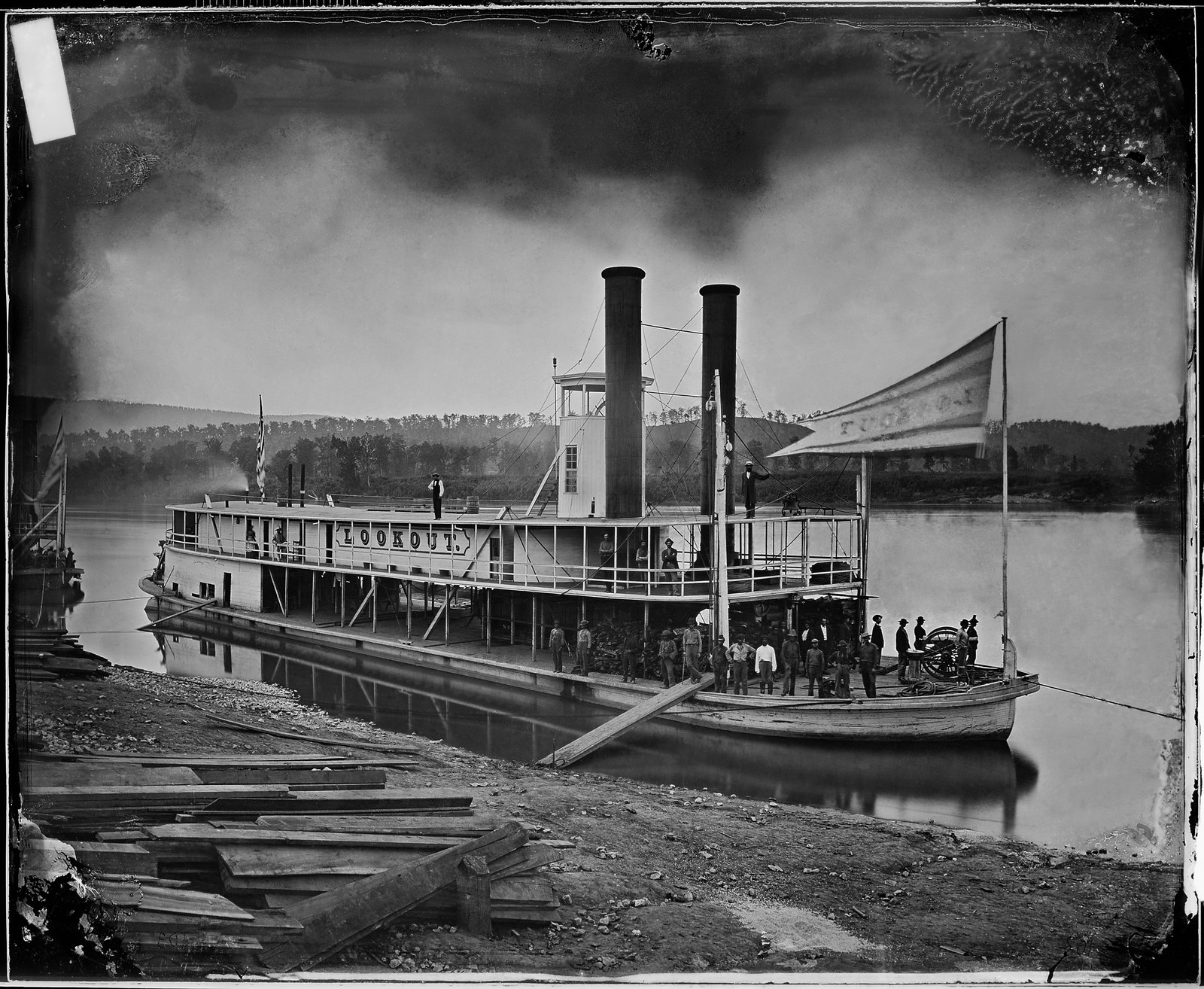
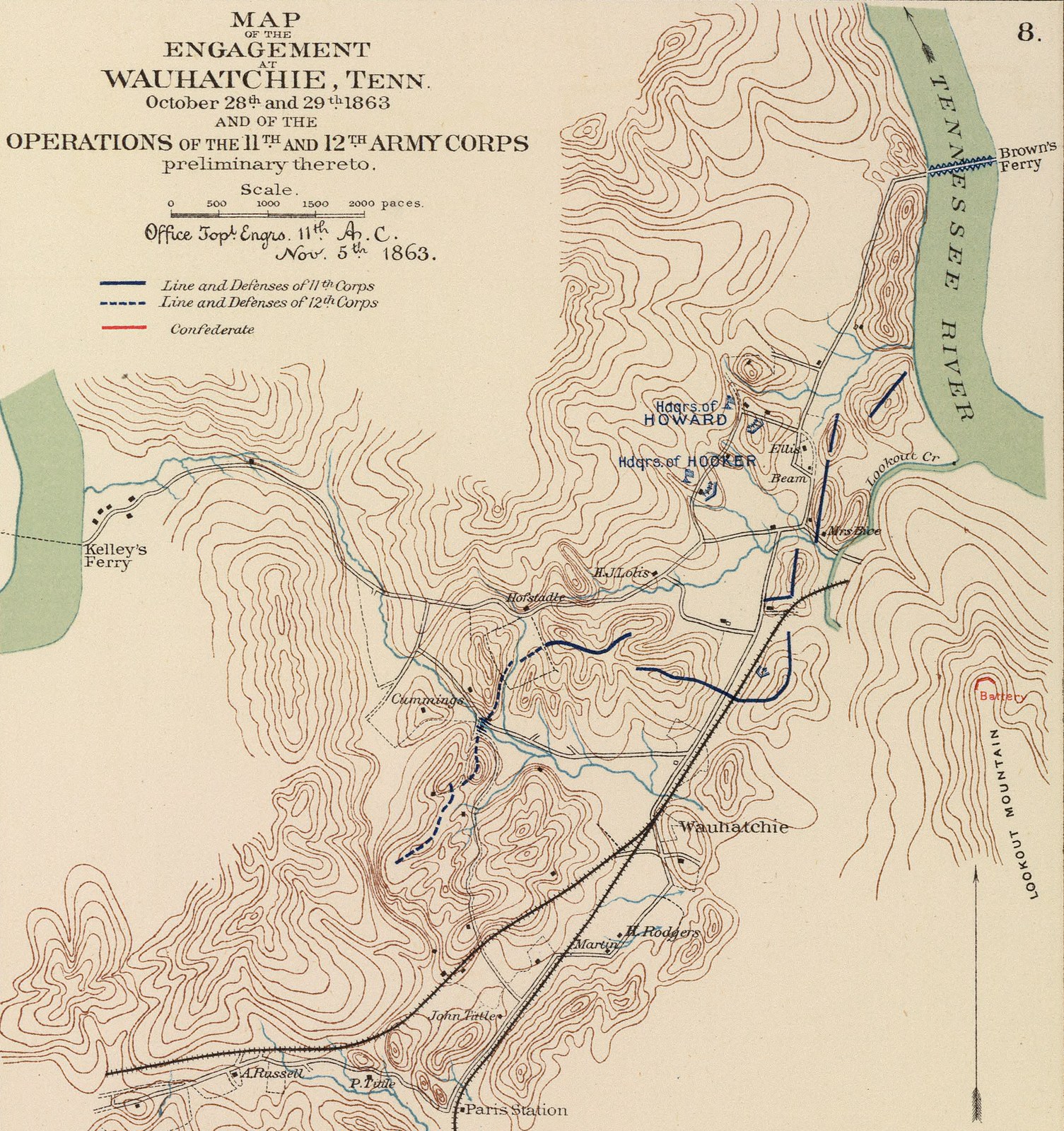
The plan that broke the blockade was drafted by Brigadier General William F. “Baldy” Smith, the newly arrived chief engineer of the Army of the Cumberland. Smith proposed seizing a bridgehead at Brown's Ferry on the south bank west of Lookout Mountain, linking up with Joseph Hooker's XI and XII Corps marching east from Bridgeport through Lookout Valley, and running supplies by steamboat up the Tennessee from Bridgeport to a river head at Kelley's Ferry (the 1860s spelling). Wagons would then carry the rations the short distance over Raccoon Mountain to Brown's Ferry and across a pontoon bridge into Chattanooga. The scheme replaced a 60-mile wagon haul with an 8- to 10-mile one.
Ulysses S. Grant approved the plan on arriving in Chattanooga on October 23, 1863. On the morning of October 27, pontoon-borne troops of William B. Hazen's brigade took Brown's Ferry in a surprise predawn landing. Hooker's column reached Wauhatchie in Lookout Valley that evening and repelled a Confederate night attack on October 28 to 29 at the Battle of Wauhatchie, securing the Kelley's Ferry road. On October 29, a newly built Union transport steamer, the Chattanooga, assembled at Bridgeport under quartermaster Arthur Edwards from the hull of a captured riverboat and from sawn timber and machinery shipped in by rail, made the first run up the Tennessee to Kelley's Ferry with a full cargo of rations. A small Union quartermaster fleet, including the Look Out and later the Bridgeport, Missionary, and Paint Rock, joined the run over the following weeks.
Troops in Chattanooga nicknamed the supply line the Cracker Line, for the hardtack crackers that were the first thing to reach them through it. The siege was effectively broken within days. The Cracker Line fed the Union army through the November 23 to 25 battles of Lookout Mountain and Missionary Ridge, after which Bragg's army was driven off the heights and Chattanooga became the forward base for the 1864 Atlanta Campaign. The narrow ferry crossing in western Marion County was, for a few weeks in the fall of 1863, one of the single most important points on the western map of the Civil War.
Post-war decline and inundation
After the war the Kelly's Ferry crossing returned to its pre-war function as a local river ferry. A wagon road continued to climb Raccoon Mountain from the landing, and the ferry carried farm traffic, livestock, and local travelers across to the Hamilton County side. The arrival of the Nashville, Chattanooga & St. Louis Railway through the gorge on the north bank in 1854, and the later addition of highway bridges downstream, slowly drained the ferry's commercial role. By the early 20th century it was a crossing of last resort for farmers and fishermen rather than a through route.
The 1913 completion of Hales Bar Dam downstream raised the Tennessee to pool elevations that flooded the lowest parts of the ferry landing and narrowed what remained of the community. The ferry itself was finally retired in 1952, closing a crossing that had operated without a bridge for roughly a century and a half. The 1967 completion of TVA's Nickajack Dam, replacing Hales Bar, raised the river to its modern pool level of about 633 feet above sea level, drowning the rest of the ferry landing and the bottomland farmsteads along the former ferry road. What had been a working river community became a name on the map, a cemetery on the bluff, and a stretch of shoreline inside the Nickajack Lake system.
Kelly's Ferry Cemetery
The enduring footprint of the community is Kelly's Ferry Cemetery, the family and community burying ground that sat on higher ground above the landing and so survived the impoundments. The cemetery was established in the 1830s by John Kelly on his own land, and the earliest surviving interment dates to 1838. John Kelly himself was buried here in November 1845, and the cemetery continued in use through later generations of the Kelly family and their neighbors.
On November 15, 2006, the cemetery was added to the National Register of Historic Places (reference number 06001037) for its association with early Marion County settlement and with the Cracker Line operation of 1863. It is the only individually listed National Register cemetery in Marion County, and remains the only physical landmark that traces directly back to the settlement that once gave the crossing its name. A dedicated cemetery subpage covers the bluff site, the Kelly family genealogy, the surname distribution, and the National Register listing in detail.
Present day
Kelly's Ferry survives today as a place name attached to a stretch of Nickajack Lake shoreline, a boat ramp, a road climbing Raccoon Mountain, and the NRHP-listed cemetery. The small community at the ferry site is gone, inundated or depopulated by the 20th-century dams, but the name continues to be used by local fishermen, mappers, and historians. The Cracker Line associations make Kelly's Ferry one of the most documented single points in Marion County's Civil War history, even though almost nothing of the 1863 landing survives above water.
Related
The Cracker Line, October 1863 →
Civil War in Marion County →
Haletown & Guild →
Tennessee River Gorge →
Hales Bar Dam →
Cherokee Lower Towns →