Last updated: April 22, 2026
- Type: Unincorporated community and census-designated place (CDP)
- Location: Southern Marion County, along Interstate 24 and Tennessee State Route 134, between Chattanooga and Haletown, just north of the Tennessee-Georgia state line
- Elevation: 797 feet (243 m)
- Area: 3.96 square miles
- 2020 population: 274 (density 69.3 per sq mi)
- Named for: Col. James Anderson Whiteside (1803–1861), Chattanooga attorney and railroad promoter
- ZIP code: 37396
Whiteside is a small community at the southern tip of Marion County, wedged into the narrow sliver of land between the Tennessee River Gorge and the Georgia state line. It grew around a stop on the East Tennessee and Georgia Railroad in the 1850s, took its name from one of the line's principal promoters, and became one of the most photographed points on the Union Army's supply chain during the Civil War. A 780-foot wooden trestle bridge over Running Water Creek, burned and rebuilt in the course of the Chattanooga campaign, is the community's best-documented feature from the 19th century.
Setting
Whiteside sits at about 800 feet in elevation, in the valley floor between Raccoon Mountain to the north and the Tennessee state line to the south. Running Water Creek, which gives the area its oldest surviving place name, flows through the community on its way down to the Tennessee River at the mouth of the gorge. Interstate 24 runs east-west along the valley floor, crossing the creek on a modern bridge not far from the alignment of the 19th-century railroad. Nickajack Lake lies a few miles to the west, and the Georgia town of Lookout Mountain is just across the line to the south.
Cherokee and pre-Cherokee presence
The Running Water drainage had been in continuous Indigenous use for thousands of years before it was a railroad stop. The valley along the creek and its rockshelters on the surrounding ridges have produced archaeological evidence of Archaic and Woodland occupation (roughly 8000 BC to AD 900), and the lower creek flats, like the wider gorge, fell within the Mississippian cultural sphere between about AD 900 and 1600. The landscape here, narrow valley floor wedged between steep ridges with a creek running down to the Tennessee, was a natural travel and camp corridor long before it carried rails.
In the late 18th century, the valley was part of the Cherokee homeland. The Cherokee name for the general Running Water area was Amogayunayi; the Cherokee town of Running Water proper was a Chickamauga stronghold founded by Dragging Canoe in 1779, a few miles downstream near the mouth of Running Water Creek at the Tennessee River (see the Nickajack and Running Water page). The creek bottom past modern Whiteside was part of the hunting, travel, and fishing range of that town until it was destroyed in the 1794 Nickajack Expedition. The Whiteside community, by contrast, is a 19th-century railroad-era settlement that took the creek's name as one of its earliest railroad-stop designations before being renamed for Col. Whiteside.
Cherokee presence in the region did not end in 1794. Under the Treaty of 1819, a handful of Cherokee families took 640-acre reservations along Battle Creek and neighboring bottoms on the north side of the river, and Cherokee households continued to work ferry crossings and farms through the first generation of Anglo-American settlement. The remaining Cherokee community in the county was forcibly removed along the Trail of Tears in 1838. The Cherokee Nation, today a sovereign nation headquartered in Oklahoma, traces part of its ancestry through the families of the Lower Towns.
Col. James A. Whiteside and the railroad
The community's modern name comes from Col. James Anderson Whiteside (1803–1861), one of Chattanooga's foundational 19th-century figures. Whiteside was born near Danville, Kentucky, trained briefly as a physician, read law at Pikeville, and was elected to the Tennessee legislature at twenty-four. In 1838 he moved his family to Ross's Landing, the settlement that would become Chattanooga, and spent the rest of his career promoting the railroads and hotels that built the city.
Whiteside was an early promoter of the Nashville and Chattanooga Railroad, the line that ran west from Chattanooga along the valley floor and crossed the Tennessee–Alabama state line at Bridgeport. He introduced the bill that chartered the railroad in December 1845, and the through line was completed to Chattanooga in 1854. In 1857 he left Chattanooga for Nashville to serve as vice-president of the railroad, which was reorganized as the Nashville, Chattanooga & St. Louis Railway in 1873. He died on November 12, 1861, early in the Civil War. The railroad stop in Marion County had been carrying station names of Aetna, Etna, and Running Water; within a few years of his death, the community around the stop was known as Whiteside.
The Running Water trestle and the Civil War
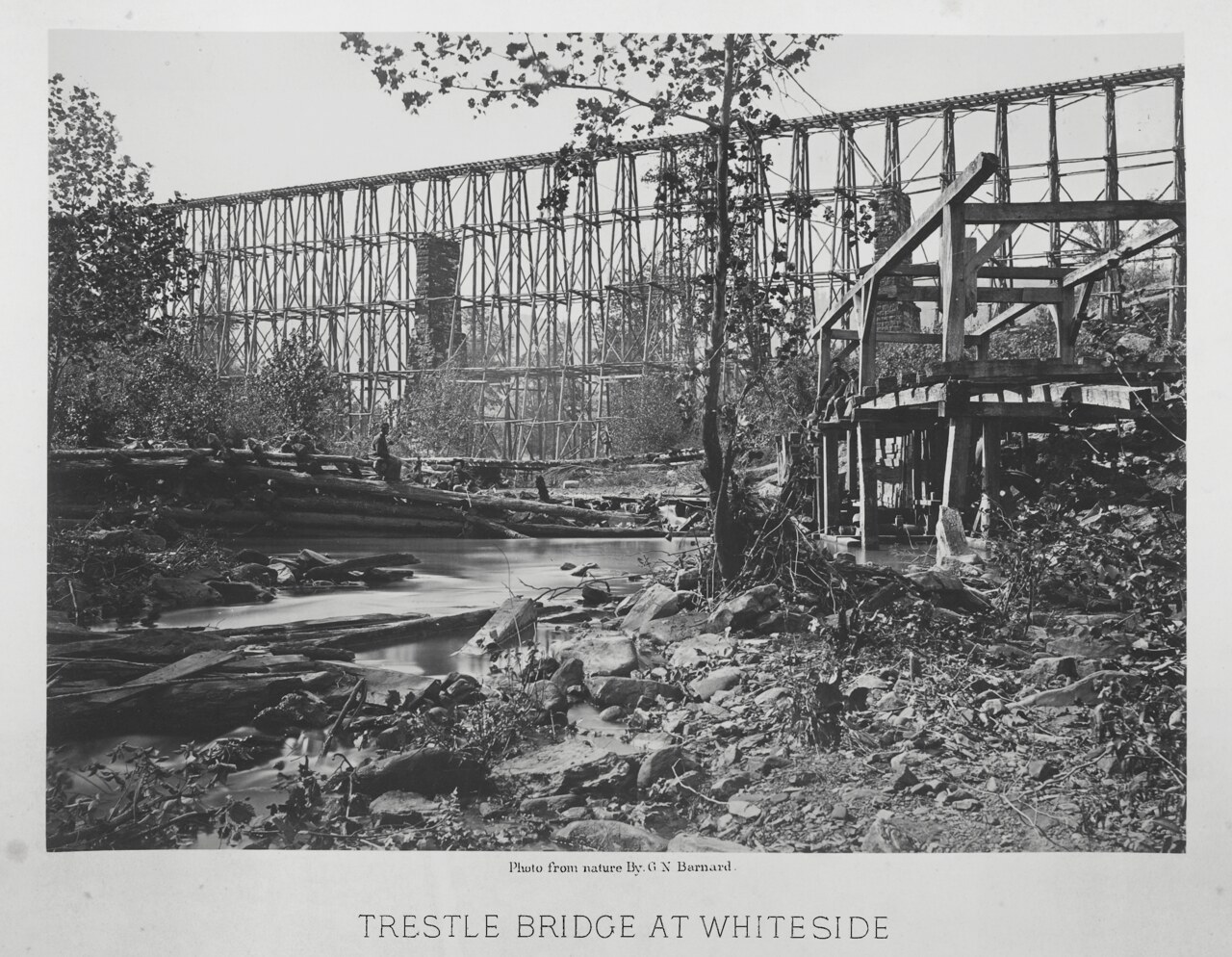
In the 1863 Chattanooga campaign, the railroad through Whiteside became one of the most important supply lines in the Union advance. Confederate forces destroyed the original wooden trestle bridge over Running Water Creek as they retreated. In December 1863 and January 1864, the 1st Michigan Engineers rebuilt it: a four-tiered timber viaduct 780 feet long, carrying the U.S. Military Railroads track across the creek at a substantial height above the valley floor.
George N. Barnard, the Army photographer assigned to document the campaign, recorded the rebuilt bridge on January 8, 1864. His photograph, which survives in the collection of the Library of Congress and the Art Institute of Chicago, shows the bridge, the surrounding guard camp, and the steep terrain of the valley, and is the single most reproduced image of wartime Whiteside. A second timber bridge at the same location was washed away in the flood of 1867, and a series of successor bridges rebuilt through the early 20th century carried the line until roughly 1924, when heavier replacement structures finally superseded the wooden viaduct era.
The railroad has operated continuously through Whiteside since the 1850s, with the line passing to NC&StL control after the war and subsequently to the Louisville and Nashville and CSX systems. A 986-foot railroad tunnel built in this area in 1858 and later associated with Col. Whiteside's name was donated in 1968 to the Tennessee Valley Railroad Museum; the structure was added to the National Register of Historic Places in 1978 (NRHP 78002595). Sources differ on the tunnel's exact location, with some accounts placing it nearer the Chattanooga end of the line.
Present day
Whiteside today is a small, rural community of just under 300 people. The 2020 census counted 274 residents across 3.96 square miles, giving the CDP a density of roughly 69 people per square mile. The state-designated area covers the modern hamlet along TN-134 and the corridor of Interstate 24. The landscape is a mix of small homes, pasture, and forested ridge; the Georgia state line is visible at the end of some southbound driveways. A community church, Whiteside Baptist, anchors the settlement today.
Related
Tennessee River Gorge →
Nickajack and Running Water (Cherokee towns) →
The Cracker Line, October 1863 →
The Civil War in Marion County →
Haletown and Guild →
Transportation and railroads →
Sources
- Wikipedia — Whiteside, Tennessee
- Gaston: James A. Whiteside, Chattanooga pioneer — Chattanooga Times Free Press
- Wikimedia Commons — 1864 Barnard photograph of the Running Water trestle
- Library of Congress — Civil War-era railroad bridge at Running Water, NC&StL collection
- Wikipedia — NRHP listings in Marion County, Tennessee