Last updated: April 22, 2026
- Type: Unincorporated community
- Location: Tennessee River Gorge, straddling the Marion-Hamilton county line along Tennessee State Route 27 (Suck Creek Road)
- Coordinates: 35°10′51″N 85°25′36″W
- Named for: Suck Creek, a tributary entering the Tennessee River; the creek in turn was named for “The Suck,” a feared rapid that churned the river here before 20th-century impoundment
- Primary road: TN-27 (formerly part of U.S. 127 and the original Dixie Highway), known locally as Suck Creek Road
Setting
Suck Creek is a small tributary of the Tennessee River that enters the river from the north inside the Tennessee River Gorge, about midway between downtown Chattanooga and Hales Bar. The creek rises on Walden's Ridge, descends through a steep gorge of its own, and empties into the main river near the foot of the W Road, the switchback route that climbs Signal Mountain on the Hamilton County side. The unincorporated community that carries the creek's name spreads along TN-27 on both sides of the county line; this page treats the Marion County portion on the west side of the creek.
The land here is squeezed between the Tennessee River to the south and the face of Walden's Ridge to the north, so the community is long and narrow, following the road. The valley floor carries mostly rural residential property and a handful of small businesses. Upslope, much of the land is in the Prentice Cooper State Forest on the Marion side and in public forest or parkland on the Hamilton side.
Cherokee and pre-Cherokee presence
The Tennessee River Gorge was a major corridor for Indigenous movement, fishing, and trade for thousands of years before any road was cut along its north bank. The confluence at Suck Creek lies inside a stretch of the gorge that preserved Archaic and Woodland rockshelter and streamside camps (roughly 8000 BC to AD 900), and in the Mississippian period (c. AD 900 to 1600) villages along the river flats further up and downstream were part of the broad Tennessee Valley mound-building network. The rapids themselves had a name in Cherokee tradition as well as in English-speaking river lore, and the Cherokee mythological figure Untsaiyi, a legendary gambler recorded in James Mooney's Myths of the Cherokee, is associated with the Suck reach.
By the late 18th century, the gorge was part of the Cherokee homeland and lay within the military and travel range of the Chickamauga (Lower) Cherokee towns at Nickajack and Running Water. Those towns attacked river travelers who had been slowed by The Suck and its companion rapids, including John Donelson's 1779 to 1780 flotilla, and they used the north-bank terrain above Suck Creek for scouting and ambush. Both towns were destroyed in the 1794 Nickajack Expedition. Cherokee households continued to hold ferry crossings and farms along this stretch of the river into the 1820s, and the remaining Cherokee community in the county was forcibly removed along the Trail of Tears in 1838. The Cherokee Nation, today a sovereign nation headquartered in Oklahoma, traces a portion of its ancestry through the families of the Lower Towns.
The Suck and the rapids of the gorge
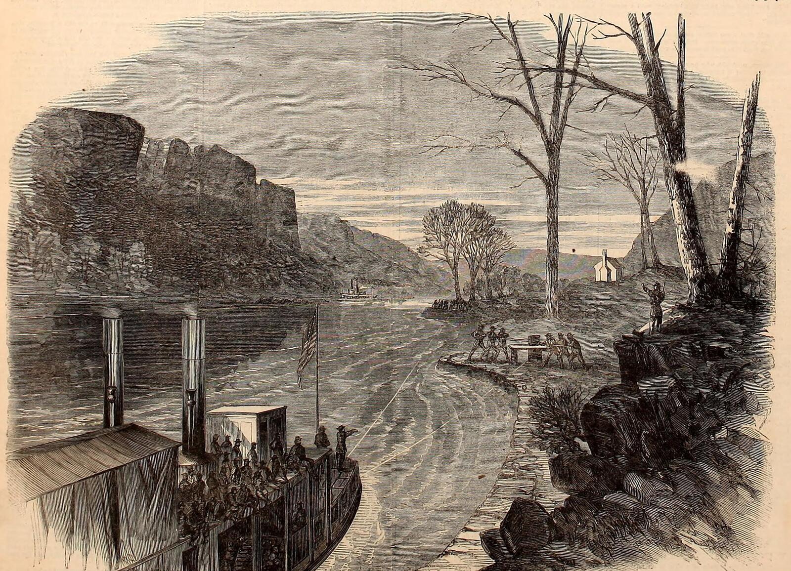
The Tennessee River once ran wild through this reach of the gorge. Before the first dams, a series of named rapids and eddies, “The Suck,” “The Boiling Pot,” “The Skillet,” and “The Frying Pan,” turned the passage through the gorge into one of the most dangerous stretches of river on the interior waterway system. Flatboats and rafts were lined through on ropes or broken up and rebuilt below. Early travelers' accounts describe cargoes lost and men drowned in the rapids. The Suck was the largest and most talked about of the group and lent its name to the creek that enters the river at its mouth.
The rapids were effectively erased by the 1913 completion of Hales Bar Dam downstream and, later, by the 1967 replacement with Nickajack Dam. The pool that now stands at roughly 633 feet above sea level covers the old boulder-strewn channel, and the water that passes the mouth of Suck Creek today moves at lake speed rather than in the white-water that gave the place its name. See The Suck and the gorge rapids for the long-form account.
Suck Creek Road and the first highway through the gorge
Until the 20th century there was no practical road along the Tennessee River on the north side of the gorge; travelers went by water, by ferry, or up and over Walden's Ridge. The route that became TN-27 was pushed through the gorge as a segment of the national Dixie Highway, the Miami-to-Michigan automobile route that organized local road projects across the South after 1915.
Construction of the Suck Creek segment was done in large part with convict labor from Brushy Mountain State Penitentiary, a pattern that was common in early 20th-century Tennessee road building and that sat within the state's broader convict-lease and convict-labor system. Work began in 1915, was interrupted by the First World War and the 1918 influenza pandemic, and was finished between 1920 and 1921; the road officially opened to through traffic in May 1921, giving the gorge its first motor route. The route was later straightened and widened, with significant curve-easing work in the 1980s, and today carries the TN-27 designation along with its local name, Suck Creek Road.
The August 1982 flood
On August 16, 1982, a slow-moving summer thunderstorm dumped a concentrated rainfall on the Suck Creek drainage and the face of Walden's Ridge. The creek rose rapidly from its normal low summer flow, tore out the Suck Creek Bridge on TN-27 near the county line, and closed the gorge road to through traffic. Secondary damage to roads, culverts, and private property extended up the drainage and onto the lower slopes of Walden's Ridge. Reconstruction of the bridge and road repairs took months, and the event is still remembered locally as the defining Suck Creek flash flood of the late 20th century.
Present day
The Marion County portion of Suck Creek is a narrow strip of rural residential property along TN-27, with small pull-offs for fishing access and a handful of commercial uses on the wider stretches of the valley floor. It lies within the commuting shed of both Chattanooga (about 15 miles downriver) and Jasper (about 20 miles upriver), and many residents work in the greater Chattanooga economy while living inside the gorge. Prentice Cooper State Forest on the plateau above the community supports hiking, hunting, and a designated scenic driving route that connects to the Cumberland Trail. The community has no separate government, no school, and no post office of its own; it is defined by the creek, the road, and the gorge walls.
Related
The Suck and the gorge rapids →
Tennessee River Gorge →
Mullins Cove →
Powells Crossroads →
Transportation and railroads →