Last updated: April 28, 2026
- Type: Abandoned coal-camp company town
- Founded: Early 1880s by David McNabb
- Mines closed: 1905
- Other operators: Williams Brothers (early 20th century)
- Location today: 457-acre site within Prentice Cooper State Forest, accessible from Mullins Cove Road on the north side of the Tennessee River Gorge
- National Register of Historic Places: Listed 2008 (McNabb Mines)
- Cultural Heritage Mining Trail: Listed site
Shake Rag was the company-town settlement that grew up around the McNabb Mines on the southern end of Walden's Ridge between the early 1880s and 1905, perched on a bluff overlooking the Tennessee River deep in the gorge. At its peak the camp held drift mines and tipples, an incline plane that ran coal down to a river loading point, beehive coke ovens, a company store, worker housing, a two-story hotel, and a church. When the mines permanently shut down in 1905, the camp emptied; the buildings were left in place. Today the site sits inside Prentice Cooper State Forest, on the National Register of Historic Places since 2008, with stone ruins and the trace of the incline plane still visible from Mullins Cove Road.
Setting
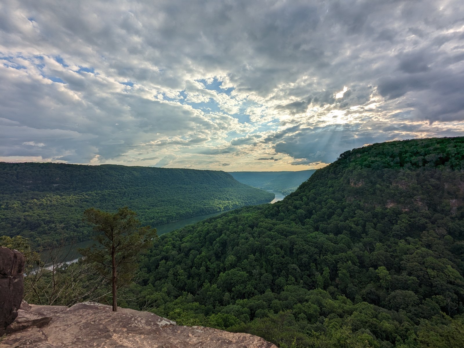
Shake Rag occupied a bluff on the north side of the Tennessee River Gorge, near the southern end of Walden's Ridge in southeastern Marion County. The river runs through a narrow canyon here, with the Cumberland Plateau rim 800 to 1,000 feet above the water on both sides. The gorge stretches roughly from the foot of the Sequatchie Valley downstream to Williams Island near Chattanooga; Shake Rag sat in the upper-middle of that stretch, on the Marion County side. Coal seams outcrop at several elevations along the bluff, and the McNabb Mines were driven into the seam roughly halfway up the cliff face. An incline plane carried coal from the mine mouths down to a tipple and river loading at the water's edge, where flatboats and later steamboats took the output downriver to Chattanooga.
Modern access is from the north through Prentice Cooper State Forest via Mullins Cove Road, which winds along the plateau-top above the gorge before descending to the cove. The site is on private timber land in some sections and inside the state forest in others; the most-visible stone ruins, including the company-store foundation, the hotel footprint, and the incline trace, are visible from roadside pullouts. The McNabb Mines page on the Cultural Heritage Mining Trail lists Shake Rag as one of the most intact 19th-century coal-camp ruins in the Tennessee Cumberland Plateau region.
The McNabb Mines (1880s–1905)
David McNabb, of the Hamilton-County McNabb pioneer family, came down the Tennessee River from upper East Tennessee in the early 1880s and established the coal operation that would carry his name. McNabb chose the bluff site for its workable seams and its river access: with the Nashville & Chattanooga Railroad following the Sequatchie Valley to the north and skirting the gorge to the south, river transport was the only practical bulk-shipping route for the gorge-rim coal seams in the early 1880s.
The McNabb operation was substantial for its remote setting. By the late 1880s and into the 1890s the mines included multiple drift entries, surface tipples, an incline plane that dropped coal down the cliff face to the river, a row of beehive coke ovens, a company store, worker housing, a two-story hotel for visiting buyers and engineers, and a church. The mines fed both the household coal market and small-foundry coke buyers in Chattanooga and downriver Alabama; output was modest by Whitwell or Tracy City standards but commercially viable for a single-operator family mine.
Like most Cumberland Plateau coal camps of the period, the operation ran on company script. Workers were paid in McNabb-issued tokens and paper rather than U.S. currency, which they spent at the company store and used to rent the company-owned cabins. The arrangement bound the camp together economically and gave the company effective control over both labor costs and worker mobility, and it produced the chronic indebtedness that defined the late-19th-century coal-camp economy across the plateau.
The Williams Brothers and the Shake Rag name
Local accounts assemble Shake Rag's operational history from at least two operator families. Alongside the McNabb family, the Williams Brothers held coal interests at the same site at one or another point in the late 19th century, and a March 2019 Chattanoogan column titled “Williams Brothers Had Coal Interests in Marion County; Community Was Later Known As Shakerag” treats the Williams Brothers as the early-period operator and the McNabb family as the longer-running successor. The precise sequence of operator changes is not fully documented in the surviving sources, but the camp consistently appears in late-19th-century accounts under the local name Shake Rag, even when the mining operation itself was being called the McNabb Mines in commercial directories.
The folk-name “Shake Rag” itself comes from how camp residents got into and out of the gorge. With no road suitable for wagons in the early period and the railroad on the far side of the river, residents who needed to travel would stand at the river's edge and wave a rag at passing boats to flag them down for a ride. The “Shake Raggers,” as boat pilots called them, became distinctive enough to give the camp its informal name. The McNabb Mines name was the formal one that appeared on commercial invoices, federal records, and later National Register paperwork; Shake Rag was what the camp was called locally, and it is the name that survived after the mines closed.
1905: shutdown and abandonment
The McNabb Mines shut down permanently in 1905, and the camp was abandoned. Coal output from gorge-rim operations was being outcompeted by the larger Sequatchie Valley mines feeding the South Pittsburg and Whitwell rail-served network, and the McNabb seam was nearing exhaustion at workable elevations. With the mines closed, the camp had no independent economy, and within a few years the population had moved away. Unlike nearby coal-rim sites that converted to timber or saw secondary use, Shake Rag was simply left in place. The remoteness that had given the camp its name made it impractical to repurpose the structures, and the site reverted to forest.
The site today
The Shake Rag / McNabb Mines site is now part of Prentice Cooper State Forest, the 26,000-acre Tennessee Department of Agriculture forestry reserve along the north side of the Tennessee River Gorge. The most-intact 457 acres of the camp footprint were added to the National Register of Historic Places in 2008 under the name McNabb Mines, recognized as a remarkably intact 19th-century mining community significant to the industrial, engineering, social, and commercial history of the Cumberland Plateau region.
Stone ruins and the trace of the incline plane are visible from Mullins Cove Road and from connecting trails in the state forest. The most-visible features are the company store foundation, the row of beehive coke-oven mouths along the cliff base, segments of the incline plane retaining wall climbing the cliff face, and scattered worker-cabin foundation lines in the wooded plateau-top above the river. The hotel and church footprints are harder to identify under the modern undergrowth. A 2010 preservation meeting of local cavers and historians, organized through the Tennessee Cave Survey and Chattanooga-area heritage groups, produced the first contemporary documentation effort; the site is now a regular stop on the Cultural Heritage Mining Trail of Southeast Tennessee, a self-guided driving and hiking tour that connects coal, copper, iron, and foundry sites across the eastern plateau.
Why the place still matters
Shake Rag's significance is not in the size of its operation, which was modest, but in its preservation. Most 19th-century Tennessee coal camps were either bulldozed for modern surface mining, repurposed for timber operations, swallowed by larger company towns, or left to rot under heavy undergrowth without ever being formally documented. The Shake Rag bluff was remote enough that nobody bothered to rebuild on it, and steep enough that the stone foundations and incline retaining walls survived without structural compromise. The result is a near-textbook example of what a Cumberland Plateau coal camp's physical layout actually looked like: the relationship between the seam, the drift entry, the tipple, the incline, the river loading, the company-store core, and the scatter of worker cabins along the plateau-top. For an industry that defined Marion County and the broader plateau economy from the 1850s into the 1930s, the survival of a single intact example carries disproportionate historical weight.
Related
Mullins Cove (the Tennessee River Gorge cove that holds Mullins Cove Road) →
Prentice Cooper State Forest →
Tennessee River Gorge →
Marion County coal & coke industry overview →
Battle Creek Mines (the contemporaneous lower-creek operation that became South Pittsburg) →
Other named places in Marion County →
Sources
- TAG Cavers / Underground Earth — McNabb Mines, Shake Rag (history, current ruins, NRHP designation)
- Chattanoogan — Williams Brothers Coal Interests in Marion County / Shakerag (March 2019)
- Chattanoogan — The Heat is On: Coal (Marion County coal-camp history)
- Chattanoogan — McNabb Mines Preservation Meeting (September 2010)
- Chattanoogan — Hamilton County Pioneer Family: McNabb
- SGnTN — McNabb Mines (photos and field notes)
- LandmarkHunter — McNabb Mines (NRHP record)
- National Archives Catalog — McNabb Mines
- Cultural Heritage Mining Trail of Southeast Tennessee (PDF guide; McNabb Mines listing)
- HometownLocator — McNabb Mines feature map